Situation Summary
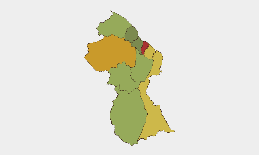
Guyana remains a moderate-risk environment (composite threat score 7) with persistent vulnerability to drug trafficking, localized gang activity, and petty-to-serious crime concentrated in coastal urban centers. The country's role as a transit hub for South American narcotics and its rapid oil-sector expansion continue to attract criminal networks and organized crime. Overall security conditions remain stable, but sub-national variance is significant, with Demerara-Mahaica (risk 78) and Cuyuni-Mazaruni (risk 72) substantially exceeding national average threat levels.
Key Developments
- Providence, East Bank Demerara – 18 June 2026 (12:00 hrs)
Guyana Police Force anti-narcotics operation recovered suspected cannabis and cocaine quantities and arrested one individual; investigation ongoing per *Guyana Chronicle* report. Indicates continued drug-trafficking presence in densely populated residential areas near Georgetown.
- Limited corroborated open-source activity in last 48 hours
Routine crime reporting and political commentary dominate recent feeds; no major incidents, infrastructure disruptions, or security alerts independently verified across multiple sources during the reporting window.
Highest-Risk Areas
Demerara-Mahaica (78) and Cuyuni-Mazaruni (72) drive national risk scores, reflecting Georgetown and its greater metro area's concentration of narcotics trafficking, gang activity, and property crime, combined with Cuyuni-Mazaruni's remote mining regions and porous interior border with Venezuela. Mahaica-Berbice (65) and East Berbice-Corentyne (62) follow, indicating consistent criminogenic pressure along the Atlantic coast and eastern hinterland. Inland and western regions (Potaro-Siparuni, Barima-Waini, Upper Takutu–Upper Essequibo) show lower composite scores but remain subject to smuggling and cross-border dynamics. Corporate and development assets concentrated in coastal zones face proportionally elevated exposure to robbery, theft, extortion, and supply-chain disruption.
How GeoBit Would Assist
AOI Monitoring & Early Warning with persistent watch over high-risk zones (Providence, East Bank Demerara, central Georgetown) and remote mining/border regions would provide real-time alert feeds on police operations, gang activity, and trafficking indicators. OSINT Fusion & Corroboration across Guyana Police Force statements, local press (*Guyana Chronicle*, *Stabroek News*), X/Twitter, Telegram, and YouTube would isolate genuine, time-stamped incidents from rumor and dated reports, enabling duty-of-care teams to verify threats and adjust protocols. Routing & Network Analysis would model safer transit corridors for personnel and supply shipments, accounting for crime hotspots and alternative routes away from highest-risk districts. GIS & Spatial Analysis layered with sub-national risk scores allows security teams to map asset locations, employee residences, and critical facilities against regional threat gradients and adjust resource deployment accordingly.
7-Day Outlook
No major security escalation is anticipated in the immediate term. Drug-trafficking and localized property crime will likely persist at current baseline levels, with sporadic police operations continuing along the coast and interior. Teams should maintain standard protocols for high-risk urban areas, monitor police/government communications for operational announcements, and ensure contingency plans remain current for rapid personnel relocation if regional instability or organized-crime activity intensifies.
Highest-Risk Areas — Ranked
| # | State / Region | Risk |
|---|---|---|
| 1 | Demerara-Mahaica | 78 |
| 2 | Cuyuni-Mazaruni | 72 |
| 3 | Mahaica-Berbice | 65 |
| 4 | East Berbice-Corentyne | 62 |
| 5 | Upper Demerara-Berbice | 58 |
| 6 | Potaro-Siparuni | 48 |
| 7 | Barima-Waini | 45 |
| 8 | Upper Takutu-Upper Essequibo | 42 |
| 9 | Pomeroon-Supenaam | 38 |
| 10 | Essequibo Islands | 35 |