Situation Summary
Niger's security environment has sharply escalated following a military-decreed nationwide mobilization and U.S. airstrikes on jihadist targets in neighboring Nigeria. The junta has consolidated emergency powers, activated a tri-border counterterrorism force with Mali and Burkina Faso, and repositioned security doctrine toward Russia and regional partners while distancing from Western alignment. Risk of cross-border militant spillover, coupled with internal requisition authority and reserve callup, signals a transition to sustained conflict footing with potential for civilian disruption and asset seizure.
Key Developments
- Nationwide mobilization decree (2 June). Niger's military signed sweeping authorization for state requisition of citizens, property, and services; permits rapid war-footing deployment to address internal and external threats and territorial integrity challenges.
- Nigeria–Niger border alert (1–2 June). Following U.S. airstrikes on ISIS-linked targets in Nigeria's northwest, Nigerien authorities elevated security-force readiness along the northern frontier to forestall militant displacement into Niger.
- Tri-border force activation (recent). Niger, Mali, and Burkina Faso formally launched joint counterterrorism operations across shared borders, signaling coordinated Sahel strategy independent of Western partners and concentration of jihadist pressure points.
- Geopolitical pivot in Niamey (ongoing). Military leadership publicly emphasized Russia alignment and reduced Western partnership, framing mobilization and border reinforcement as part of broader regional security doctrine realignment.
- Southern and western corridor reinforcement (1–2 June). Security planners expanded monitoring and rapid-reaction capabilities along key routes linking to Burkina Faso and Nigeria conflict zones, anticipating jihadist retaliation or cell displacement.
- Military logistics expansion (concurrent with decree). Garrison and hub infrastructure in Niamey and Tillabéri region authorized for expanded requisition, reservist callup, and civilian-service redirection supporting operations in Liptako-Gourma and broader jihadist-affected regions.
- State messaging on sovereignty and readiness (1–2 June). Official channels stressed deterrence of external aggression and internal conflict readiness, amplifying regional anxiety over U.S. operations and Sahel insurgency persistence.
Highest-Risk Areas
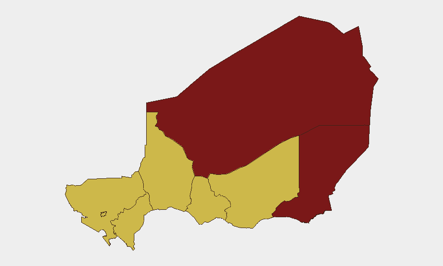
Agadez and Diffa regions drive Niger's composite threat profile at 94.9 and 94.0 respectively, reflecting active jihadist presence, cross-border militant flow, and limited state capacity. Tahoua and Niamey (67.5 and 67.0) present secondary but significant risk through proximity to conflict zones and concentration of political/military decision-making vulnerable to instability spillover. The southern tier—Zinder, Tillabéri, Dosso, and Maradi—each score 64.9, indicating sustained but lower-intensity jihadist and criminal activity; southern regions remain potential infiltration corridors from Nigeria and Burkina Faso, particularly under current mobilization and heightened cross-border tension.
How GeoBit Would Assist
Security teams should deploy AOI Monitoring & Early Warning on Agadez, Diffa, and border corridors to track militant movement and state-force repositioning in real time. Conflict & Military analysis—including force structure, weapons capability, and battle-mapping—will clarify junta operational intent and reserve callup scope. OSINT fusion and Telegram/X intelligence will surface state-media narratives, requisition orders, and cross-border coordination signals; routing and network analysis will identify alternative supply and escape routes for personnel and asset protection planning.
7-Day Outlook
Expect consolidation of mobilization authority, intensified border patrols, and possible asset requisition in logistics hubs and garrison towns. Cross-border jihadist activity and retaliatory cells displaced by U.S.–Nigeria strikes pose elevated risk to southern and eastern regions through mid-June. Geopolitical realignment toward Russia and regional actors will likely reduce Western intelligence sharing and increase unpredictability in state responses to foreign nationals and corporate operations.
Highest-Risk Areas — Ranked
| # | State / Region | Risk |
|---|---|---|
| 1 | Agadez Region | 94.9 |
| 2 | Diffa Region | 94 |
| 3 | Tahoua Region | 67.5 |
| 4 | Niamey | 67 |
| 5 | Zinder Region | 64.9 |
| 6 | Tillabéri Region | 64.9 |
| 7 | Dosso Region | 64.9 |
| 8 | Maradi Region | 64.9 |