Situation Summary
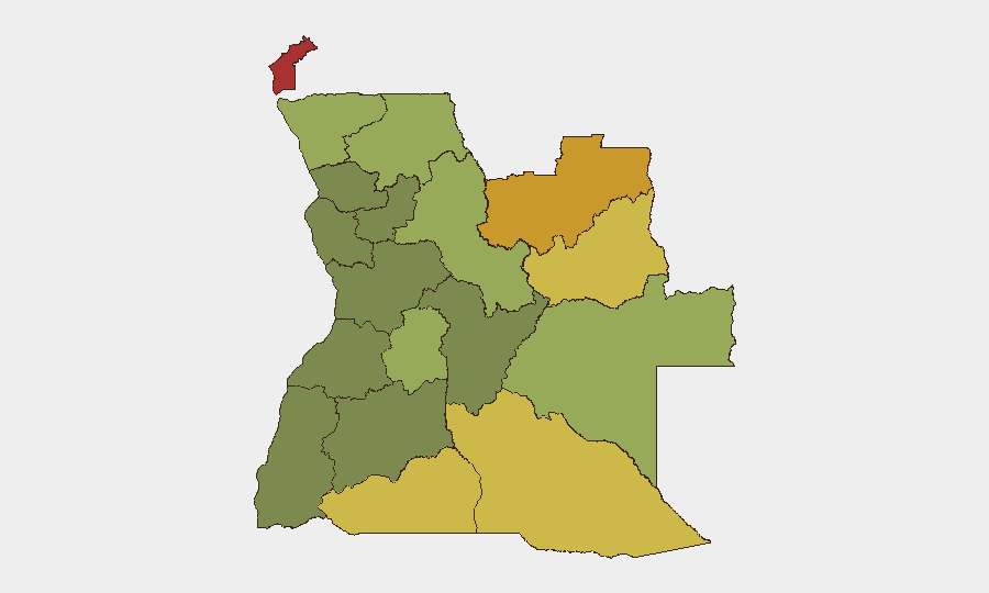
Angola remains a moderate-risk jurisdiction (global rank #46, composite score 40) with no tracked security events in the past 24–48 hours. The country's risk profile is heavily concentrated in its eastern and northeastern provinces, driven by illicit-resource trafficking, organized crime, and cross-border criminality. Recent cyber and violent-crime incidents (late August) indicate persistent vulnerabilities in critical infrastructure and law-enforcement capacity, though no active civil unrest or major security events are confirmed for 30–31 August 2026.
Key Developments
- Cyber‑attack on Unitel (primary mobile operator) – nationwide, Angola – 26 August 02:20 local time: A major cyberattack disrupted voice, SMS, home internet, digital payments, and app-based services across Angola; restoration of 2G/3G networks was ongoing as of 29 August, with continued constraints on banking and mobile-money transfers affecting millions of users. *Risk impact:* operational disruption, payment delays, reduced emergency-communication reliability.
- Extradition and detention of international bank-cybercrime suspect – Luanda – 25 August: Angola's Criminal Investigation Service (SIC) received via extradition from Portugal an Angolan suspect linked to an international cyber-attack network targeting Angolan banks; 10 suspects are in pre-trial detention, with ongoing operations to locate additional network members. *Risk impact:* financial-sector cybercrime and organized cyber-criminal activity.
- Alleged violent homicides and cannibalism – Bié Province (Luando, Camacupa) – arrests reported 27 August: SIC arrested two suspects (aged 31 and 38) in connection with the killing and consumption of six victims; cases span 2010, 2012, and 2026, indicating serious violent crime and possible ritualistic elements. *Risk impact:* severe violent crime, localized community disturbance.
- Police–opposition clashes and injuries – Uíge Province – late August (prior to 27 August): UNITA (main opposition party) reported 31 injuries, 10 serious, sustained when police dispersed militants near party facilities; police stated non-lethal dispersal of an unlawful assembly. *Risk impact:* civil unrest, police–opposition tension, injury-risk exposure.
- Death of Brazilian national linked to drug trafficking – Luanda – late August: Investigators detained three individuals in connection with the death of a 49-year-old Brazilian found with evidence of violence in a hotel; the victim had allegedly smuggled 94 capsules of cocaine. *Risk impact:* organized narcotics trafficking, hospitality-sector violence.
- Cross-border human trafficking – Tomboco, Zaire Province – 25 August: Police arrested two suspects for abducting two women (21, 22) from Luanda to smuggle across the Luvo border into the Democratic Republic of Congo. *Risk impact:* transnational human trafficking, border-control weaknesses.
Highest-Risk Areas
Cabinda Province (risk 78) and the Lunda Norte/Sul cluster (72, 68) dominate Angola's sub-national threat landscape, driven by illegal diamond and mineral extraction, armed-group activity, and cross-border trafficking. Cuando Cubango and Cunene provinces (64, 62) extend this risk corridor along the Namibian and Zambian borders. These eastern and northeastern zones lack state capacity, attract organized criminal networks, and experience limited law-enforcement presence—creating environments conducive to trafficking, smuggling, and armed exploitation of resources.
How GeoBit Would Assist
Organizations with staff or assets in Angola should employ AOI Monitoring & Early Warning to track the highest-risk provinces and receive alerts on emerging crime, trafficking, and civil unrest. OSINT fusion and multi-language search capabilities enable real-time monitoring of Angolan media, opposition communications, and law-enforcement announcements to detect early signs of political tension or security deterioration. Network & Actor Analysis would map criminal and trafficking networks active in the eastern provinces, informing route-planning and personnel-movement decisions.
7-Day Outlook
No major security escalation is anticipated in the next seven days, though the Unitel cyber-attack recovery may extend operational disruptions into early September. Political tensions between government and opposition remain elevated but localized; monitoring Uíge and other northern provinces for additional police–opposition clashes is warranted. Transnational trafficking and organized crime in eastern provinces will continue as baseline chronic threats.
Highest-Risk Areas — Ranked
| # | State / Region | Risk |
|---|---|---|
| 1 | Cabinda Province | 78 |
| 2 | Lunda Norte Province | 72 |
| 3 | Lunda Sul Province | 68 |
| 4 | Cuando Cubango Province | 64 |
| 5 | Cunene Province | 62 |
| 6 | Moxico Province | 58 |
| 7 | Zaire Province | 54 |
| 8 | Huambo Province | 50 |
| 9 | Uíge Province | 48 |
| 10 | Malanje Province | 42 |
| 11 | Bié Province | 35 |
| 12 | Huíla Province | 32 |
Sources
Previous Daily Briefs
A new Angola brief is written every day — each with its own risk map and downloadable CSV. Here's the last week; use the calendar to go further back.
- August 29, 2026
- August 27, 2026
- August 25, 2026
- August 23, 2026
- August 21, 2026
- August 19, 2026
- August 17, 2026
📅 Browse every day by calendar →
Highlighted days have a brief. Tap a day for that day's map & analysis, or “csv” for that day's dataset ($5).
Atlas — our AI intelligence desk — emails them this snapshot personally. Nothing else, no list.