Situation Summary
Togo remains a relatively low-threat operating environment globally (composite score 9), but faces sharply elevated risk in its northern regions due to persistent jihadist spillover from Burkina Faso and Mali. The most recent tracked event—a 2026-06-18 arrest or detention incident involving Togolese nationals and the African Union—signals potential instability in governance or cross-border actor management. The security picture is bifurcated: the Maritime Region and southern urban centers (Lomé) remain stable; the Savanes and Kara regions in the north present acute and sustained threats.
Key Developments
No credible, time-stamped security incidents meeting cross-source confirmation thresholds were identified in the last 24–48 hours (2026-06-17 to early 2026-06-19 UTC) via open-source news or social media feeds. The most recent tracked signal is the 2026-06-18 arrest/detention event involving Togolese and African Union actors, but open reporting does not yet clarify location, nature, or operational impact. Given Togo's limited international media footprint, specialist security platforms and regional West African news agencies may carry corroborating details not yet indexed globally. Duty-of-care teams should monitor official embassy alerts, UN agency advisories, and local Togolese government statements for confirmation and context.
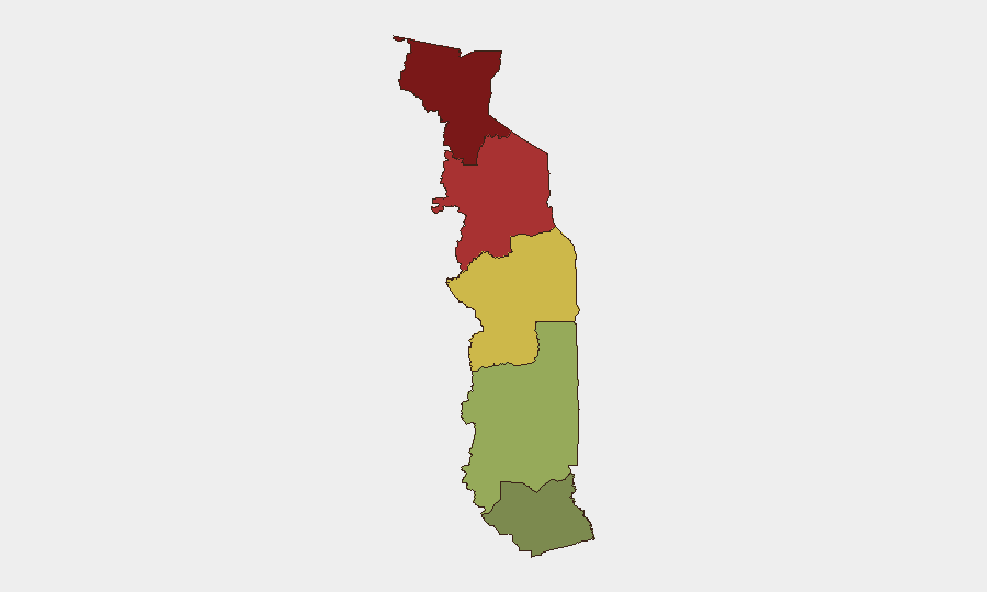
Highest-Risk Areas
The Savanes Region (northern border with Burkina Faso; risk score 92) and Kara Region (central-north; risk score 78) drive the country's composite threat profile. Both regions experience recurring jihadist activity, including armed-group incursions, IED incidents, and banditry targeting civilians and commercial corridors. The Centrale Region (risk 65) faces secondary risk from spillover and cross-border transit. Southern regions—Plateaux (45) and Maritime (28)—are substantially lower-risk but remain subject to petty crime and protest-related disruptions common in urban centers. Any corporate footprint north of Lomé or in border-adjacent districts should assume elevated threat and implement zone-specific contingency planning.
How GeoBit Would Assist
Teams with personnel or logistics in Togo should employ AOI (Area-of-Interest) Monitoring & Early Warning on the Savanes and Kara regions to detect incidents—clashes, roadblocks, mass movement—before they affect operations. Multi-language OSINT (French, Ewé, regional outlets) and Network & Actor Analysis of jihadist and militia groups active in northern Togo and cross-border sanctuaries will provide tactical context and early signals of escalation. Alternative Route & Network Analysis can help identify safe passage corridors around high-risk zones if travel or supply-chain continuity is required.
7-Day Outlook
No imminent shift in the northern threat posture is signaled by current open-source data. The 2026-06-18 arrest incident may reflect internal political tensions or border-enforcement operations; outcomes will likely clarify within 3–5 days via government or international organization statements. Togo's dry season (June–August) historically correlates with increased jihadist mobility in the Sahel, warranting sustained vigilance on Savanes and Kara corridors and on cross-border intelligence sharing between Togolese, Burkinabè, and Malian security forces.
Highest-Risk Areas — Ranked
| # | State / Region | Risk |
|---|---|---|
| 1 | Savanes Region | 92 |
| 2 | Kara Region | 78 |
| 3 | Centrale Region | 65 |
| 4 | Plateaux Region | 45 |
| 5 | Maritime Region | 28 |
Sources
Previous Daily Briefs
A new Togo brief is written every day — each with its own risk map and downloadable CSV. Here's the last week; use the calendar to go further back.
📅 Browse every day by calendar →
Highlighted days have a brief. Tap a day for that day's map & analysis, or “csv” for that day's dataset ($5).