Situation Summary
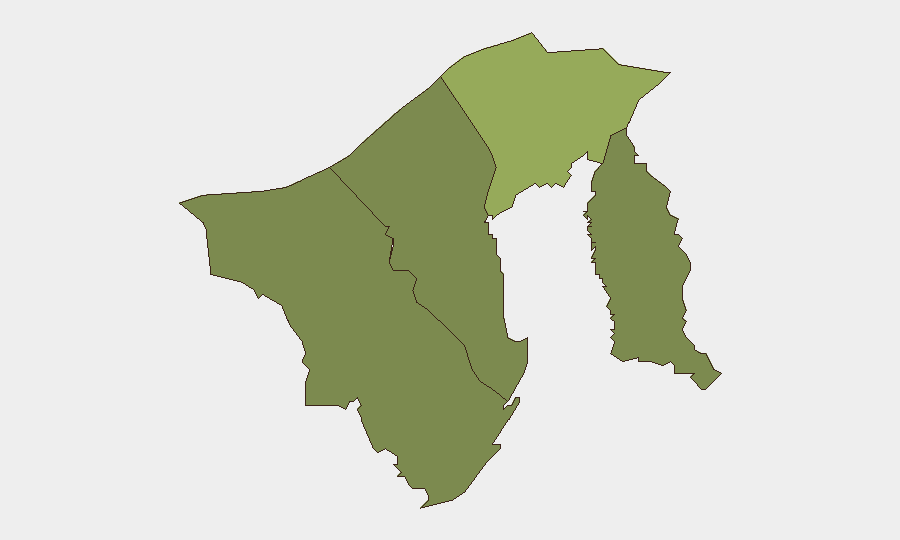
Brunei remains a low-threat environment with a composite threat score of 5 (global rank #165) and no confirmed security incidents in the current reporting window. Air quality degradation from transboundary smoke and a circulated social-media rumor were the only substantive developments in the past 48 hours; neither poses an immediate risk to corporate operations or personnel. The security baseline remains stable, with routine governance and normal commercial activity continuing across all four districts.
Key Developments
- Brunei-wide air quality degradation — Aug. 30, 2026 — Haze from Indonesian forest and land fires across Borneo drifted into Brunei airspace; official pollution readings in all districts remained in the good-to-moderate range, but conditions warrant monitoring for vulnerable populations and outdoor operations.
- Transboundary haze risk escalation — Aug. 30, 2026 — Regional wildfire activity in Indonesia is projected to increase smoke drifting toward Brunei; no immediate air-quality emergency declared, but corporate travel and outdoor event planning should account for potential visibility and respiratory impacts.
- Social-media rumor (debunked) — Aug. 29–31, 2026 — Bandar Seri Begawan and nationwide social platforms circulated an unverified claim linking a local photo to fugitive Sukumara Kurup; Brunei police clarified the image was of Damodara Menon and the story was speculation. No security incident; illustrates local social-media susceptibility to misinformation.
- No confirmed civil unrest, crime spikes, or infrastructure disruptions — Current 24–48 hour period shows no verified incidents of violence, protests, theft, or service outages in major commercial or residential zones.
Highest-Risk Areas
Brunei-Muara District (risk score 45) remains the primary concentration point, driven by its status as the capital region, largest population center, and location of Bandar Seri Begawan's commercial, diplomatic, and port infrastructure. Tutong District (score 20) and Belait District (score 15) carry moderate residual risk, likely reflecting population density and economic activity; Temburong District (score 10) presents the lowest profile. The scoring reflects structural vulnerability and asset concentration rather than active incidents; no current event has materially elevated any district's standing.
How GeoBit Would Assist
Corporate security teams with Brunei operations should employ AOI Monitoring & Early Warning on Bandar Seri Begawan and port facilities to detect supply-chain disruptions or service outages in real time. Environmental & Health monitoring and multi-language social-media OSINT (X/Twitter, Telegram, local platforms) enable early detection of air-quality escalation, public-health alerts, or emergent civil unrest before they impact duty-of-care compliance or personnel safety. Alternative route and network analysis can support contingency planning if transboundary haze or infrastructure disruptions necessitate supply-chain or personnel rerouting.
7-Day Outlook
Transboundary haze is likely to remain the primary near-term operational factor; corporate teams should monitor official Brunei air-quality updates and prepare dust-mitigation protocols for sensitive outdoor or supply-chain activities. No significant escalation in security incidents, civil unrest, or crime is anticipated in the coming week. The environment remains permissive for normal business operations; situational awareness on air quality and regional wildfire trends is the primary duty-of-care requirement.
Highest-Risk Areas — Ranked
| # | State / Region | Risk |
|---|---|---|
| 1 | Brunei-Muara District | 45 |
| 2 | Tutong District | 20 |
| 3 | Belait District | 15 |
| 4 | Temburong District | 10 |
Sources
Previous Daily Briefs
A new Brunei brief is written every day — each with its own risk map and downloadable CSV. Here's the last week; use the calendar to go further back.
- August 29, 2026
- August 26, 2026
- August 24, 2026
- August 22, 2026
- August 20, 2026
- August 18, 2026
- August 16, 2026
📅 Browse every day by calendar →
Highlighted days have a brief. Tap a day for that day's map & analysis, or “csv” for that day's dataset ($5).
Atlas — our AI intelligence desk — emails them this snapshot personally. Nothing else, no list.