Situation Summary
Afghanistan remains at elevated baseline threat (global rank #28, composite score 70) with persistent cross-border tensions, Taliban enforcement actions, and fragmented security incidents across multiple provinces. No confirmed, incident-level security events—attacks, unrest, or casualty events—have been verified in open-source reporting for the last 24–48 hours; the operational environment is characterized by structural instability rather than active acute incidents at present. Risk concentration is highest in eastern and central provinces, driven by Pakistan–Afghanistan border friction, Taliban administrative enforcement, and ongoing criminal activity. Corporate and NGO personnel should maintain standard elevated vigilance posture pending any shift in reporting or intelligence indicators.
Key Developments
No incident-level security events meeting recency and verification criteria have been confirmed in Afghanistan during July 15–17, 2026. Open-source media and social-media monitoring explicitly note the absence of localized attack, displacement, or casualty reporting in the last 24–48 hours, despite an underlying elevated threat baseline. Major urban centers including Kabul have reported no verified incidents in that window.
Background context (for situational awareness, not current events):
- Pakistani airstrikes and Taliban clashes along eastern border zones (late June–early July): dozens of casualties reported in Nangarhar and adjoining areas.
- Taliban women's dress-code enforcement actions and protest dispersal in Herat (early June): arrests and gunfire incidents documented.
- Localized crime incidents in Herat and Paktia (earlier July): taxi driver killing arrests; weapons seizures. Precise dating unavailable for last 48 hours.
- Diplomatic developments (recent, not security incidents): UN special representative appointment; Pakistan–Taliban normalization talks; Taliban drone-capability statements; migrant deportation operations.
Highest-Risk Areas
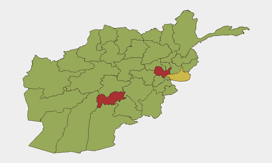
Kabul Province (78.7) and Uruzgan Province (76.9) dominate the risk ranking, with Kabul driven by urban density, government presence, and terrorism-attack history, and Uruzgan by Taliban territorial control and armed-group activity. Nangarhar Province (67.9) ranks third, reflecting active cross-border violence with Pakistan and militant presence in the eastern corridor. Eastern provinces (Kunar, Paktika, Nangarhar) and southern provinces (Helmand, Kandahar, Uruzgan) collectively account for the highest-risk cluster, with cross-border smuggling, narcotics trafficking, and Pakistan–Taliban friction zones sustaining elevated composite threat scores.
How GeoBit Would Assist
Security teams operating in Afghanistan should deploy AOI Monitoring & Early Warning on Kabul, Uruzgan, and Nangarhar to track emerging incident signals and checkpoint/displacement activity in real time. Intel Sweep and OSINT Fusion (X/Twitter, Telegram, local-language sources) provide rapid event verification and actor-sentiment analysis when incidents do occur, reducing reliance on delayed or unconfirmed social media rumors. Alternative Route & Network Analysis and GIS & Spatial Analysis enable rapid rerouting of personnel and asset movement away from active risk zones, particularly around border regions and Taliban-controlled checkpoints. Entity & Network Analysis supports identification of local security actors, Taliban administrative officials, and criminal networks relevant to duty-of-care assessments.
7-Day Outlook
No imminent shift in the current elevated baseline is forecast; cross-border tensions remain a structural driver and will likely sustain periodic violence in eastern provinces without major escalation. Taliban administrative enforcement and criminal activity will continue in fragmented, localized patterns. Monitoring should remain heightened for any spike in verified incident reporting or cross-border military activity that would signal tactical changes.
Highest-Risk Areas — Ranked
| # | State / Region | Risk |
|---|---|---|
| 1 | Kabul Province | 78.7 |
| 2 | Uruzgan Province | 76.9 |
| 3 | Nangarhar Province | 67.9 |
| 4 | Daykundi Province | 57.7 |
| 5 | Helmand Province | 55.9 |
| 6 | Kunar Province | 55.9 |
| 7 | Paktika Province | 52.9 |
| 8 | Zabul Province | 48.7 |
| 9 | Kandahar Province | 48.7 |
| 10 | Ghazni Province | 48.7 |
| 11 | Farah Province | 48.7 |
| 12 | Nimruz Province | 48.7 |
Previous Daily Briefs
A new Afghanistan brief is written every day — each with its own risk map and downloadable CSV. Here's the last week; use the calendar to go further back.
📅 Browse every day by calendar →
Highlighted days have a brief. Tap a day for that day's map & analysis, or “csv” for that day's dataset ($5).
Atlas — our AI intelligence desk — emails them this snapshot personally. Nothing else, no list.