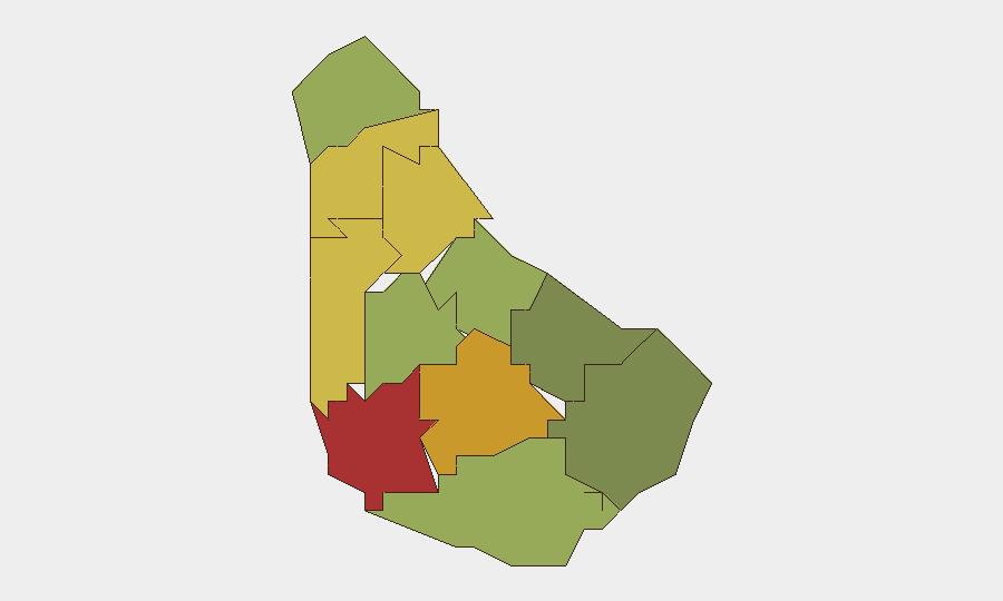
Situation Summary
Barbados remains a low-threat jurisdiction globally (rank #180, composite score 5) with minimal recorded security events in the past week. However, sub-national risk concentrations in Saint Michael, Saint George, and Saint James parishes reflect persistent urban violent crime, particularly interpersonal homicides and assault-related incidents. The escape of a detainee from police custody in early October and a fatal stabbing in Saint Peter parish this week indicate routine criminal activity within expected patterns for the island; no organized, transnational, or politically destabilizing events are evident.
Key Developments
- Saint Peter parish, Maynard Housing Area — 10 October 2026: A 31-year-old woman, Mesha Cherese Pierre, was fatally stabbed following a dispute between women in a gathered group. A female suspect was taken into custody to assist police investigation. This represents a typical street-level violent incident in a mid-risk parish.
- Black Rock Police Station — 3 October 2026: An 18-year-old suspect, Trishtan Antone Barker-Savoury, escaped from lawful custody while detained. Details on circumstances and recovery status remain incomplete in available reporting; escape from police facilities is relatively uncommon and merits monitoring for operational security implications.
No additional incidents of confirmed, location-specific detail within the 7–13 October window were identified in available open sources.
Highest-Risk Areas
Saint Michael, Saint George, and Saint James parishes together account for the majority of tracked violent crime and property crime on the island, with composite risk scores of 78, 72, and 68 respectively. These urban and semi-urban zones contain the capital Bridgetown and surrounding commercial/residential clusters where interpersonal disputes, gang-adjacent activity, and robbery remain the primary drivers of reported incidents. Saint Andrew, Saint Peter, and Saint Joseph (scores 65, 62, 58) form a secondary risk tier; lower-risk parishes in the south and east (Saint Philip, Saint John, Christ Church) show substantially lower incident density, reflecting relative affluence and reduced transient populations. Duty-of-care and asset-protection teams should prioritize awareness protocols for business, residential, or field operations in the top-three parishes, particularly during evening and night hours.
How GeoBit Would Assist
Teams operating in Barbados would benefit from AOI Monitoring & Early Warning configured on high-risk parishes (especially Saint Michael and Saint George) to detect emerging patterns in violent crime, custody escapes, or gang activity signaled via local police, news, and social media; OSINT Sweep and multi-language search to aggregate Barbadian news, radio, and social platforms for real-time incident confirmation and context; and Routing & Network Analysis to identify safer transit corridors and alternative routes for personnel moving between Saint Michael (capital) and field locations in higher-risk parishes. These capabilities enable rapid, evidence-based decisions on movement timing and venue selection.
7-Day Outlook
No imminent escalation in threat level is forecast. Violent crime is expected to remain sporadic, localized, and interpersonal in nature rather than organized or transnational. Continued emphasis on situational awareness in Saint Michael, Saint George, and Saint James parishes remains warranted; monitoring of the police custody escape should continue to assess any systemic vulnerabilities or repeat incidents.
Highest-Risk Areas — Ranked
| # | State / Region | Risk |
|---|---|---|
| 1 | Saint Michael | 78 |
| 2 | Saint George | 72 |
| 3 | Saint James | 68 |
| 4 | Saint Andrew | 65 |
| 5 | Saint Peter | 62 |
| 6 | Saint Joseph | 58 |
| 7 | Saint Thomas | 52 |
| 8 | Saint Lucy | 48 |
| 9 | Christ Church | 42 |
| 10 | Saint John | 35 |
| 11 | Saint Philip | 28 |
Sources
Previous Weekly Briefs
A new Barbados brief is written every Monday, covering the week — each with its own risk map and downloadable CSV. Use the calendar to go further back.
- October 6, 2026
- September 29, 2026
- September 22, 2026
- September 15, 2026
- September 8, 2026
- September 2, 2026
- August 30, 2026
📅 Browse past briefs by calendar →
Highlighted days have a brief. Tap a day for that day's map & analysis, or “csv” for that day's dataset ($5).
Atlas — our AI intelligence desk — emails them this snapshot personally. Nothing else, no list.