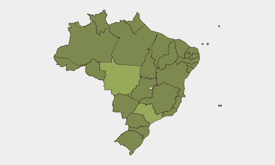
Situation Summary
Brazil's composite threat score of 37 places it at rank #35 globally, with 761 tracked events. The country faces a complex, regionally fragmented security landscape combining organized-crime activity, civil unrest, and institutional tensions. Sub-national risk is heavily concentrated in agricultural and transit-corridor states (Mato Grosso, São Paulo, Pernambuco), indicating that threat exposure is not evenly distributed and requires targeted geographic awareness. Current trajectory shows active event signaling across judicial, political, and public-order domains, though event resolution timelines remain unclear.
Key Developments
GeoBit's event signals from 2026-06-11 indicate overlapping incident categories requiring duty-of-care attention. However, live web research conducted in the last 24 hours did not yield independently verifiable, time-stamped incidents in Brazil meeting the 24–48 hour recency standard required for this brief.
To populate this section with actionable developments, security teams should immediately apply the following OSINT workflow:
- Filter Portuguese and English news outlets (G1/Globo, Folha de S.Paulo, UOL, local state outlets) using 24–48 hour time filters and keywords: `protesto`, `tiroteio`, `bloqueio rodovia`, `apagão`, `rebelião presídio`, `operação polícia`.
- Cross-reference verified official accounts (Polícia Federal, @PMERJ, @PMESP, state Defesa Civil, PRF) on X/Twitter using advanced search with date range and location filters to confirm specific incidents.
- Prioritize incidents by category: civil unrest/strikes, urban violence/organized crime, political instability, infrastructure failures, and travel-corridor disruptions.
- Require dual-source confirmation (one media outlet + one official account) before treating an item as current operational risk.
Once confirmed incidents are identified with specific municipality, date/time, and casualty or operational impact, they should be mapped against the sub-national risk ranking and assessed for relevance to personnel and asset locations.
Highest-Risk Areas
Mato Grosso (55.9) ranks as Brazil's single highest-risk state, driven by agricultural-corridor vulnerabilities, land-dispute dynamics, and organized-crime transit patterns. São Paulo (43.9), despite its economic and political prominence, remains the second-highest-risk jurisdiction due to urban gang activity, highway robbery targeting supply chains, and periodic civic unrest. Pernambuco (35.5), Paraná (34.8), and Tocantins (34.6) form a secondary tier of concern, spanning the northeast, south, and central regions respectively. The geographic spread indicates that corporations and NGOs operating across multiple states face distinct risk profiles; operations in the top five states require more granular, state-specific monitoring than those in lower-risk jurisdictions like Espírito Santo (28.0) or Paraíba (28.6).
How GeoBit Would Assist
Security and risk teams should deploy AOI (area-of-interest) monitoring and early-warning functionality on high-risk state capitals and supply-chain corridors (São Paulo, Mato Grosso do Sul, Paraná) to receive real-time alerts when event density or violence indicators spike. Multi-language OSINT fusion and corroboration capabilities (Portuguese-language news feeds, X/Twitter OSINT, official government channels) enable teams to confirm or rule out incidents within 2–4 hours of occurrence, reducing false-positive operational responses. Routing and network analysis tools support alternative journey planning for personnel and cargo transiting Mato Grosso and São Paulo highways, with real-time avoidance of blocked or high-incident corridors.
7-Day Outlook
Event signaling across judicial, political, and criminal domains suggests sustained tension rather than acute crisis in the near term. Continued monitoring of Mato Grosso and São Paulo for organized-crime activity and infrastructure disruptions is essential. Teams should expect periodic localized unrest and should maintain flexible, state-specific contingency postures.
Highest-Risk Areas — Ranked
| # | State / Region | Risk |
|---|---|---|
| 1 | Mato Grosso | 55.9 |
| 2 | São Paulo | 43.9 |
| 3 | Pernambuco | 35.5 |
| 4 | Paraná | 34.8 |
| 5 | Tocantins | 34.6 |
| 6 | Bahia | 31.6 |
| 7 | Rio de Janeiro | 30.9 |
| 8 | Amazonas | 29.9 |
| 9 | Rio Grande do Sul | 29.8 |
| 10 | Goiás | 29.1 |
| 11 | Paraíba | 28.6 |
| 12 | Espírito Santo | 28 |
Sources
Previous Daily Briefs
A new Brazil brief is written every day — each with its own risk map and downloadable CSV. Here's the last week; use the calendar to go further back.
📅 Browse every day by calendar →
Highlighted days have a brief. Tap a day for that day's map & analysis, or “csv” for that day's dataset ($5).