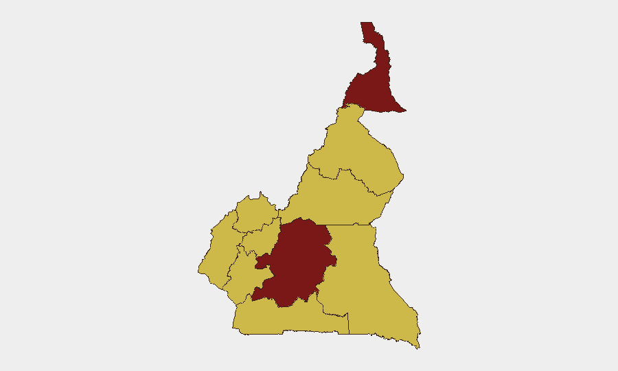
Situation Summary
Cameroon's security environment has deteriorated markedly over the past 48 hours, with confirmed Boko Haram attacks in the Far North, conventional military engagements on both the Nigeria and Chad borders, and nationwide military mobilization by the Cameroonian Armed Forces. The composite national threat score remains at 95 (rank #24 globally), but sub-national volatility—particularly in the Far North (96.2)—reflects acute localized risk. Multiple concurrent security pressures across internal insurgency, cross-border military tension, and law-enforcement activity indicate a fragmented but widespread security posture deterioration rather than a single focal crisis.
Key Developments
- Tourou village, Mayo-Tsanaga, Far North | Night of 13 July 2026
Boko Haram attack on a Cameroonian army outpost killed one civilian woman and wounded four soldiers; attack confirmed by security and local sources.
- Dabanga village, Waza district, Logone-et-Chari, Far North | Night of 16–17 July 2026
Suspected Boko Haram fighters conducted a nighttime raid along National Highway 1, killing seven villagers and injuring several others; incident confirmed by local traditional authority.
- Cameroon–Nigeria border sectors | Around 15–16 July 2026
Confirmed conventional military engagements between Cameroonian and Nigerian forces; live-fire interactions reported, exact locations and casualty figures pending corroboration in open sources.
- Cameroon–Chad border sectors | Around 15–16 July 2026
Conventional military engagements between Cameroonian and Chadian forces on frontier; incidents confirmed as recent military-to-military activity rather than exercises; specific locations and scale not yet publicly detailed.
- Nationwide | 15–16 July 2026
Cameroonian Armed Forces conducting ongoing conventional military operations against internal armed factions across multiple regions with mobilization and small-arms engagements; precise locations and casualty data pending compilation.
- National | 15–16 July 2026
Two arrest/detention incidents involving Jamaican nationals and Cameroonian authorities; locations and legal basis unclear but flagged as new enforcement activity.
- Centre region and nationwide | As of 15–16 July 2026
Multi-source risk assessments confirm Centre region (including Yaoundé) carrying highest composite security risk (96.0), with 10 tracked incidents over the latest 48 hours spanning police operations, military mobilization, and small-arms events.
Highest-Risk Areas
The Far North (96.2) dominates the risk ranking and drives the national threat assessment, driven by sustained Boko Haram operational activity and cross-border spillover from Nigeria and Chad. The Centre region (81.2)—including the capital Yaoundé—carries the second-highest score, reflecting police and military operations concentrated in the country's administrative and economic hub. The eight remaining regions cluster at 66.2, indicating distributed but significant secondary risk across Northwest, Southwest, West, Littoral, Adamawa, South, North, and East. The convergence of internal insurgency, cross-border military tension, and nationwide armed-forces mobilization suggests risk is neither localized nor stable.
How GeoBit Would Assist
Corporate security teams should leverage AOI Monitoring & Early Warning to maintain persistent watch on the Far North and Centre region with real-time alerting on military movement, armed clashes, and populated-area incidents. Conflict & Military capabilities—including battle mapping, force-structure tracking, and border & disputed-territory search—enable rapid identification of cross-border engagement locations and military escalation patterns. Routing & Network Analysis supports secure passage planning for personnel and assets across high-risk regions by identifying alternative routes away from active incident corridors.
7-Day Outlook
Boko Haram operations in the Far North are expected to persist at current or elevated intensity given the recent attack tempo and rugged terrain favoring non-state armed groups. Cross-border military engagements with Nigeria and Chad may intensify or stabilize depending on diplomatic signaling; escalation risk remains moderate. Nationwide military mobilization should be monitored as a leading indicator of further internal operations or border reinforcement within the next seven days.
Highest-Risk Areas — Ranked
| # | State / Region | Risk |
|---|---|---|
| 1 | Far-North | 96.2 |
| 2 | Centre | 81.2 |
| 3 | Northwest | 66.2 |
| 4 | Southwest | 66.2 |
| 5 | West | 66.2 |
| 6 | Littoral | 66.2 |
| 7 | Adamawa | 66.2 |
| 8 | South | 66.2 |
| 9 | North | 66.2 |
| 10 | East | 66.2 |
Sources
Previous Daily Briefs
A new Cameroon brief is written every day — each with its own risk map and downloadable CSV. Here's the last week; use the calendar to go further back.
📅 Browse every day by calendar →
Highlighted days have a brief. Tap a day for that day's map & analysis, or “csv” for that day's dataset ($5).
Atlas — our AI intelligence desk — emails them this snapshot personally. Nothing else, no list.