Situation Summary
China's security environment remains stable at the national level, with no active civil unrest, cross-border military escalation, or regime-stability incidents reported in the last 48 hours. The primary near-term threat is severe weather—Typhoon Maysak has triggered widespread flooding, infrastructure damage, and multiple ongoing disaster-response operations across southern and northeastern regions. Overall composite threat ranking remains at #5 globally (score 100), driven primarily by weather-related hazards rather than political or security instability.
Key Developments
- Liaoning Province, Mopanshan Island – July 15, 14:08 local time: An inflatable boat carrying 13 people exploded near Xingcheng City, killing seven and leaving one missing. Local government and Xinhua confirmed the incident; no indication of foul play in current reporting.
- Guangxi Zhuang Autonomous Region, Nanning – July 16: Liulan Reservoir breach triggered by Typhoon Maysak torrential rain killed 26 people directly and contributed to 39 total deaths and 9 missing across the region. Authorities announced figures at a flood-control briefing; reports suggest actual casualties may exceed official figures.
- Chongqing Municipality, southwest China – July 17: A landslide trapped and left people missing. President Xi Jinping issued a directive for "scientific" search and rescue efforts. Exact casualty figures and precise township location remain unclear in open reporting.
- Multiple regions – July 16–17: Chinese authorities issued red-level (highest) alerts for flash floods and geological hazards as heavy rains continue. Warnings cover multiple provinces, particularly in the south and northeast.
- Mudanjiang River, Xi'an section (northeastern China) – July 16–17: Water levels continue to rise; authorities are conducting full-scale embankment reinforcement work to prevent breaches and protect riverine communities and transport infrastructure.
- National supply status – July 16: China's Ministry of Commerce confirmed that supplies of daily necessities remain sufficient despite typhoon and flooding impacts, indicating no immediate widespread shortage but acknowledging significant weather-related disruptions requiring central monitoring.
Highest-Risk Areas
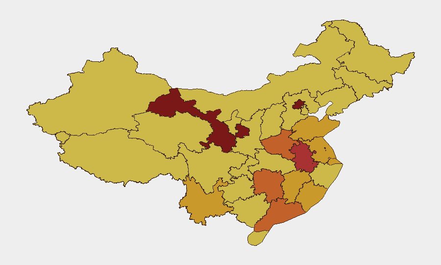
Gansu Province leads sub-national rankings (risk score 100), followed by Beijing (85.2) and Anhui (77), but current acute risk is concentrated in flood-affected southern and northeastern zones not yet fully reflected in the composite indices. Guangxi, Liaoning, and Chongqing face the most immediate hazards from ongoing typhoon, flooding, reservoir failures, and landslides. Northern and central provinces (Henan, Hunan, Shandong, Jiangsu) carry elevated structural risk (scores 72–74) but no acute incidents in the last 48 hours.
How GeoBit Would Assist
Teams with personnel or assets in flood-affected regions should activate AOI Monitoring & Early Warning for Guangxi, Liaoning, and Chongqing to track evolving flood, landslide, and infrastructure-damage reports in real time. Satellite & Imagery analysis can verify reservoir damage, assess infrastructure disruption, and estimate displacement; GIS & Spatial Analysis and Routing & Network Analysis support alternative journey planning around blocked roads and flooded transport corridors. Intel Sweep and multi-language OSINT fusion provide rapid corroboration of casualty figures and emergency-response effectiveness, critical for duty-of-care assessments and evacuation decision-making.
7-Day Outlook
Typhoon Maysak impacts will persist over the next 5–7 days, with heavy rainfall continuing across southern and northeastern provinces and additional geological hazards (landslides, flooding) likely. Casualty and displacement figures may be revised upward as search and rescue operations conclude and damage assessments complete. No imminent political, civil-unrest, or military escalation is forecast; risk remains weather-driven.
Highest-Risk Areas — Ranked
| # | State / Region | Risk |
|---|---|---|
| 1 | Gansu | 100 |
| 2 | Beijing | 85.2 |
| 3 | Anhui | 77 |
| 4 | Henan | 73.8 |
| 5 | Hunan | 73.5 |
| 6 | Guangdong Province | 73.4 |
| 7 | Shanghai | 72.8 |
| 8 | Shandong | 72.8 |
| 9 | Jiangxi | 72.2 |
| 10 | Jiangsu | 72 |
| 11 | Yunnan | 71.3 |
| 12 | Fujian | 71.1 |
Sources
Previous Daily Briefs
A new China brief is written every day — each with its own risk map and downloadable CSV. Here's the last week; use the calendar to go further back.
📅 Browse every day by calendar →
Highlighted days have a brief. Tap a day for that day's map & analysis, or “csv” for that day's dataset ($5).
Atlas — our AI intelligence desk — emails them this snapshot personally. Nothing else, no list.