Situation Summary
Cyprus maintains an elevated threat profile (rank #127 globally, composite score 5/10) driven primarily by concentrated risks in the divided northern territory and long-standing geopolitical fault lines. Recent event signals indicate diplomatic friction—notably expulsion/deportation activity involving Haryana (India) and Cyprus, energy-sector statements, and unspecified conventional military force activity in Nicosia—but the overall trajectory remains one of managed tension rather than acute escalation. Threat activity is heavily concentrated in the northern occupied territories (Nicosia, Famagusta, Kyrenia), while southern and western districts (Limassol, Paphos) retain substantially lower risk profiles. No credible open-source incident reports of significant security events in the last 24–48 hours have been independently verified.
Key Developments
Open-source reporting accessible within the last 24–48 hours does not contain independently time-stamped, cross-verified incidents meeting brief standards for recency and specificity. GeoBit event signals indicate activity clusters around:
- Diplomatic expulsion activity (Haryana ↔ Cyprus, 13–14 June) — context and operational impact unclear from available reporting
- Energy Ministry public statement vs. Houston-based entity (13 June, Nicosia region) — commercial or bilateral tone unconfirmed
- Conventional military force reference, Nicosia (13 June) — no detail on drill, movement, or alert status available
- UK–warship rejection event (12 June, location/context unconfirmed in current reporting)
Assessment: These signals likely reflect diplomatic routing, commercial disputes, or routine military posturing rather than acute security incidents. Verification against local Cypriot media, police statements, or transport/NOTAM feeds is recommended before operational response.
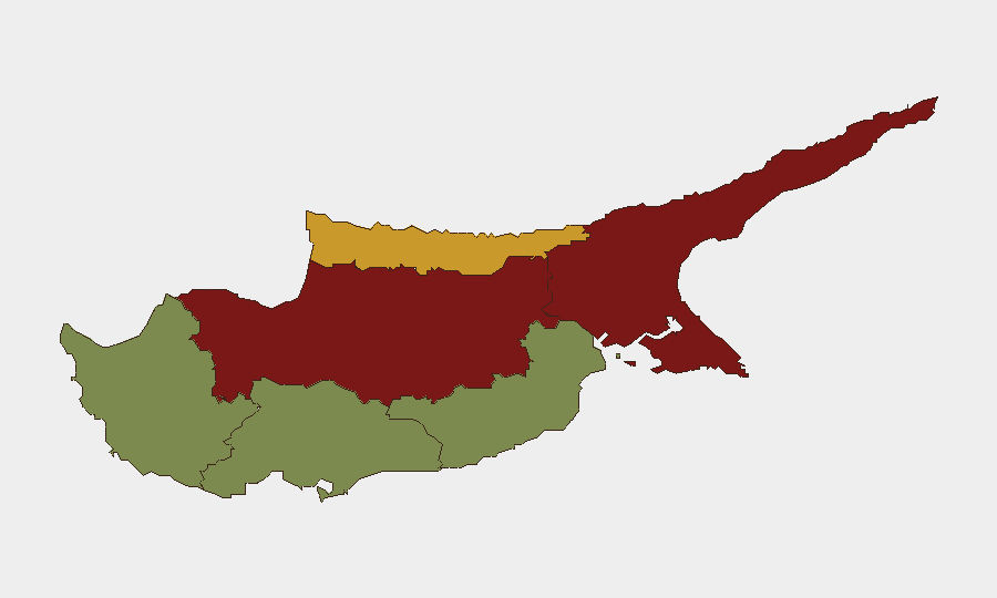
Highest-Risk Areas
Nicosia (risk 92) and Famagusta (risk 88) dominate the threat landscape, reflecting their location in the Turkish-occupied north and their centrality to the unresolved partition. Kyrenia (risk 72) follows, driven by the same geopolitical exposure and proximity to maritime boundaries. The contrast with Larnaca (risk 28), Limassol (risk 22), and Paphos (risk 18)—all in the Republic-controlled south—reflects the concentration of structural military presence, intercommunal sensitivities, and international-incident history in the north. Organizations with personnel or assets in Nicosia and Famagusta should apply heightened vetting, movement protocols, and incident-response procedures. Southern operations remain considerably lower-risk but warrant standard duty-of-care monitoring.
How GeoBit Would Assist
Security teams managing Cyprus exposure should deploy AOI Monitoring & Early Warning on Nicosia and Famagusta with real-time alerting on military, diplomatic, and cross-border activity; Intel Sweep (global event feeds, X/Twitter & Telegram OSINT, multi-language search) for rapid confirmation and context of emerging signals; and Routing & Network Analysis for contingency movement planning in high-risk districts. Satellite & Imagery analysis and Maritime & Aviation tracking provide situational awareness of military posture and cross-border movement. Conflict & Military (battle mapping, force structure) capabilities support understanding of Turkish and Cypriot deployment patterns and flashpoint vulnerability.
7-Day Outlook
No indicators suggest imminent escalation above the current baseline of diplomatic friction and structural partition-related tensions. Haryana expulsion activity and energy-sector disputes appear bilateral and routine. Monitoring should remain focused on Turkish military posture (historical flashpoint), maritime boundary incidents, and any expansion of conventional force signaling in Nicosia. Standard vigilance protocols remain appropriate across all operational areas.
Highest-Risk Areas — Ranked
| # | State / Region | Risk |
|---|---|---|
| 1 | Nicosia | 92 |
| 2 | Famagusta | 88 |
| 3 | Kyrenia | 72 |
| 4 | Larnaca | 28 |
| 5 | Limassol | 22 |
| 6 | Paphos | 18 |
Sources
Previous Daily Briefs
A new Cyprus brief is written every day — each with its own risk map and downloadable CSV. Here's the last week; use the calendar to go further back.
📅 Browse every day by calendar →
Highlighted days have a brief. Tap a day for that day's map & analysis, or “csv” for that day's dataset ($5).