Situation Summary
Dominica maintains a stable, low-incident security environment as of 24 August 2026, with no discrete civil unrest, major crime spikes, acute political instability, or infrastructure failures documented in open reporting over the past 24–48 hours. The country's composite threat score of 2 and ranking at #186 globally reflect a baseline of routine governance and public order. No verified event signals or elevated alerts are currently active.
Key Developments
No discrete security, crime, civil unrest, political instability, or infrastructure incidents have been confirmed in Dominica during the 24–48-hour window of 23–24 August 2026 via available open sources and real-time monitoring.
Context (outside current window): A police-custody murder investigation involving two Dominica Police Service officers charged in connection with the death of teenager Jerbiah Paul (body located near Capuchin) was formally actioned around 18–21 August. This case may remain a focal point for public and media scrutiny but has not generated reported secondary incidents (protests, unrest, or additional charges) as of 24 August. Separately, prolonged power outages affecting multiple parishes occurred 14–15 August and were attributed to geothermal plant disruptions and weather; restoration efforts and utility apologies followed by 19 August and do not carry current operational implications.
Routine environmental monitoring shows high UV indices (9–10) across the region including Roseau on 23–24 August but no earthquake, volcanic activity, or severe weather alerts specific to Dominica.
Highest-Risk Areas
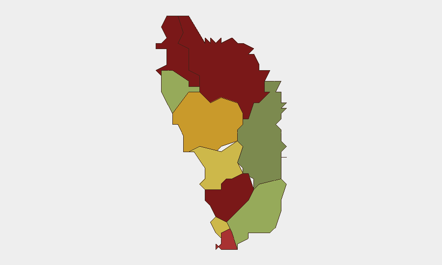
Saint Andrew Parish (risk 92) and Saint John Parish (risk 88) rank as the two highest-risk sub-national zones, followed by Saint George (81) and Saint Mark (78). This concentration in four northern and central parishes suggests that localized factors—whether petty crime, gang activity, informal settlements, or socioeconomic stress—are the primary drivers of elevated composite scores, though none have escalated into current discrete incidents. Southern parishes (Saint Patrick, 48; Saint David, 35) report substantially lower risk, indicating geographical clustering of vulnerability rather than island-wide instability.
How GeoBit Would Assist
Corporate security and duty-of-care teams with personnel or assets in Dominica would benefit from persistent AOI (Area-of-Interest) monitoring and alerting on the four highest-risk parishes to capture early signals of civil unrest, organized activity, or crime spikes before they broaden. OSINT fusion and corroboration across local police statements, social media, and community channels would detect secondary impacts from the ongoing police-custody investigation that may not yet appear in international reporting. Risk and threat assessment capabilities—refreshed weekly or on-demand—would enable rapid re-ranking of parish-level exposure as conditions shift, ensuring duty-of-care protocols remain calibrated to actual, not historical, risk.
7-Day Outlook
No indicators suggest imminent escalation in Dominica's security posture over the next seven days. The resolution or adjudication of the police-custody case over coming weeks may generate localized media and community interest but is unlikely to trigger island-wide civil unrest given the country's institutional stability and low baseline threat environment. Routine monitoring for secondary crime trends and infrastructure resilience (particularly power and water utilities) remains prudent but not urgent.
Highest-Risk Areas — Ranked
| # | State / Region | Risk |
|---|---|---|
| 1 | Saint Andrew Parish | 92 |
| 2 | Saint John Parish | 88 |
| 3 | Saint George Parish | 81 |
| 4 | Saint Mark Parish | 78 |
| 5 | Saint Joseph Parish | 72 |
| 6 | Saint Paul Parish | 68 |
| 7 | Saint Luke Parish | 62 |
| 8 | Saint Peter Parish | 55 |
| 9 | Saint Patrick Parish | 48 |
| 10 | Saint David Parish | 35 |
Sources
Previous Daily Briefs
A new Dominica brief is written every day — each with its own risk map and downloadable CSV. Here's the last week; use the calendar to go further back.
- August 21, 2026
- August 18, 2026
- August 16, 2026
- August 14, 2026
- August 12, 2026
- August 10, 2026
- August 8, 2026
📅 Browse every day by calendar →
Highlighted days have a brief. Tap a day for that day's map & analysis, or “csv” for that day's dataset ($5).
Atlas — our AI intelligence desk — emails them this snapshot personally. Nothing else, no list.