Situation Summary
East Timor remains stable with no acute security incidents reported in the last 24–48 hours. The country is ranked #null globally (composite threat score 3) with zero tracked events in the current assessment window. Diplomatic and economic engagement (UN Security Council participation, regional ASEAN forums, gas-sector cooperation with Australia) is proceeding normally. The security environment shows no indicators of imminent destabilization, though sub-national risk variance—particularly in Dili and coastal western districts—warrants continued baseline monitoring.
Key Developments
- Dili – 11 June 2026 – Timor‑Leste delivered remarks at the UN Security Council debate on political mediation and dialogue; diplomatic engagement abroad, no domestic instability signaled.
- National – Early June 2026 – Timor‑Leste participated in ASEAN Inter-Parliamentary Assembly regional cooperation sessions on peace and security; routine regional integration activity.
- National – Pre-June (ongoing) – Asian Development Bank road-infrastructure upgrade project continues; climate-resilience improvement to national highway network, no disruptions reported.
- No reported security incidents, civil unrest, criminal activity targeting foreigners, infrastructure failures, or political instability in the last 48 hours across monitored open-source channels (news, social media, sector reports).
Highest-Risk Areas
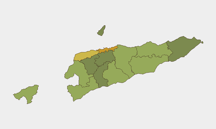
Dili (risk 72) and the western coastal districts of Liquiçá (62) and Baucau (58) carry the highest composite risk scores nationally. These concentrations reflect historical patterns of gang activity, inter-communal tensions, and petty crime rather than active conflict or terrorism. Dili, as the capital and largest urban center, concentrates both population density and criminal opportunity; Liquiçá and Baucau have reported communal dispute backgrounds and isolated youth violence. The risk gradient falls steeply inland and eastward; rural and eastern districts (Aileu, Ermera, Manatuto) show substantially lower scores. Security teams with personnel in Dili should prioritize situational awareness in peripheral neighborhoods and transport security; western districts warrant standard vigilance appropriate to urban-frontier crime patterns.
How GeoBit Would Assist
Teams should employ AOI Monitoring & Early Warning on Dili and Liquiçá to detect any uptick in protest activity, gang mobilization, or crime clusters before they escalate; OSINT Fusion (X/Twitter, local media, sector intelligence) to maintain real-time visibility on political statements, civil-society messaging, and crime reporting; and Routing & Network Analysis to pre-plan secure transit corridors and alternative routes away from high-risk neighborhoods for personnel movement. Sentiment & Temporal Analysis on social and news feeds will flag emerging tensions or organized action before broad unrest materializes.
7-Day Outlook
No escalation is anticipated in the next seven days absent external shocks (major regional geopolitical events, commodity-price crises affecting state revenue, or spillover from maritime disputes). Routine governance, economic activity, and regional engagement should continue. Security posture should remain steady-state: baseline street-crime vigilance in urban areas, standard duty-of-care protocols for expatriate staff, and continued low-level monitoring of political rhetoric and labor/communal disputes in western districts.
Highest-Risk Areas — Ranked
| # | State / Region | Risk |
|---|---|---|
| 1 | Dili | 72 |
| 2 | Liquiçá | 62 |
| 3 | Baucau | 58 |
| 4 | Cova Lima | 55 |
| 5 | Bobonaro | 53 |
| 6 | Oecussi-Ambeno | 48 |
| 7 | Manufahi | 45 |
| 8 | Viqueque | 42 |
| 9 | Manatuto | 40 |
| 10 | Ainaro | 38 |
| 11 | Ermera | 36 |
| 12 | Aileu | 32 |
Sources
Previous Daily Briefs
A new East Timor brief is written every day — each with its own risk map and downloadable CSV. Here's the last week; use the calendar to go further back.
📅 Browse every day by calendar →
Highlighted days have a brief. Tap a day for that day's map & analysis, or “csv” for that day's dataset ($5).