Situation Summary
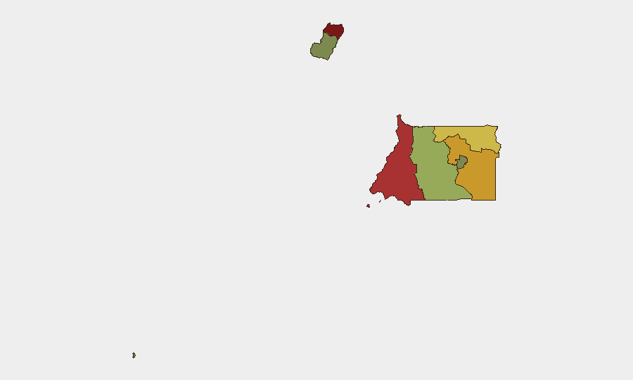
Equatorial Guinea presents a low-intensity threat environment with no verified security incidents, civil unrest, or infrastructure disruptions reported in the last 24–48 hours. Sub-national risk concentrations remain in Bioko Norte and Litoral Province, driven by historical patterns of military activity and border-proximity factors rather than acute current events. Overall national threat trajectory remains stable, with no indicators of imminent escalation.
Key Developments
Open-source intelligence collection in the last 24–48 hours has not identified cross-verified security, crime, political instability, or travel-risk events in Equatorial Guinea meeting recency and reliability thresholds. Major news outlets, official channels, and geolocated social media provide sparse, near-real-time coverage of the country. Consequently, specific timestamped incident reporting for this window is not available.
Background context (not current developments):
- Military activity signals and regional posturing between external powers (e.g., Guam–China dynamics) are tracked globally but do not appear to have direct operational impact on Equatorial Guinea's domestic security posture as of this date.
- Bioko Norte and Litoral Province have historically registered elevated risk scores; monitoring these zones remains relevant for duty-of-care planning.
Highest-Risk Areas
Bioko Norte (risk 85) and Litoral Province (risk 78) dominate the sub-national threat landscape, likely reflecting a combination of military infrastructure presence, cross-border dynamics with Cameroon and Gabon, and historical patterns of state security activity. Wele-Nzas and Kié-Ntem Provinces (risks 72 and 68 respectively) also warrant attention due to their border exposure and lower administrative capacity. Central and island provinces show materially lower risk, with Djibloho (the new capital administrative zone) and Annobón Province at the lower end of the national spectrum.
How GeoBit Would Assist
Corporate security teams should leverage AOI Monitoring & Early Warning on Bioko Norte and Litoral to detect sudden shifts in military or administrative activity. OSINT fusion (social media, radio SIGINT, multi-language search, and entity extraction) combined with sentiment & temporal analysis can identify emerging civil unrest, labor disputes, or public grievances before they escalate. Routing & Network Analysis supports contingency planning for personnel movement, particularly across Bioko Island and between the mainland provinces, should local conditions deteriorate.
7-Day Outlook
No acute security triggers are evident for the immediate week ahead. Risk levels are expected to remain stable provided no external regional shocks (e.g., escalation in Gulf of Guinea maritime incidents, Cameroon–Gabon border friction) directly affect Equatorial Guinea's security posture. Routine monitoring of Bioko Norte and Litoral Province should continue as a precautionary baseline.
Note: This brief reflects available open-source intelligence as of 2026-06-20. Equatorial Guinea receives limited mainstream media and social-media coverage; absence of reported incidents does not confirm absence of risk. Organizations with personnel or assets in-country should supplement this assessment with on-the-ground reporting, diplomatic contacts, and peer-company intelligence sharing.
Highest-Risk Areas — Ranked
| # | State / Region | Risk |
|---|---|---|
| 1 | Bioko Norte | 85 |
| 2 | Litoral Province | 78 |
| 3 | Wele-Nzas Province | 72 |
| 4 | Kié-Ntem Province | 68 |
| 5 | Centro Sur Province | 45 |
| 6 | Bioko Sur | 38 |
| 7 | Djibloho | 15 |
| 8 | Annobón Province | 8 |
Previous Daily Briefs
A new Equatorial Guinea brief is written every day — each with its own risk map and downloadable CSV. Here's the last week; use the calendar to go further back.
📅 Browse every day by calendar →
Highlighted days have a brief. Tap a day for that day's map & analysis, or “csv” for that day's dataset ($5).