Situation Summary
Eritrea remains a low-frequency threat environment (global rank #79, composite score 24) with no confirmed security incidents recorded in the past seven days. The country's threat profile is shaped primarily by geographic proximity to Red Sea shipping disruptions and internal governance constraints rather than active armed conflict or widespread civil unrest. A significant bilateral policy shift—U.S. sanctions removal on September 18–19—has reduced immediate external pressure on the Eritrean government but does not alter underlying security conditions on the ground.
Key Developments
- September 18, 2026 — Washington, D.C.: The United States allowed its 2021 national emergency declaration on Eritrea to expire and delisted the Eritrean Defense Forces, the People's Front for Democracy and Justice, the Hidri Trust, the Red Sea Trading Corporation, and two Eritrean officials from sanctions designations. U.S. officials attributed the move to advancing regional interests amid Red Sea security priorities.
- September 19, 2026 — Asmara: Eritrean Information Minister Yemane Gebremeskel publicly welcomed the U.S. sanctions removal, framing it as an opportunity to deepen bilateral cooperation in investment and trade.
- September 16–22, 2026 — Red Sea / Regional: The sanctions policy change generated renewed strategic attention to Eritrea's geopolitical role in the Bab el-Mandeb Strait and surrounding maritime corridor, particularly in relation to shipping security near Yemen. No confirmed security incidents within Eritrea itself were identified during this window.
Highest-Risk Areas
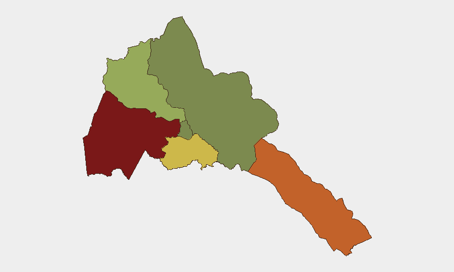
Gash-Barka (risk 92) and the Southern Red Sea Region (risk 75) represent the country's most volatile zones, though absolute incident frequency remains low. Gash-Barka's elevated risk reflects its position as a border region with limited state capacity and informal cross-border movement; the Southern Red Sea Region's score correlates with maritime exposure and proximity to regional instability. Debub Region (risk 68) ranks third, likely reflecting mixed governance and resource constraints. Maekel Region (Asmara, the capital) carries significantly lower risk (18), indicating that major urban centers and government-controlled zones remain relatively stable. Northern Red Sea Region presents negligible tracked risk (0).
How GeoBit Would Assist
Security teams with personnel or assets in Eritrea should employ AOI (Area-of-Interest) Monitoring & Early Warning on Gash-Barka and Southern Red Sea Region to detect emerging unrest, trafficking, or cross-border movement patterns before they escalate. Intel Sweep and multi-language OSINT (including Telegram and radio SIGINT) provide persistent monitoring of regime communications, official policy shifts, and unofficial networks that may signal political or security transitions. Maritime & Aviation tracking combined with Economic & Trade intelligence enable real-time visibility of Red Sea shipping corridors and sanctions-related compliance or disruption affecting supply chains and port access.
7-Day Outlook
The sanctions removal is likely to encourage expanded Eritrean engagement with Western and regional actors over the next 1–2 weeks, but will not immediately reduce structural risks in border and maritime zones. No imminent escalation of internal conflict or civil unrest is forecast; the threat environment remains characterized by chronic governance constraints and geographic exposure rather than acute crisis. Duty-of-care teams should monitor for any shifts in Eritrean military posture toward the Red Sea and track bilateral U.S.–Eritrea engagement milestones that may affect visa, trade, or security cooperation protocols.
Highest-Risk Areas — Ranked
| # | State / Region | Risk |
|---|---|---|
| 1 | Gash-Barka | 92 |
| 2 | Southern Red Sea Region | 75 |
| 3 | Debub Region | 68 |
| 4 | Anseba | 55 |
| 5 | Maekel Region | 18 |
| 6 | Northen Red Sea Region | 0 |
Sources
Previous Weekly Briefs
A new Eritrea brief is written every Monday, covering the week — each with its own risk map and downloadable CSV. Use the calendar to go further back.
- September 15, 2026
- September 8, 2026
- September 2, 2026
- August 31, 2026
- August 29, 2026
- August 27, 2026
- August 25, 2026
📅 Browse past briefs by calendar →
Highlighted days have a brief. Tap a day for that day's map & analysis, or “csv” for that day's dataset ($5).
Atlas — our AI intelligence desk — emails them this snapshot personally. Nothing else, no list.