Situation Summary
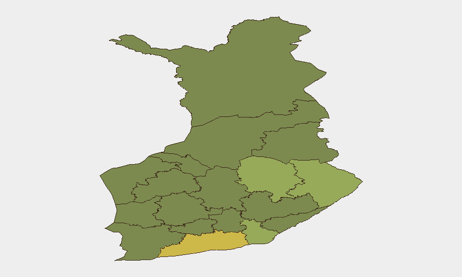
Finland remains a low-threat environment with a composite threat score of 5 globally and no systemic security deterioration reported. Sub-national risk concentration is evident in Uusimaa (Helsinki metropolitan region), which accounts for nearly half of tracked signals, alongside heightened activity in North Karelia and Kymenlaakso. The current security posture reflects routine civil incident management rather than acute national or regional instability.
Key Developments
- 2026-07-24, nationwide: Fire service issued public statement; nature and location of statement not yet corroborated by secondary sources.
- 2026-07-25, Finland–Sweden border region: Threat signal registered between Finland and Sweden; underlying cause and specific location pending verification.
- 2026-07-25, unspecified location: Ukrainian national or organization issued public statement; content and relevance to Finland security not yet confirmed.
- Recent, location unconfirmed: Flood event (ID 1104008) tracked in Finland; severity, regional impact, and current status require geolocation verification.
- Helsinki city center, weekend context: Pride parade scheduled with traffic management measures; no security incident reported, but event-related crowd management and traffic disruption expected.
- Southern Finland, weekend: Heatwave forecast concurrent with festival activity; relevant to casualty risk and emergency service load rather than security threat.
*Note: Limited corroboration from live web research. Finnish police newsroom reports no updated incident notifications as of briefing time.*
Highest-Risk Areas
Uusimaa (risk score 65) dominates the risk landscape, reflecting Helsinki's role as the national capital, transport hub, and population center; the concentration of government, finance, and critical infrastructure in the region naturally elevates signal density and exposure. Secondary risk clusters in North Karelia (44) and Kymenlaakso (42)—both bordering Russia—are consistent with historical border-region monitoring patterns and routine cross-border activity. North Savo and South Karelia follow; the eastern and southeastern corridor accounts for approximately 60% of Finland's tracked risk signal. Western and central regions (Southwest Finland, Central Finland, Pirkanmaa) show markedly lower risk profiles, typical of lower-population-density and lower-infrastructure-concentration areas.
How GeoBit Would Assist
Intel Sweep and OSINT Fusion would rapidly corroborate the four pending signals (fire statement, Finland–Sweden threat, Ukrainian statement, flood event) across open sources, news feeds, and social media to isolate confirmed incidents from context-only mentions. AOI Monitoring & Early Warning on Uusimaa, North Karelia, and Kymenlaakso would provide persistent watch on high-risk regions and alert on material changes in threat posture or event velocity. GIS & Spatial Analysis and Satellite & Imagery analysis would geolocate the flood event, assess infrastructure impact, and forecast cascading effects on duty-of-care operations.
7-Day Outlook
No material escalation is forecast over the next seven days. Routine summer event management (Pride parade, festivals) and weather-related impacts (heatwave, flood recovery) will dominate operational priorities. The Finland–Sweden signal and fire service statement warrant 24–48 hour follow-up to rule out cross-border incidents or infrastructure damage; absent corroboration, the overall threat trajectory remains stable.
Highest-Risk Areas — Ranked
| # | State / Region | Risk |
|---|---|---|
| 1 | Uusimaa | 65 |
| 2 | North Karelia | 44 |
| 3 | Kymenlaakso | 42 |
| 4 | North Savo | 40 |
| 5 | South Karelia | 38 |
| 6 | Kainuu | 36 |
| 7 | Päijät-Häme | 35 |
| 8 | South Savo | 32 |
| 9 | Kanta-Häme | 30 |
| 10 | Pirkanmaa | 28 |
| 11 | Central Finland | 26 |
| 12 | Southwest Finland | 25 |
Sources
Previous Daily Briefs
A new Finland brief is written every day — each with its own risk map and downloadable CSV. Here's the last week; use the calendar to go further back.
📅 Browse every day by calendar →
Highlighted days have a brief. Tap a day for that day's map & analysis, or “csv” for that day's dataset ($5).
Atlas — our AI intelligence desk — emails them this snapshot personally. Nothing else, no list.