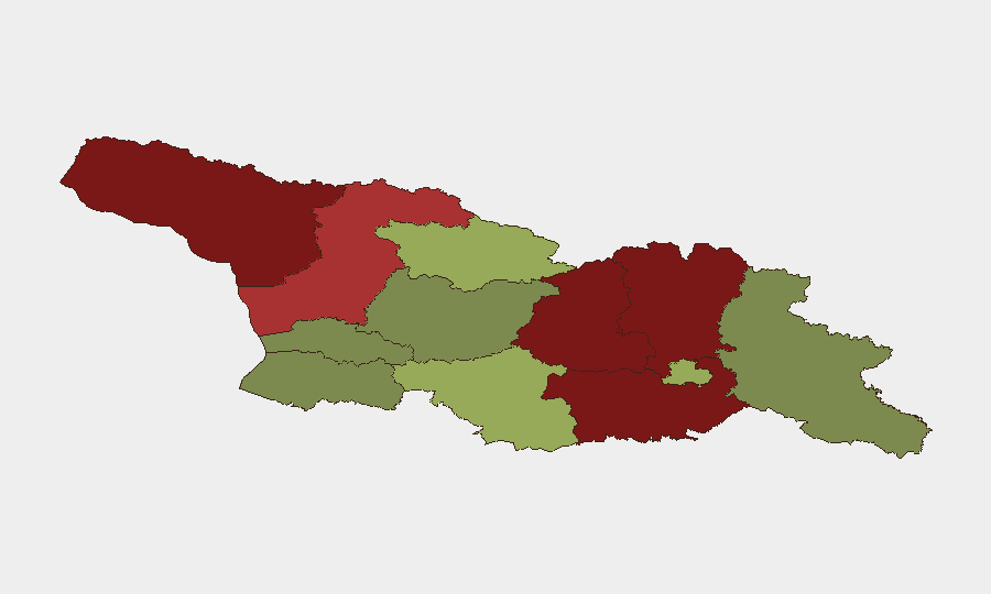
Situation Summary
Georgia maintains a composite threat score of 2.1 (rank #148 globally) with 11 tracked events as of 2026-06-10. The security environment is dominated by ongoing tensions in breakaway territories and border regions, particularly Abkhazia and South Ossetia (Shida Kartli), where military activity and investigation-level signals have been recorded in the past 72 hours. Recent flooding has also introduced infrastructure and displacement risks across multiple regions. Overall threat posture remains elevated in the north and central regions but manageable in most urban and southern zones.
Key Developments
- 2026-06-07, Northern border region: Conventional military force activity involving SURGEON asset and St Petersburg entity recorded; specific tactical details and locations require further corroboration.
- 2026-06-09, Investigation alert: Two separate investigation-level signals tied to SURGEON asset; nature and geographic specificity of incidents remain unclear pending open-source confirmation.
- 2026-06-08, U.S. diplomatic signal: Disapproval statement recorded involving George W. Bush entity and United States; indirect bearing on U.S. interests or policy stance toward Georgia.
- Recent, multi-regional: Active flooding event (reference ID 1103909) affecting Georgia; impacts to transportation, power, and civilian access in flood-prone areas (typically Imereti, Racha-Lechkhumi, and lower-elevation zones).
*Note: Real-time web research confirms flood event; military and investigation signals require independent verification via news, official statements, or diplomatic channels.*
Highest-Risk Areas
Abkhazia (risk 95) and Shida Kartli/Lower Kartli (risk 88–85) remain by far the highest-risk zones, driven by unresolved territorial disputes, proximity to Russian military presence, and recurrent military signaling. These de facto autonomous regions are effectively outside Georgian state control and experience episodic armed activity and checkpoint intensification. Mtskheta-Mtianeti (risk 82) and Samegrelo-Upper Svaneti (risk 78) follow, reflecting cross-border tensions and difficult terrain that complicates civilian access and emergency response. In contrast, Tbilisi (risk 45), Imereti (risk 32), and Guria (risk 28) present significantly lower baseline risk, though current flooding may temporarily elevate localized hazards in Imereti and neighboring zones.
How GeoBit Would Assist
AOI Monitoring & Early Warning with persistent watch over breakaway territories and border crossings (Abkhazia, South Ossetia, Russian border) enables 24/7 detection of military movement, checkpoint activity, and civilian displacement. Conflict & Military tools (force structure, weapons-capability tracking, battle mapping) provide early indication of escalation or de-escalation in armed activity. OSINT Fusion & Corroboration (multi-language search, X/Twitter & news feed analysis, entity extraction) rapidly cross-validates military and diplomatic signals with independent open sources, reducing false alarms and clarifying intent. GIS & Spatial Analysis and Satellite & Imagery analysis pinpoint flooding impact zones and support alternative routing for personnel and supply convoys around affected infrastructure.
7-Day Outlook
Military signaling in the north shows no immediate signs of sharp escalation, but the investigation-level alerts warrant continued monitoring through diplomatic and OSINT channels. Flooding recovery will likely dominate civilian risk posture over the next week, with road closures and utility disruptions most acute in central and western regions. Risk profile is expected to remain stable in Tbilisi and southern regions; no major scheduled events or geopolitical inflection points are flagged.
Highest-Risk Areas — Ranked
| # | State / Region | Risk |
|---|---|---|
| 1 | Autonomous Republic of Abkhazia | 95 |
| 2 | Shida Kartli | 88 |
| 3 | Lower Kartli | 85 |
| 4 | Mtskheta-Mtianeti | 82 |
| 5 | Samegrelo-Upper Svaneti | 78 |
| 6 | Samtskhe-Javakheti | 48 |
| 7 | Tbilisi | 45 |
| 8 | Racha-Lechkhumi and Kvemo Svaneti | 42 |
| 9 | Kakheti | 38 |
| 10 | Autonomous Republic of Adjara | 35 |
| 11 | Imereti | 32 |
| 12 | Guria | 28 |
Sources
Previous Daily Briefs
A new Georgia brief is written every day — each with its own risk map and downloadable CSV. Here's the last week; use the calendar to go further back.
📅 Browse every day by calendar →
Highlighted days have a brief. Tap a day for that day's map & analysis, or “csv” for that day's dataset ($5).