Situation Summary
Ghana remains a relatively stable operating environment in West Africa, ranked #61 globally with a composite threat score of 3.0 across 38 tracked events. No acute security incidents—riots, armed clashes, major crime spikes, or infrastructure disruptions—have been reported in the last 24–48 hours. The security baseline is characterized by low-level urban crime concentrated in Accra, routine road-safety hazards, and limited civil unrest, with no indication of imminent destabilization.
Key Developments
- 9–10 June · Accra: Government policy activity centered on cyber-security and digital governance. The Minister for Communication and Digital Technology addressed the opening of the ECOWAS Regional Hackathon, emphasizing cyber-crime prevention and digital-policy alignment across the region. No operational or physical-security incidents reported.
- 9–10 June · Nationwide: President John Dramani Mahama issued public statements on economic development, ECOWAS cooperation, and visa/mobility initiatives. These reflect routine diplomatic and economic messaging; no crisis or unrest indicators present.
- Persistent open-source signal: Online discourse regarding a proposed regulatory requirement for ID verification on adult websites in Ghana, framed as child-protection policy. This represents regulatory activity, not an immediate security incident.
- Background context (pre-24–48 hour window): The sequence of "Investigate," "Reject," and "Public Statement" event signals logged 8–9 June involved government, police, and ministerial actors; specific incident details remain unclear from available open sources. These do not map to corroborated civil unrest, crime events, or travel disruptions in the current brief window.
No reports of mass protests, terrorist incidents, armed robbery clusters, kidnappings, or service failures impacting traveler or staff safety have surfaced in Ghana's major cities or transportation corridors in the last two days.
Highest-Risk Areas
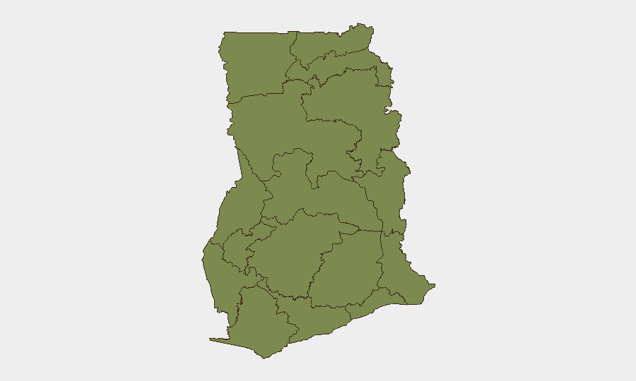
Greater Accra Region dominates the sub-national risk profile (32.1), driven primarily by concentration of urban crime—petty theft, armed robbery in high-density and commercial zones, and occasional gang activity—rather than by political instability or armed conflict. Bono East Region (20.4) and Ashanti Region (12.1) show elevated risk signals; Bono East's score likely reflects illicit-gold-mining activity and associated labor disputes, while Ashanti's reflects similar resource-competition dynamics and urban-crime concentration in Kumasi. Northern Region (7.1) carries residual risk from cross-border trafficking and occasional communal disputes but does not show acute conflict escalation. All other regions remain substantially below 5.0, indicating low-frequency incident profiles.
How GeoBit Would Assist
Security teams with operations or personnel in Ghana should use AOI Monitoring & Early Warning to track Accra, Kumasi, and Takoradi for real-time alerts on civil unrest, labor actions, or crime-pattern shifts; OSINT fusion and multi-language search to monitor Ghanaian news outlets, X/Telegram, and government channels for policy changes (visas, curfews, sector restrictions) affecting duty of care; and Routing & Network Analysis to maintain updated alternative-transport and evacuation pathways, particularly in Greater Accra and Ashanti regions where urban congestion compounds security response times.
7-Day Outlook
Ghana's security environment is forecast to remain stable over the next seven days absent external regional shocks (e.g., spillover from Sahel instability or ECOWAS political crises). Ongoing cyber-policy and digital-governance initiatives may produce further regulatory announcements but carry no direct physical-security implication. Standard baseline precautions—awareness of petty-crime hotspots in Accra, adherence to curfew protocols if declared, and monitoring of port/transport services—remain appropriate for all corporate operations.
Highest-Risk Areas — Ranked
| # | State / Region | Risk |
|---|---|---|
| 1 | Greater Accra Region | 32.1 |
| 2 | Bono East Region | 20.4 |
| 3 | Ashanti Region | 12.1 |
| 4 | Northern Region | 7.1 |
| 5 | Volta Region | 3.8 |
| 6 | Central Region | 3.8 |
| 7 | Upper East Region | 2.1 |
| 8 | Upper West Region | 2.1 |
| 9 | Savannah Region | 2.1 |
| 10 | North East Region | 2.1 |
| 11 | Eastern Region | 2.1 |
| 12 | Oti Region | 2.1 |
Sources
Previous Daily Briefs
A new Ghana brief is written every day — each with its own risk map and downloadable CSV. Here's the last week; use the calendar to go further back.
📅 Browse every day by calendar →
Highlighted days have a brief. Tap a day for that day's map & analysis, or “csv” for that day's dataset ($5).