Situation Summary
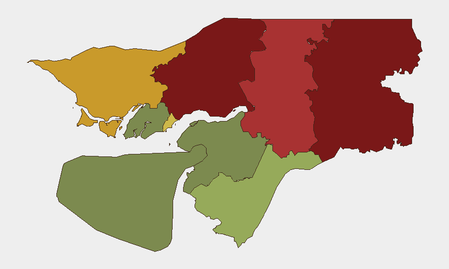
Guinea-Bissau presents a composite threat environment characterized by significant sub-national fragmentation and elevated risk concentrated in northern and central regions. The country ranks outside the global top tier for overall instability (composite score 40), but internal disparities are acute: Gabu Region (92) and Oio Region (85) pose substantially higher risk than coastal and southern areas. Recent event signals include military and security actions in neighboring Guinea, Mali, and Niger, which carry potential spillover implications for cross-border stability and trafficking corridors.
Key Developments
Data Limitation Notice: Available event signals from the last 24–48 hours do not contain verifiable, dated incidents specific to Guinea-Bissau territory. Recent signals predominantly reference neighboring states (Guinea, Mali, Niger, Papua New Guinea) and do not confirm active armed clashes, arrest operations, or security incidents within Guinea-Bissau proper as of 2026-06-20. A single social-media reference to "Military Officers Seize Power in Guinea-Bissau" and "Security tightened after UN and US terror warnings" lacks publication date, source verification, and sufficient detail to confirm current status. No fresh tactical developments can be responsibly reported without additional corroborated intelligence.
Highest-Risk Areas
Gabu and Oio regions (northeastern border zone) drive the country's sub-national risk profile, with composite scores of 92 and 85 respectively. These areas share porous, under-resourced borders with Guinea and Senegal, creating environments conducive to cross-border criminal networks, trafficking, and armed-group mobility. Bafatá (78) and Cacheu (72) extend this risk corridor through the center-north. By contrast, Bolama Island (15) and Biombo (32) remain substantially lower-risk. The capital region (Bissau Autonomous Sector, 68) occupies mid-tier risk, reflecting governance and urban-crime pressures but relative institutional presence. Northern concentration suggests Guinea-Bissau's primary vulnerabilities lie in territorial control and customs enforcement rather than capital-based state collapse.
How GeoBit Would Assist
Security and risk teams operating in Guinea-Bissau should prioritize AOI Monitoring & Early Warning focused on Gabu and Oio regions to detect cross-border movement, trafficking activity, and armed-group presence with persistent alerting. OSINT Fusion & Corroboration (X/Telegram, multi-language news, event feeds) applied to border towns and military checkpoints will establish ground truth on recent coup rumors and security-force posture. Routing & Network Analysis can identify safe corridors and alternative movement paths through high-risk northern regions, while Conflict & Military force-structure tracking will clarify Guinea's and Mali's military positioning relative to Guinea-Bissau's borders and spillover risk.
7-Day Outlook
No imminent large-scale destabilization is evident from current signals, but the absence of verified recent incidents does not exclude fluid tactical developments in remote northern zones. Neighboring military activity (Guinea, Mali, Niger) warrants close monitoring for refugee flows, arms movement, or armed-group repositioning across Guinea-Bissau's northern frontier. Teams should maintain heightened situational awareness in Gabu and Oio and request fresh OSINT sweeps to clarify the status of reported security measures and any political transitions.
Highest-Risk Areas — Ranked
| # | State / Region | Risk |
|---|---|---|
| 1 | Gabu Region | 92 |
| 2 | Oio Region | 85 |
| 3 | Bafatá Region | 78 |
| 4 | Cacheu Region | 72 |
| 5 | Bissau Autonomous Sector | 68 |
| 6 | Tombali Region | 45 |
| 7 | Quinara Region | 38 |
| 8 | Biombo Region | 32 |
| 9 | Bolama Region | 15 |
Previous Daily Briefs
A new Guinea-Bissau brief is written every day — each with its own risk map and downloadable CSV. Here's the last week; use the calendar to go further back.
📅 Browse every day by calendar →
Highlighted days have a brief. Tap a day for that day's map & analysis, or “csv” for that day's dataset ($5).