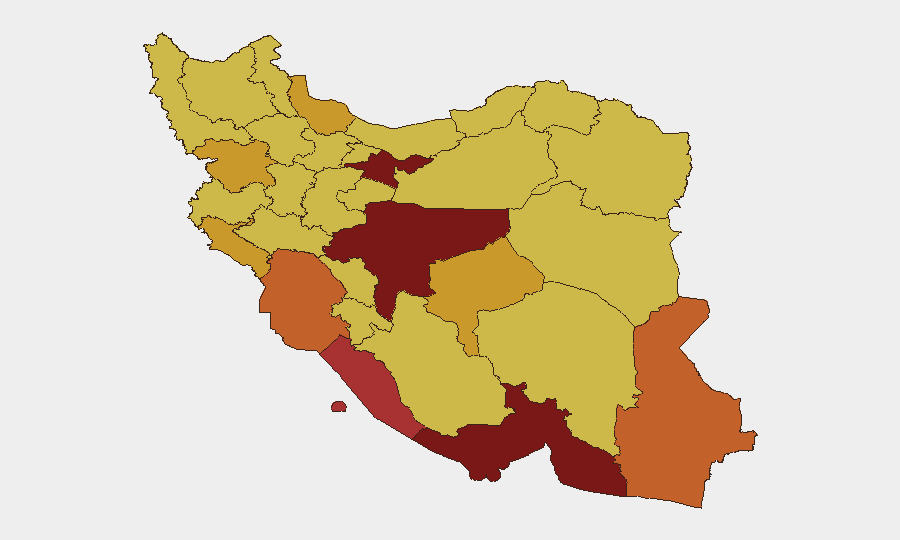
Situation Summary
Iran is experiencing an acute military crisis following six consecutive nights of U.S. airstrikes (15–16 July 2026) targeting coastal defense systems, military infrastructure, ports, and transportation links across the southern and southwestern provinces. The Strait of Hormuz remains under Iranian closure declarations, with reported hostile Iranian actions against commercial shipping alongside U.S. strikes on Iranian maritime assets. The composite threat environment reflects simultaneous conventional military escalation, internal state instability signals (disapproval statements from Tehran and Ministry bodies), and regional involvement by Gulf Arab states and Israel, positioning Iran as the fifth-highest global threat environment.
Key Developments
- Bandar Abbas, Hormozgan Province (16 July): U.S. airstrikes struck targets in and around the major port city for the sixth consecutive night; Kahurestan and Gariveh bridges (key road links to Shiraz) and Bandar Abbas railway junction were damaged, disrupting southern transport corridors.
- Bushehr, Bushehr Province (16 July): U.S. strikes hit the southern port city, which hosts Iran's primary nuclear power complex; impacts confirmed by IRNA and echoed in European media coverage, raising potential nuclear-facility contamination or infrastructure risk.
- Mahshahr, Khuzestan Province (16 July): An agricultural water pumping station was struck; one guard killed and four injured reported by Iranian state media, indicating expanding civilian-infrastructure targeting.
- Iranshahr, Sistan and Baluchestan Province (16 July): Iranshahr Airport was damaged in the latest U.S. wave, further degrading southern-sector civil aviation and emergency-response capability.
- Strait of Hormuz (ongoing, 15–16 July): Iran maintained declared closure; reports indicate Iranian forces targeted or fired on commercial vessels while U.S. forces struck Iranian coastal-defense and maritime assets, creating acute risk for shipping and energy transit.
- Greater Tunb Island & Sistan and Baluchestan (night of 15–16 July): CENTCOM operations struck coastal defense systems, a missile depot on Greater Tunb Island, and two military barracks in the southeastern province, indicating sustained focus on Iran's air-denial and maritime-warfare capacity.
- Internal State Signals (14–15 July): Multiple disapproval statements from Iran, Tehran, and Ministry bodies, coupled with threats from Tehran toward military structures, suggest internal fracture or civilian-leadership dissatisfaction with military response or escalation trajectory.
Highest-Risk Areas
Tehran Province (risk 100) remains the epicenter of regime instability and decision-making vulnerability, amplified by the observed internal disapproval signals. However, the immediate operational threat is concentrated in the southern and southwestern corridor: Hormozgan (82.3), Khuzestan (75.2), and Sistan and Baluchestan (74.3) provinces are now active strike zones with damaged military, port, airport, and transportation infrastructure. Bushehr (76.4) presents additional nuclear-facility risk. This geographic band encompasses Iran's primary maritime chokepoint (Strait of Hormuz), energy infrastructure, and military-response capacity; sustained strikes here directly threaten supply chains, civilian services, and regional stability.
How GeoBit Would Assist
GeoBit's AOI Monitoring & Early Warning system should be configured on Tehran Province (regime decision nodes), the Strait of Hormuz corridor, and Bandar Abbas–Bushehr ports to detect follow-on strike patterns, Iranian force repositioning, or escalation signals in real time. Battle Mapping, Force Structure, and Conflict tracking would enable teams to correlate strike locations with Iranian military assets and identify which installations remain viable or degraded. Maritime & Aviation Tracking combined with Routing & Network Analysis would support alternative supply-chain and personnel-evacuation planning as southern ports and airports sustain damage.
7-Day Outlook
Absent diplomatic intervention, U.S. strikes are likely to continue at current or elevated pace, focusing on remaining Iranian air-defense, coastal, and military infrastructure in the southern provinces. The Strait of Hormuz closure and hostile Iranian actions against commercial shipping create compounding risk for energy markets and supply chains. Internal Iranian state signals suggest potential escalation or leadership fracture; watch for Iranian retaliatory strikes or sudden policy shifts.
Highest-Risk Areas — Ranked
| # | State / Region | Risk |
|---|---|---|
| 1 | Tehran Province | 100 |
| 2 | Isfahan Province | 90.6 |
| 3 | Hormozgan Province | 82.3 |
| 4 | Bushehr Province | 76.4 |
| 5 | Khuzestan Province | 75.2 |
| 6 | Sistan and Baluchestan Province | 74.3 |
| 7 | Kurdistan Province | 72.8 |
| 8 | Yazd Province | 71.4 |
| 9 | Ilam Province | 71.1 |
| 10 | Gilan Province | 71.1 |
| 11 | Fars Province | 70.9 |
| 12 | Razavi Khorasan | 70.4 |
Sources
Previous Daily Briefs
A new Iran brief is written every day — each with its own risk map and downloadable CSV. Here's the last week; use the calendar to go further back.
📅 Browse every day by calendar →
Highlighted days have a brief. Tap a day for that day's map & analysis, or “csv” for that day's dataset ($5).
Atlas — our AI intelligence desk — emails them this snapshot personally. Nothing else, no list.