Situation Summary
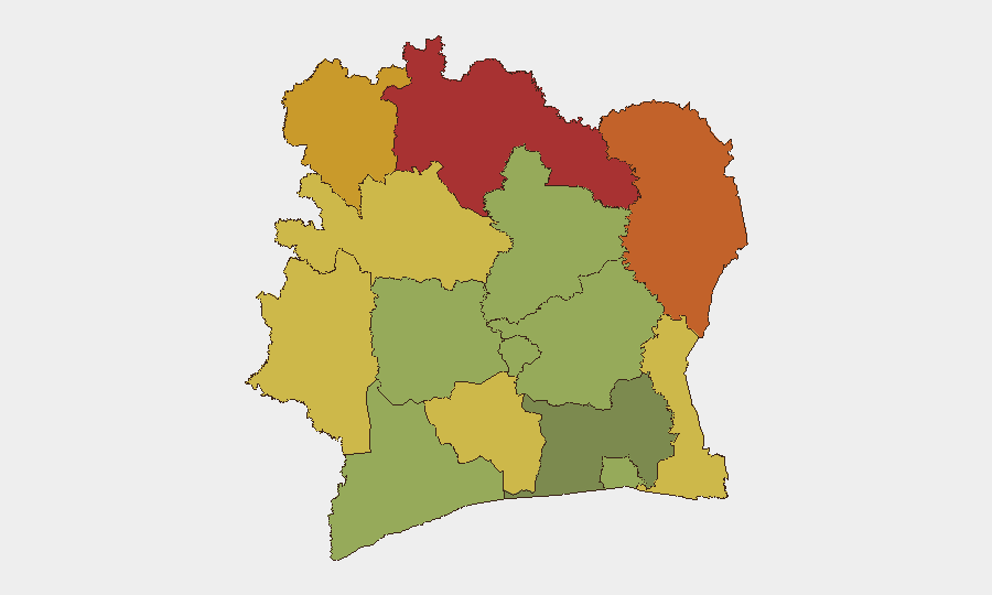
Ivory Coast remains broadly stable at the national level, with a composite threat score of 5 and no tracked discrete security events in the current reporting window. However, the northern border regions—Savanes, Zanzan, and Denguélé districts—continue to carry elevated risk (scores 72–78), reflecting persistent cross-border pressures and limited state capacity in those zones. The capital and primary economic hub, Abidjan, remains at moderate risk (45), consistent with baseline urban crime and trafficking patterns. Overall trajectory suggests no imminent national crisis, but localized vulnerabilities in the north warrant continued monitoring.
Key Developments
No major security, civil unrest, crime, infrastructure, or political incidents have been confirmed in Ivory Coast during the 24–48 hours preceding this brief (16–18 June 2026 UTC). Open-source reporting from regional media, government sources, and social platforms did not yield time-stamped, location-specific incidents meeting operational criteria for inclusion. Routine security operations, minor crime, and administrative activity almost certainly continue, but lack sufficient public documentation for tactical reporting. Teams requiring real-time incident confirmation should task local French-language media monitoring and government security communiqués in parallel with this brief.
Highest-Risk Areas
The northern tier—Savanes (78), Zanzan (75), and Denguélé (72)—drives the country's composite risk profile. These districts sit astride the Mali and Burkina Faso borders, where non-state armed groups, smuggling networks, and militia activity create persistent instability. State administrative and security presence is thin; inter-communal and pastoralist tensions are endemic. Montagnes and Woroba districts (68 and 65) present secondary concern, reflecting similar border dynamics and resource competition. Abidjan's moderate score (45) reflects concentration of urban crime, petty theft, and trafficking rather than organized violence; downtown commercial and port zones carry higher individual risk than suburbs. Central and coastal districts remain substantially lower-risk.
How GeoBit Would Assist
AOI Monitoring & Early Warning should be tasked on Savanes, Zanzan, and Denguélé districts with alerts tuned to cross-border movement, armed-group activity signals, and administrative disruption. OSINT fusion combining French-language X/Twitter, local radio SIGINT, and regional conflict feeds will close gaps in official reporting and provide 4–6 hour lead time on localized flare-ups. Network & Actor Analysis will map smuggling and militia cells operating in the north, supporting route-planning and personnel-risk stratification for any operations in or transiting those zones. Routing & Network Analysis can identify resilient travel alternatives around Savanes and Zanzan that minimize exposure to known checkpoints and volatile corridors.
7-Day Outlook
No significant escalation is anticipated over the next seven days absent a major cross-border incident or political trigger. Routine armed-group activity and inter-communal friction in the north will continue; localized disruptions to commerce, transport, and service delivery are possible but not imminent. Risk posture should remain at current baseline with heightened vigilance in the northern tier and standard urban-crime precautions in Abidjan and secondary cities.
Highest-Risk Areas — Ranked
| # | State / Region | Risk |
|---|---|---|
| 1 | Savanes District | 78 |
| 2 | Zanzan District | 75 |
| 3 | Denguélé District | 72 |
| 4 | Comoé District | 70 |
| 5 | Montagnes District | 68 |
| 6 | Woroba District | 65 |
| 7 | Gôh-Djiboua District | 60 |
| 8 | Sassandra-Marahoué District | 58 |
| 9 | Vallée du Bandama District | 55 |
| 10 | Bas-Sassandra District | 52 |
| 11 | Lacs District | 48 |
| 12 | Abidjan | 45 |
Sources
Previous Daily Briefs
A new Ivory Coast brief is written every day — each with its own risk map and downloadable CSV. Here's the last week; use the calendar to go further back.
📅 Browse every day by calendar →
Highlighted days have a brief. Tap a day for that day's map & analysis, or “csv” for that day's dataset ($5).