Situation Summary
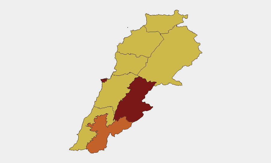
Lebanon faces an intensifying multi-actor security crisis centred on cross-border military operations and internal state fragmentation. Event signals from 6–8 June indicate concurrent conventional military engagements involving Israeli, Iranian, Iraqi, and Lebanese forces, alongside threats directed at terrorist organisations and the Lebanese state itself. Beirut Governorate (98.8 risk) remains the epicentre, but operational intensity is now distributed across southern Lebanon and the Beqaa Valley, signalling a broadening rather than contained conflict.
Key Developments
- Israeli strikes on southern Lebanon and Beirut suburbs (6–8 June). Multiple explosions reported in Beirut's southern suburbs; Israeli military operations targeted approximately 150 Hezbollah-linked sites across southern Lebanon over the 48-hour window. Specific casualty and damage assessments remain preliminary pending independent corroboration.
- Iranian military signalling (7–8 June). Iran rejected unspecified Lebanese/international overtures on 7 June, followed by threat language and reported artillery/tank positioning relative to Lebanese territory on 8 June. Exact deployment locations and intent remain unclear from available reporting.
- Iraqi military involvement (8 June). Conventional military force event recorded between Iraq and Lebanon, suggesting either cross-border operations or military messaging. Context and specifics require urgent clarification.
- Lebanese internal military tensions (8 June). Event signals indicate conventional military engagement between Lebanese ground forces and the Lebanese state, pointing to possible intra-state command fracture or militia–army confrontation. This is distinct from external threats and suggests institutional strain.
- Israeli officer casualties (reported 24-hour window). Social reporting claims 48 Israeli soldiers and officers wounded in southern Lebanon operations, though this remains unconfirmed by independent military sources and should be treated as preliminary.
- Ceasefire/security-zone discussions. One live-update source references Israeli–Lebanese agreement on ceasefire renewal and pilot security zones inside Lebanese territory, but insufficient detail is available to confirm current status or implementation timeline.
Highest-Risk Areas
Beirut Governorate dominates with a 98.8 composite score, reflecting both the capital's administrative and economic centrality and the concentration of military operations in its southern suburbs. Beqaa Governorate (93.9) follows, driven by proximity to the Syrian border, Iranian operational staging, and its use as a supply and command corridor. Together, these two regions account for most active military event signals. Secondary elevation in Nabatieh and South Governorates reflects Israeli operation tempo, while Mount Lebanon and northern regions show moderate baseline risk tied to Hezbollah presence and potential spillover from Beirut-area operations.
How GeoBit Would Assist
Corporate teams should deploy AOI Monitoring & Early Warning on Beirut Governorate, Beqaa, and South Governorate to detect new military concentrations and strike activity in real time. Satellite & Imagery analysis paired with GIS & Spatial Analysis will establish safe-zone corridors and track checkpoint/access-route changes, critical for duty-of-care movement planning. Network & Actor Analysis combined with multi-language OSINT fusion across X, Telegram, and local media will disambiguate state vs. non-state force actions and clarify ceasefire status before it reaches mainstream outlets.
7-Day Outlook
Israeli operations are likely to continue at current or elevated tempo if Iranian or Iraqi force postures are perceived as escalatory. Lebanese state coherence will remain the constraint; any major Lebanese Armed Forces fracture or militia–army clash could trigger secondary displacement and complicate evacuation routes. Ceasefire negotiations are active but fragile, and any single miscalculation or new strike could reset the timeline.
Highest-Risk Areas — Ranked
| # | State / Region | Risk |
|---|---|---|
| 1 | Beirut Governorate | 98.8 |
| 2 | Beqaa Governorate | 93.9 |
| 3 | Nabatieh Governorate | 73.6 |
| 4 | South Governorate | 70.7 |
| 5 | North Governorate | 70.6 |
| 6 | Mount Lebanon Governorate | 69.4 |
| 7 | Baalbek-Hermel Governorate | 69 |
| 8 | Akkar Governorate | 68.8 |
| 9 | Keserwan-Jbeil Governorate | 68.8 |
Sources
Previous Daily Briefs
A new Lebanon brief is written every day — each with its own risk map and downloadable CSV. Here's the last week; use the calendar to go further back.
📅 Browse every day by calendar →
Highlighted days have a brief. Tap a day for that day's map & analysis, or “csv” for that day's dataset ($5).