Situation Summary
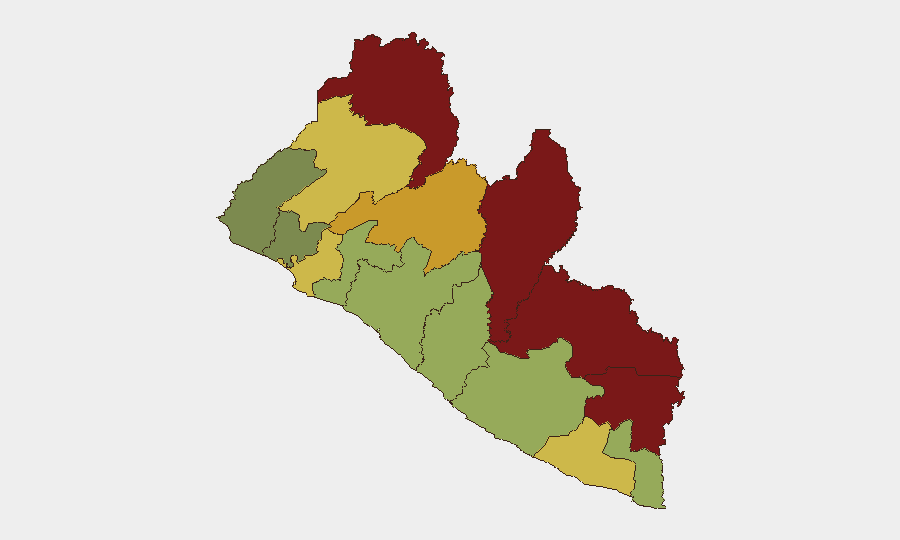
Liberia's overall security environment remains fluid but contains no verified acute incidents in the past 24–48 hours. Open-source monitoring across news feeds, social media, and government statements confirms no new security, conflict, civil-unrest, or crime incidents reported nationwide since 27 July 2026. The underlying risk landscape—shaped by endemic drug trafficking, sporadic protest activity, seasonal flooding, and border-management challenges—remains active but stable; county-level risk remains concentrated in the northeastern border region (Nimba, Lofa, Grand Gedeh).
Key Developments
No verified new security or conflict incidents have been reported in Liberia in the past 24–48 hours (27–29 July 2026). Open-source aggregation, news portals, government channels, and social media feeds confirm no events meeting operational significance thresholds within this window. Earlier events (21–24 July: narcotics enforcement in Margibi County, policy announcements on border management and anti-corruption) fall outside the 24–48-hour window and are retained as background context only. Monitoring will resume escalation protocols should corroborated developments emerge.
Highest-Risk Areas
Nimba County (risk score 92) and Lofa County (risk score 88) continue to drive national threat rankings, reflecting chronic vulnerabilities to cross-border trafficking, irregular migration, and limited state capacity in the Guinean-Sierra Leonean frontier zones. Grand Gedeh (85) and River Gee (83) counties follow, anchoring a consistent pattern: northeastern border counties account for five of the top seven risk positions. Monrovia and Margibi (risk scores 64 and 52) remain secondary focal points for drug-transit activity and police-civilian friction, but rank substantially lower. Risk in southern and central counties (Grand Bassa, Sinoe, Rivercess) reflects lower operational intensity and better infrastructure connectivity.
How GeoBit Would Assist
Security and duty-of-care teams operating in Liberia should employ AOI Monitoring & Early Warning focused on Nimba, Lofa, and Grand Gedeh counties to detect emerging trafficking corridors, protest mobilization, or cross-border movement anomalies in near-real time. OSINT fusion (X/Twitter, Telegram, local radio SIGINT, and multi-language web search) provides continuous situational updates on police enforcement actions, community sentiment shifts, and supply-chain disruptions in higher-risk zones. Routing & Network Analysis supports contingency planning for personnel and asset movement, particularly alternative transportation corridors avoiding Monrovia-to-northern-county routes during periods of heightened enforcement or civil-unrest signaling.
7-Day Outlook
No dramatic escalation is anticipated over the next seven days absent a sharp policy reversal or major trafficking event. Seasonal rainfall will continue to pose localized flooding and infrastructure disruption risks in Monrovia and coastal areas; personnel in those zones should confirm transportation and supply-chain resilience. Monitoring will escalate if substantiated reports emerge of renewed protest mobilization, border-security incidents, or drug-enforcement operations that exceed routine operational thresholds.
Highest-Risk Areas — Ranked
| # | State / Region | Risk |
|---|---|---|
| 1 | Nimba County | 92 |
| 2 | Lofa County | 88 |
| 3 | Grand Gedeh County | 85 |
| 4 | River Gee County | 83 |
| 5 | Bong County | 72 |
| 6 | Gbarpolu County | 68 |
| 7 | Grand Kru County | 65 |
| 8 | Montserrado County | 64 |
| 9 | Rivercess County | 58 |
| 10 | Sinoe County | 55 |
| 11 | Margibi County | 52 |
| 12 | Grand Bassa County | 48 |
Sources
Previous Daily Briefs
A new Liberia brief is written every day — each with its own risk map and downloadable CSV. Here's the last week; use the calendar to go further back.
📅 Browse every day by calendar →
Highlighted days have a brief. Tap a day for that day's map & analysis, or “csv” for that day's dataset ($5).
Atlas — our AI intelligence desk — emails them this snapshot personally. Nothing else, no list.