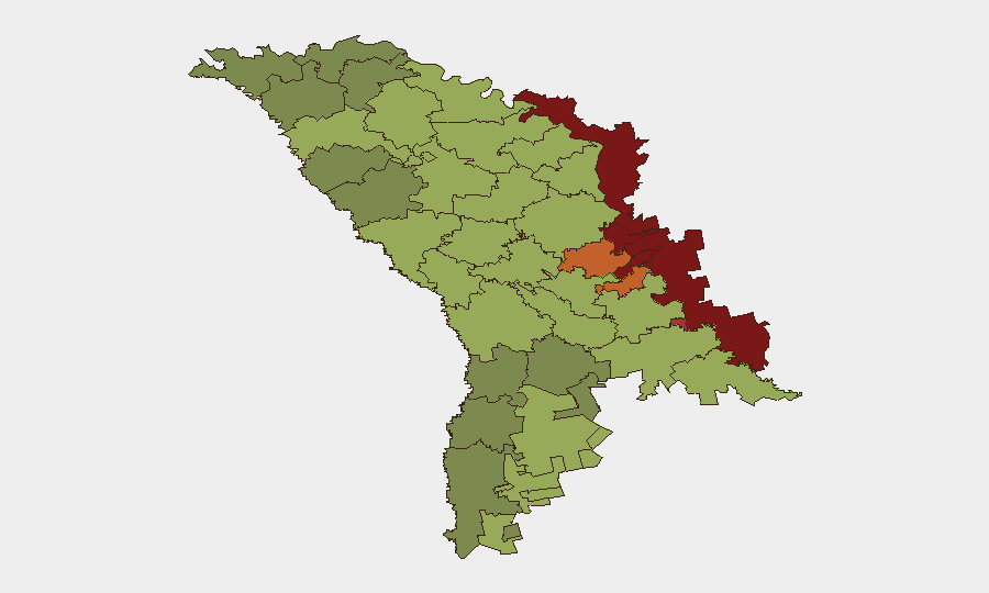
Situation Summary
Moldova's overall security posture remains stable with no acute incidents reported in the last 24–48 hours. The national threat environment is characterized by structural and hybrid risks—diplomatic strain, energy-sector dependencies, and persistent airspace incursions—rather than active violence or civil unrest. Risk concentration remains in the breakaway Transnistrian region and adjacent border areas, where foreign interference, cross-border spillover, and governance fragmentation sustain elevated vulnerability.
Key Developments
- No major incidents confirmed in the last 24–48 hours. Open-source monitoring (news, social media, local reporting) shows no verified protests, attacks, infrastructure outages, or significant civil unrest in Moldova as of 23 June 2026. Recent event signals (threat, rejection, public statements) reflect diplomatic tensions rather than ground-level security events.
- EU–Moldova strategic partnership reaffirmed (Brussels, 22 June). EU leaders confirmed Moldova as a strategic partner and committed to expanded security assistance, with explicit focus on counter-disinformation, cyber-attack resilience, and hybrid-threat mitigation in response to Russia's regional footprint.
- NATO engagement on defense modernization (Chişinău / Brussels, June 2026). Moldovan Foreign Minister Mihai Popșoi held talks with NATO officials on upgrading Moldova's security and defense capabilities to counter foreign interference and regional spillover; NATO publicly acknowledged Moldova's resilience efforts.
- Drone-interception capability in development (national, ongoing). In response to repeated unmanned-aircraft incursions into Moldovan airspace linked to the Ukraine conflict, Moldovan authorities are pursuing interceptor-drone development as a countermeasure to airspace and spillover risks.
- EU renewable-energy policy creating cyber-dependency concerns (national, late May–June). Moldovan customs and VAT policy changes favoring Chinese renewable and battery-storage imports have prompted EU security concerns regarding critical-infrastructure cybersecurity and strategic dependence in the energy sector.
- Flood impact documented (national, recent date unspecified). A significant flood event has been recorded in Moldova; extent, location, and impact on critical infrastructure or displacement remain under assessment via open sources.
Highest-Risk Areas
The Left Bank of the Dniester region (risk 85), Dubăsari (82), and Bender (79) dominate sub-national risk due to contested sovereignty, foreign military presence, weak rule of law, and limited state capacity. Secondary risk zones—Criuleni, Rezina, and Taraclia—reflect cross-border proximity, minority-population concentrations, and vulnerability to disinformation. Even the capital, Chişinău (49), faces hybrid threats and foreign interference. Risk is driven not by acute incidents but by structural fragmentation, external actor influence, and economic dependence.
How GeoBit Would Assist
Security teams should employ AOI Monitoring & Early Warning on the Transnistrian region and key border crossings to detect escalation signals before they materialize into incidents. OSINT fusion and multi-language search (X/Twitter, Telegram, local news) provides real-time awareness of protest activity, infrastructure disruption, and diplomatic shifts. Network & Actor Analysis and regime-stability assessment tools help track foreign interference patterns, disinformation campaigns, and state-capacity degradation shaping Moldova's risk environment.
7-Day Outlook
No acute security deterioration is anticipated over the next week absent external shock. Structural risks—energy dependency, airspace incursions, and Transnistrian tensions—will persist and require sustained monitoring. Diplomatic engagement with NATO and the EU will likely continue to frame Moldova's risk mitigation strategy.
Highest-Risk Areas — Ranked
| # | State / Region | Risk |
|---|---|---|
| 1 | Administrative-Territorial Units of the Left Bank of the Dniester | 85 |
| 2 | Dubăsari | 82 |
| 3 | Bender | 79 |
| 4 | Criuleni | 75 |
| 5 | Rezina | 58 |
| 6 | Taraclia | 55 |
| 7 | Gagauzia | 54 |
| 8 | Căușeni | 53 |
| 9 | Soroca | 52 |
| 10 | Ștefan Vodă | 51 |
| 11 | Orhei | 50 |
| 12 | Chișinău | 49 |
Sources
Previous Daily Briefs
A new Moldova brief is written every day — each with its own risk map and downloadable CSV. Here's the last week; use the calendar to go further back.
📅 Browse every day by calendar →
Highlighted days have a brief. Tap a day for that day's map & analysis, or “csv” for that day's dataset ($5).