Situation Summary
Montenegro remains a low-threat environment globally (composite score 4) with no tracked discrete security events in the current analytical window, but localized criminal activity and environmental hazards have emerged in the past 24–48 hours. Violent crime, including a targeted shooting at a police officer's residence and a homicide in Bar, underscore persistent organized-crime and inter-personal violence risks in coastal and urban centers. Northern mountainous municipalities continue to drive the national risk profile; however, no systemic instability or mass-casualty events are reported.
Key Developments
- Podgorica – shooting at police officer's residence (31 July, ~02:50): Five pistol rounds fired at the home of officer Mervan Ečo; two struck a window, three the exterior wall. Perpetrator remains at large; crime-scene evidence collected and investigation ongoing. Signals targeting of law-enforcement personnel.
- Bar – homicide and arrest (31 July): One fatality in violent incident; two brothers (Dragoslav and Duško Ivanović) arrested. Police report situation contained; no broader security escalation indicated.
- Podgorica – child-abuse arrest (31 July): Local resident arrested on suspicion of indecent acts against a 13-year-old family member. Localized criminal matter; investigation ongoing.
- Herceg Novi – Mount Orjen wildfire (31 July, partially contained): Active wildfire brought under control; firefighters halted spread toward Boriči and Snežnika. Emergency services remain on scene; potential air-quality and road-access impacts in the region.
- Budva – drowning at Mogren II beach (31 July): 30-year-old Serbian national drowned; no indication of foul play. Underscores baseline coastal-safety hazards during peak tourism season.
- Tivat Airport – temporary closure (31 July): Air traffic suspended due to bird-strike risk on runway; operational disruption cleared after wildlife dispersal. Short-term but relevant for airport-dependent travelers.
- Đurđevića Tara bridge – full closure announced (10 August–26 October 2026): Major tourist and logistics route between Žabljak and Plužine to close for reconstruction. Affects route planning and emergency access in Tara canyon zone.
- Airports of Montenegro – concession process suspended (31 July): Government halted management concession over advance-payment disputes and deal viability concerns. No immediate operational impact reported; medium-term infrastructure governance issue.
Highest-Risk Areas
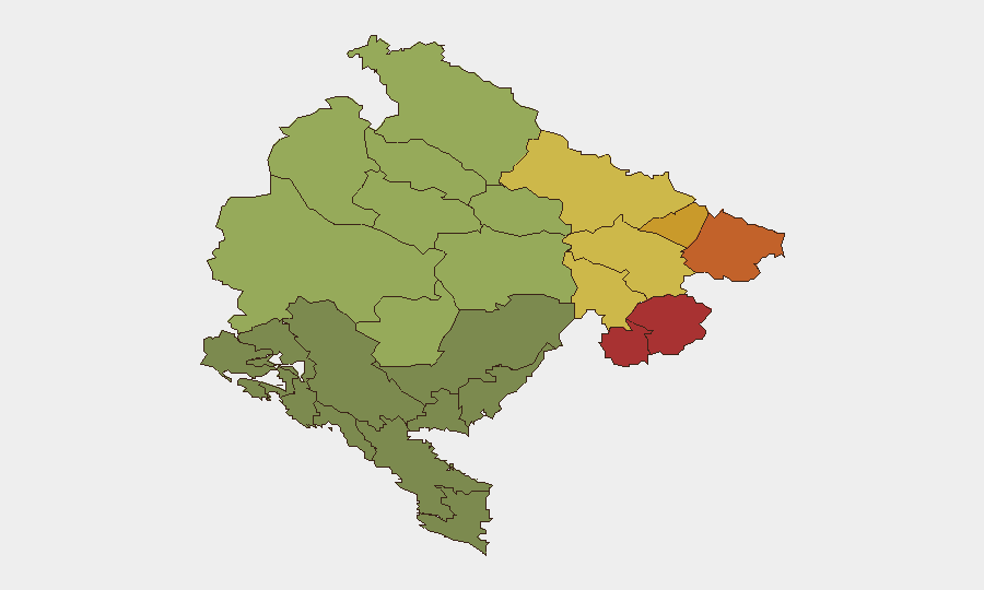
The northern municipalities of Plav, Gusinje, Rožaje, and Petnjica carry the highest composite risk scores (78–72), primarily reflecting organized-crime, trafficking, and cross-border smuggling networks linked to the Kosovo border region. These areas, combined with Andrijevica and Bijelo Polje (risk 68 and 65), form a high-risk corridor; tourism and commercial activity remain limited. Recent violent crime in Podgorica and Bar—both urban centers outside the top 12 ranked municipalities—indicates that organized-crime and interpersonal violence also manifest in coastal and capital-region nodes, albeit at lower frequency. Risk concentration in the north reflects both geography (proximity to Balkans trafficking routes) and weaker governance capacity.
How GeoBit Would Assist
Intel Sweep and multi-language OSINT would provide real-time monitoring of Montenegrin news, social media, and police updates to flag emerging threats in priority locations. AOI Monitoring & Early Warning on Podgorica, Bar, Herceg Novi, and the northern risk corridor would surface incidents and environmental hazards before they escalate. Routing & Network Analysis would help security teams identify safe alternative routes around the Tara bridge closure and assess post-incident safety in affected municipalities.
7-Day Outlook
Organized-crime and petty violent-crime activity is expected to persist at baseline levels; the northern border municipalities remain surveillance priorities. The Tara bridge closure (effective 10 August) will redirect traffic and may create logistical and emergency-response strain in Žabljak and Plužine zones. No escalation in state-level instability or mass-casualty risk is anticipated in the near term.
Highest-Risk Areas — Ranked
| # | State / Region | Risk |
|---|---|---|
| 1 | Plav Municipality | 78 |
| 2 | Gusinje Municipality | 76 |
| 3 | Rožaje Municipality | 74 |
| 4 | Petnjica Municipality | 72 |
| 5 | Andrijevica Municipality | 68 |
| 6 | Bijelo Polje Municipality | 65 |
| 7 | Berane Municipality | 62 |
| 8 | Plužine Municipality | 58 |
| 9 | Pljevlja Municipality | 55 |
| 10 | Šavnik Municipality | 52 |
| 11 | Žabljak Municipality | 50 |
| 12 | Kolašin Municipality | 48 |
Sources
Previous Daily Briefs
A new Montenegro brief is written every day — each with its own risk map and downloadable CSV. Here's the last week; use the calendar to go further back.
📅 Browse every day by calendar →
Highlighted days have a brief. Tap a day for that day's map & analysis, or “csv” for that day's dataset ($5).
Atlas — our AI intelligence desk — emails them this snapshot personally. Nothing else, no list.