Situation Summary
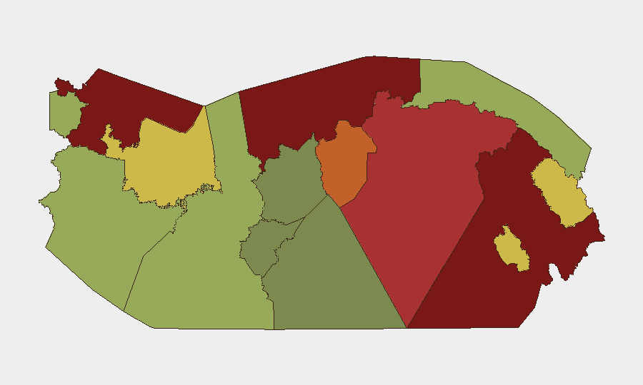
Panama remains a moderate-to-low global threat environment (rank #56 globally, composite score 35), but sub-national risk is highly concentrated in border and transit regions—particularly Darién, Colón, and Bocas del Toro—where gang activity, narcotics trafficking, and migrant-route violence drive vulnerability. The past week saw no major discrete security incidents, but ongoing concerns in Panama Oeste and Veracruz districts, infrastructure disruptions, and persistent Canal water-stress logistics have maintained operational friction. The security trajectory remains stable but fragmented by geography, with inland/port areas showing sustained pressure while central Panama City remains relatively controlled.
Key Developments
- Panama City (Sept. 21): A 25-year-old Metro Line 3 subcontractor died following electrocution at the construction site; workplace safety oversight remains under review.
- Panama maritime area (Sept. 21): The Panama Maritime Authority initiated an investigation into an incident involving the supply vessel *Ventura Too* during the night of September 21.
- La Chorrera, Panama Oeste (Sept. 22): The National Police conducted preventive patrols across multiple sectors in response to localized crime concerns.
- Panama Oeste Province (Sept. 26): During a Provincial Council meeting, residents and officials formally requested increased police presence, vehicles, and equipment, citing ongoing robberies, homicides, and drug activity.
- Panama City (Sept. 26–28): Announced operational simulations for Fourth Bridge over the Panama Canal—including overnight lane closures on Amador, Arnulfo Arias Madrid, and Ascanio Arosemena avenues—were cancelled; no disruptions occurred.
- Veracruz, Panama District (Sept. 27): The local mayor formally requested a police assessment of curfew feasibility in response to district-level security concerns.
- Villa Marina and Santiago (Sept. 27): Residents staged a protest and temporarily blocked the Pan-American Highway to draw attention to deteriorating road conditions; disruption was brief.
- Panama Canal / Gatún Lake (Sept. 25): El Niño-related hydrology stress continued; the Canal Authority maintained reduced operating parameters (32 daily transits, 48-foot draft maximum). Gatún Lake registered 84.53 feet on September 22.
- Nationwide (Sept. 27): Civil-protection authorities issued a preventive weather alert for ongoing rain and thunderstorms, presenting short-term infrastructure and travel risk.
Highest-Risk Areas
Darién (95), Colón (88), and Bocas del Toro (82) represent the critical threat tier, driven by gang territorial control, narcotics production and transit, and limited state presence. Panamá Province and Oeste (78 and 75 respectively) carry elevated risk rooted in organized-crime activity targeting residents and commerce; the week's security appeals from Oeste reflect active citizen concern. Indigenous territories (Ngäbe-Buglé, Emberá-Wounaan, Guna Yala) and central provinces carry moderate-to-lower risk but remain subject to trafficking activity and sporadic gang encroachment. Central Panama City remains the most stable operational hub despite these regional pressures.
How GeoBit Would Assist
Security teams managing Panama operations would deploy AOI Monitoring & Early Warning on high-risk provinces (Darién, Colón, Panamá Oeste) to detect gang activity, route closures, or incident escalation in real time. Intelligence & OSINT capabilities—including X/Telegram surveillance, sentiment analysis, and event-feed fusion—provide early signals of local unrest, police deployments, or supply-chain disruptions (e.g., Canal transit changes). Routing & Network Analysis enables rapid alternative-route planning for personnel and cargo in response to closures, protests, or security incidents.
7-Day Outlook
Near-term risk is expected to remain stable and sub-national; no national-level political or security shock is imminent. Darién and Colón will continue to require heightened vigilance for trafficking-related violence and migrant-route instability. Hydrology constraints on the Canal are likely to persist through the remainder of the El Niño cycle, requiring ongoing logistics flexibility for shipping schedules.
Highest-Risk Areas — Ranked
| # | State / Region | Risk |
|---|---|---|
| 1 | Darién | 95 |
| 2 | Colón | 88 |
| 3 | Bocas del Toro | 82 |
| 4 | Panamá Province | 78 |
| 5 | Panamá Oeste | 75 |
| 6 | Ngäbe-Buglé | 68 |
| 7 | Emberá-Wounaan | 62 |
| 8 | Veraguas | 58 |
| 9 | Chiriquí | 48 |
| 10 | Naso Tjër Di | 45 |
| 11 | Guna Yala | 42 |
| 12 | Coclé | 35 |
Sources
Previous Weekly Briefs
A new Panama brief is written every Monday, covering the week — each with its own risk map and downloadable CSV. Use the calendar to go further back.
- September 21, 2026
- September 14, 2026
- September 7, 2026
- September 1, 2026
- August 31, 2026
- August 30, 2026
- August 29, 2026
📅 Browse past briefs by calendar →
Highlighted days have a brief. Tap a day for that day's map & analysis, or “csv” for that day's dataset ($5).
Atlas — our AI intelligence desk — emails them this snapshot personally. Nothing else, no list.