Situation Summary
Samoa remains a low-threat environment with a composite threat score of 44 and no verified incidents of conflict, civil unrest, major crime, or infrastructure failure in the past 24–48 hours. The security picture is stable across all major islands, with government and public services operating normally. Near-term risk is concentrated in Tuamasaga (Upolu's capital district), which accounts for the majority of the country's composite threat score; however, current open-source reporting indicates no acute triggers or escalation drivers.
Key Developments
- Nationwide, 17 June – Samoa's National Emergency Operation Centre confirmed fuel reserves at approximately 42 days of diesel, 48 days of petrol, and 82 days of jet fuel. An Amber Level advisory remains in place as a precautionary measure; no fuel shortage, rationing, or service disruption has occurred, and no civil unrest has been reported.
- Faleolo International Airport, Upolu, mid-June – A temporary low-voltage power disruption affected the airport terminal; power has been fully restored and all airport operations have returned to normal. No safety, security, or flight scheduling impact reported.
- National level, 17 June – The Government Press Secretariat noted that two Samoan nationals are in custody in Vietnam in connection with an overseas murder investigation. No domestic reprisals, protests, or security incidents have been linked to this external legal matter within Samoa.
- Apia & main islands, 17–18 June – Government and public activities in Upolu and Savai'i continue without disorder or public-order incidents. No new crime spikes, traffic disruptions, or infrastructure failures are reported.
Highest-Risk Areas
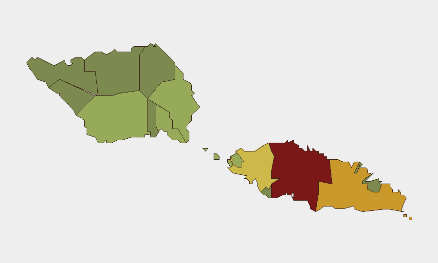
Tuamasaga district (risk score 85) dominates Samoa's composite threat profile and merits priority monitoring; it encompasses Apia, the capital, where government, commercial, and port infrastructure concentrates. Ātua (71) and Aʻana (62) follow as secondary concern areas. These rankings likely reflect urbanization, population density, and baseline crime rates rather than acute conflict or instability; current reporting confirms no active incidents in these districts. The lower-risk districts (Vaisigano, Vaʻa-o-Fonoti) show substantially reduced exposure and do not contribute materially to the national threat score.
How GeoBit Would Assist
Corporate security and duty-of-care teams should use GeoBit's AOI Monitoring & Early Warning capability to maintain persistent watch on Tuamasaga (especially port, airport, and government facilities) with real-time alerting on civil unrest, labor action, or crime escalation. OSINT fusion and multi-language social-media analysis (X, Telegram, local news) provide rapid detection of emerging political tensions or public sentiment shifts that may precede formal incidents. For supply-chain and personnel routing, Routing & Network Analysis combined with Economic & Trade monitoring supports contingency planning around fuel and shipping disruptions.
7-Day Outlook
No material escalation is anticipated in the seven-day horizon absent external shocks (e.g., regional geopolitical events, major natural disaster, or unforeseen labor action). The precautionary fuel advisory is expected to remain in place during normal tanker scheduling; no acute supply crisis is forecast. Monitoring should remain focused on Tuamasaga and sustained OSINT watch for sentiment shifts or political friction.
Highest-Risk Areas — Ranked
| # | State / Region | Risk |
|---|---|---|
| 1 | Tuamasaga | 85 |
| 2 | Ātua | 71 |
| 3 | Aʻana | 62 |
| 4 | Aiga-i-le-Tai | 55 |
| 5 | Faʻasaleleaga | 48 |
| 6 | Palauli | 42 |
| 7 | Satupaʻitea | 38 |
| 8 | Gagaʻemauga | 35 |
| 9 | Gagaʻifomauga | 32 |
| 10 | Vaisigano | 28 |
| 11 | Vaʻa-o-Fonoti | 23 |
Sources
Previous Daily Briefs
A new Samoa brief is written every day — each with its own risk map and downloadable CSV. Here's the last week; use the calendar to go further back.
📅 Browse every day by calendar →
Highlighted days have a brief. Tap a day for that day's map & analysis, or “csv” for that day's dataset ($5).