Situation Summary
Saudi Arabia faces elevated aerial and drone threat activity within a broader regional escalation context, with air-defence systems intercepting multiple hostile unmanned systems over the past 48 hours and missile-alert sirens activated near Prince Sultan Air Base on 11 June. The kingdom's Foreign Ministry has issued solidarity statements with Bahrain and Kuwait following Iranian-aligned attacks in the Gulf, signalling Saudi Arabia's direct stake in an expanding conflict dynamic. Riyadh Region remains the primary domestic risk concentration (77.7 composite score), driven by military and government infrastructure clustering. Overall threat posture remains contained but trajectory is upward.
Key Developments
- Al Kharj, Riyadh Region – 11 June 0600h UTC (approx.): Civil Defence air-alert sirens activated at Prince Sultan Air Base and surrounding Al Kharj governorate; Saudi Ministry of Defense later announced threat cleared with no damage or casualties, consistent with successful interception or false alarm rather than impact event.
- Kingdom-wide airspace – past 48 hours through 11 June: Ministry of Defense confirmed interception of multiple hostile drones over Saudi territory; no damage or casualty reports issued, indicating active air-defence engagement against sustained unmanned incursions.
- Saudi Foreign Ministry statement – 10–11 June: Kingdom publicly condemned Iranian missile and drone attacks on Bahrain and Kuwait, declared regional escalation a threat to Saudi security and stability, and announced solidarity with both neighbours—explicit signal of Saudi Arabia's perceived vulnerability to spillover.
- Budget Saudi (cyber incident) – disclosed 10–11 June: Car-rental firm disclosed unauthorized access to customer data affecting limited user base; operational impact unclear but containment procedures reported underway.
- UN Security Council remarks – 10–11 June: Secretary-General flagged escalating Gulf-region strike activity and air-defence operations as risk vector for broader conflict, implicitly referencing Saudi Arabia's operational environment.
- Arab Group (UN) maritime/infrastructure warning – 10–11 June: Coalition of Arab states explicitly warned of spillover risk to civilian infrastructure, maritime routes, and Strait of Hormuz freedom of navigation—direct concern for Saudi commercial and energy security.
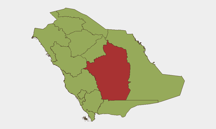
Highest-Risk Areas
Riyadh Region dominates the sub-national risk matrix (77.7 vs. 47.7 baseline for most other provinces), reflecting concentration of military infrastructure, government ministries, and critical air-defence assets—including Prince Sultan Air Base. The 30-point spread between Riyadh and secondary zones (Makkah, Eastern Province, Northern Borders) indicates asymmetric vulnerability centred on the capital and its outlying defence perimeter. Eastern Province (48.1) and Northern Borders Province (47.7) carry secondary risk from maritime proximity and cross-border militia activity, but current escalation cycle is capital-centric.
How GeoBit Would Assist
Security and risk teams should deploy AOI Monitoring & Early Warning on Riyadh Region military installations and civil-defence infrastructure to detect siren activation, drone signatures, and air-traffic anomalies in real time. Conflict & Military tracking (force structure, air-defence posture, weapons-capability trends) combined with Network & Actor Analysis of Iranian-aligned drone operators and multi-language OSINT (Arabic social media, Telegram channels, regional news feeds) would provide 12–48-hour early warning of incoming threats. Maritime & Aviation tracking should monitor regional launch patterns from Iran, Yemen, and Iraq to establish predictive windows for Saudi airspace incursions.
7-Day Outlook
Aerial threat activity is likely to persist or intensify over the next week as regional actors test Saudi air defences in the context of broader Gulf escalation. Riyadh Region will remain the highest-risk zone; secondary provinces may see spillover incidents if attacks broaden geographically. Corporate duty-of-care teams should assume elevated alert posture for personnel near military sites and critical infrastructure and maintain real-time communication with local civil defence and employer security operations.
Highest-Risk Areas — Ranked
| # | State / Region | Risk |
|---|---|---|
| 1 | Riyadh Region | 77.7 |
| 2 | Makkah Region | 48.6 |
| 3 | Eastern Province | 48.1 |
| 4 | Northern Borders Province | 47.7 |
| 5 | Al-Bahah Province | 47.7 |
| 6 | 'Asir Province | 47.7 |
| 7 | Jazan Province | 47.7 |
| 8 | Najran Region | 47.7 |
| 9 | Tabuk Province | 47.7 |
| 10 | Al Jawf Region | 47.7 |
| 11 | Ḥa'il Province | 47.7 |
| 12 | Medina Province | 47.7 |
Sources
Previous Daily Briefs
A new Saudi Arabia brief is written every day — each with its own risk map and downloadable CSV. Here's the last week; use the calendar to go further back.
📅 Browse every day by calendar →
Highlighted days have a brief. Tap a day for that day's map & analysis, or “csv” for that day's dataset ($5).