Situation Summary
Senegal remains a relatively stable West African nation (global rank #85, composite threat score 8), with no significant security incidents confirmed in the last 24–48 hours inside the country. The security environment is dominated by localized threat concentration in the northeastern Tambacounda Region, where militant and criminal activity drive the majority of national risk. Political developments—including ongoing tensions between President Bassirou Diomaye Faye and former Prime Minister Ousmane Sonko—warrant continued monitoring for potential destabilization, though no acute security incidents have been reported as of 14 June 2026.
Key Developments
No verifiable security, conflict, civil unrest, or crime incidents in Senegal have been independently confirmed in the last 24–48 hours through available open-source and social-media intelligence. Recent web coverage has focused on Senegal's national football team undergoing heightened security screening at U.S. airports ahead of the 2026 World Cup—a procedural matter unrelated to conditions inside Senegal. Ongoing political uncertainty between President Faye and Sonko (including Sonko's dismissal from the Prime Minister role and subsequent appointment as parliamentary speaker) remains a background risk factor but has not escalated into demonstrable security incidents as of this reporting window.
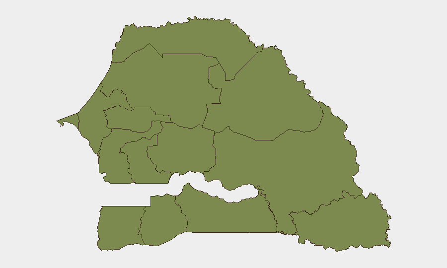
Highest-Risk Areas
Tambacounda Region in northeastern Senegal dominates national threat concentration, with a composite risk score of 31.4—nearly 2.5× higher than the second-tier regions (Louga and Fatick, each 12.7). This regional concentration reflects persistent militant activity, cross-border infiltration from Mali, and limited state capacity in remote border areas. Louga and Fatick regions pose secondary risk; all remaining regions, including the capital Dakar, register minimal scores (1.4–5.2). Corporate assets and personnel in Tambacounda should be treated as higher-risk; Dakar and major urban centers remain substantially lower-threat environments.
How GeoBit Would Assist
Security teams with operations in Senegal should employ Intel Sweep and global event feeds to detect emerging incidents in Tambacounda and border zones in near-real time, paired with multi-language OSINT (X/Twitter, Telegram, local radio SIGINT) to capture militia communications, political rhetoric, and public sentiment early. AOI Monitoring & Early Warning on Tambacounda's key transport corridors and administrative centers, combined with GIS & Spatial Analysis, enables predictive positioning of personnel and asset-protection resources. Regime-stability search and sentiment analysis on the Faye–Sonko political rift will flag if political fragmentation accelerates toward civil unrest, allowing duty-of-care teams to pre-position contingency protocols.
7-Day Outlook
No acute escalation is anticipated in the immediate 7-day window. However, the underlying political rift between Faye and Sonko merits close watch; parliamentary sessions and political statements over the next week may signal whether tensions are stabilizing or deepening. Tambacounda Region threat levels are expected to remain consistent with historical patterns; any cross-border spillover from Mali's ongoing instability should be monitored as the principal near-term wildcard for national security.
Highest-Risk Areas — Ranked
| # | State / Region | Risk |
|---|---|---|
| 1 | Tambacounda Region | 31.4 |
| 2 | Louga Region | 12.7 |
| 3 | Fatick Region | 12.7 |
| 4 | Diourbel Region | 5.2 |
| 5 | Dakar Region | 1.4 |
| 6 | Thiès Region | 1.4 |
| 7 | Kaolack Region | 1.4 |
| 8 | Saint-Louis Region | 1.4 |
| 9 | Kaffrine Region | 1.4 |
| 10 | Ziguinchor Region | 1.4 |
| 11 | Sédhiou Region | 1.4 |
| 12 | Kolda Region | 1.4 |
Sources
Previous Daily Briefs
A new Senegal brief is written every day — each with its own risk map and downloadable CSV. Here's the last week; use the calendar to go further back.
📅 Browse every day by calendar →
Highlighted days have a brief. Tap a day for that day's map & analysis, or “csv” for that day's dataset ($5).