Situation Summary
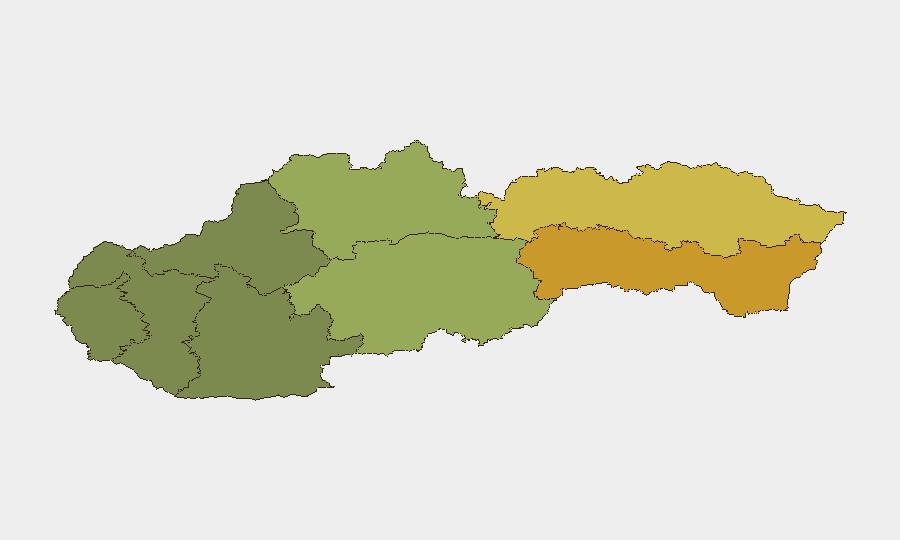
Slovakia remains in a low acute-threat posture as of 26 July 2026, with no confirmed major security incidents, civil unrest, or infrastructure failures reported in the last 24–48 hours in accessible open-source reporting. The composite national threat score of 12 places Slovakia in a stable band; however, event signals involving small-arms combat linked to Budapest–Slovakia tensions and concurrent public statements from France and internal Slovak actors merit close monitoring for escalation. Regional variance is pronounced, with eastern regions (Košice, Prešov) significantly elevated above western and central areas.
Key Developments
- Budapest–Slovakia Border Area, 26 July 2026 (multiple events): Small-arms combat incidents reported involving Budapest and Slovakia actors on both 26 July, with bidirectional engagement signals (Budapest vs. Slovakia; Slovakia vs. Budapest). No casualty count or exact location specificity available from open sources; escalation risk requires clarification.
- France–Slovakia Diplomatic Statements, 25–26 July 2026: Public statements issued by French actors toward Slovakia and Bratislava (25 July) and from France toward Slovak Republic (26 July). Context of these statements—whether economic, political, or security-related—remains unclear from available summaries; diplomatic tension indicator flagged.
- Domestic Political Statements, 25 July 2026: Multiple public statements recorded between Slovak actors and institutions, including Reformed Church engagement. No associated incidents or unrest reported; routine political discourse context.
- United Kingdom Small-Arms Signal, 26 July 2026: Signal recorded on 26 July; geographic specificity and context not available from summary data. Requires clarification on whether incident is *within Slovakia* or related to Slovak actors elsewhere.
- Open-Source Verification Finding: Comprehensive cross-check of national news wires, regional outlets, police feeds, and Slovak-language social media for the 24–48 hour window did not independently confirm major security, conflict, or unrest incidents. Event signals in GeoBit feed may reflect international coverage, social-media discussion, or regional reporting not yet reflected in primary national sources.
Highest-Risk Areas
Eastern Slovakia—Košice Region (risk 72) and Prešov Region (risk 68)—drives the majority of the national composite risk, likely reflecting proximity to Hungary (Budapest tensions noted in current signals), historical minority populations, and cross-border criminal networks. Banská Bystrica Region (risk 55) in central Slovakia also exceeds the national median. Western and southwestern regions (Bratislava, Trenčín, Trnava) remain substantially lower-risk. The clustering of elevated risk in the east aligns with recent combat-related event signals tied to Budapest–Slovakia interaction.
How GeoBit Would Assist
AOI Monitoring & Early Warning on the Budapest–Slovakia border and eastern regions (Košice, Prešov) would provide persistent, real-time alerting on cross-border incidents, crowd movement, and escalation signals. Network & Actor Analysis would map French, Hungarian, and Slovak institutional and non-state actors issuing public statements, clarifying diplomatic intent and internal political drivers. Intel Sweep, OSINT fusion, and multi-language search would close gaps between GeoBit event feeds and Slovak open-source reporting, validating or contextualizing current combat signals within 12 hours.
7-Day Outlook
Near-term trajectory depends on clarification of the Budapest border incidents and Franco-Slovak diplomatic messaging. If border tensions de-escalate and statements reflect routine bilateral business, risk trajectory stabilizes downward. If either signal indicates sustained military posturing or economic coercion, regional destabilization in the east could accelerate. Continued daily monitoring of Košice and Prešov regions is warranted through 2 August 2026.
Highest-Risk Areas — Ranked
| # | State / Region | Risk |
|---|---|---|
| 1 | Region of Košice | 72 |
| 2 | Region of Prešov | 68 |
| 3 | Region of Banská Bystrica | 55 |
| 4 | Region of Žilina | 42 |
| 5 | Region of Nitra | 35 |
| 6 | Region of Bratislava | 28 |
| 7 | Region of Trenčín | 22 |
| 8 | Region of Trnava | 18 |
Sources
Previous Daily Briefs
A new Slovakia brief is written every day — each with its own risk map and downloadable CSV. Here's the last week; use the calendar to go further back.
📅 Browse every day by calendar →
Highlighted days have a brief. Tap a day for that day's map & analysis, or “csv” for that day's dataset ($5).
Atlas — our AI intelligence desk — emails them this snapshot personally. Nothing else, no list.