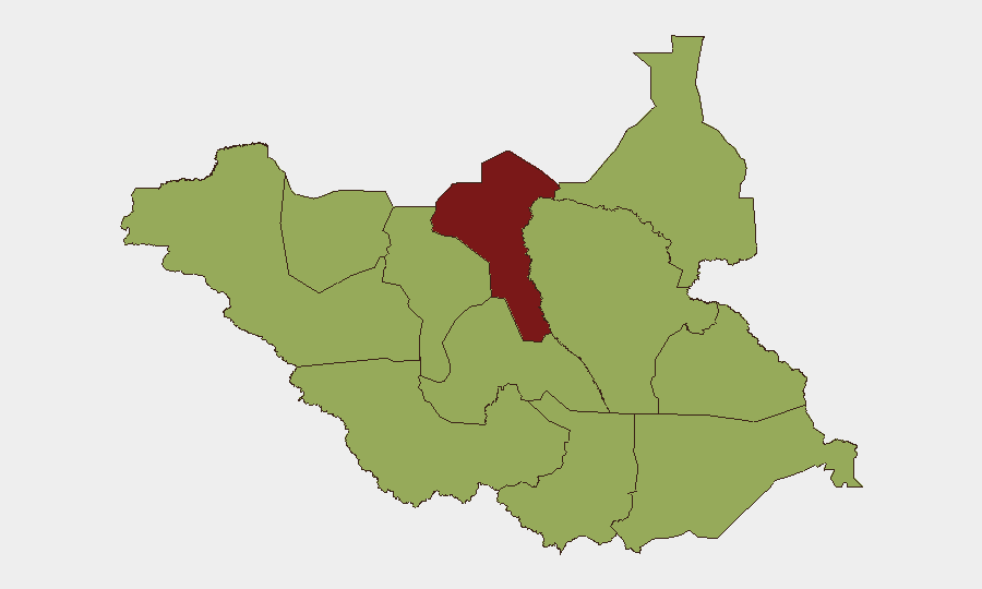
Situation Summary
South Sudan remains in a state of protracted armed conflict and communal violence, with the security environment continuing to deteriorate in oil-producing northern states and pastoralist regions. The past week saw a significant escalation in Rumbek, Lakes State, where intercommunal youth clashes resulted in at least 71 deaths and forced mass civilian displacement. Concurrent reports from the South Sudan Council of Churches indicate armed mobilization and violence spreading across Upper Nile, Jonglei, and Unity states, signaling a widening geographic footprint of organized and communal armed activity. The trajectory remains volatile with limited near-term de-escalation indicators.
Key Developments
- Rumbek, Lakes State — October 9 (morning): Armed clashes between Nyang and Pakam community youth began approximately 4 a.m. in Nyangkot before spreading into Rumbek town proper. Government preliminary casualty count: 71 deaths including four soldiers; joint security forces deployed and reported regaining control by October 10, with four civilians arrested.
- Rumbek, Lakes State — October 10–11: Security forces maintained deployment; authorities urged residents against retaliatory action. Death toll remained classified as preliminary pending investigation.
- Nasir and Ulang counties, Upper Nile State — October 6: South Sudan Council of Churches reported renewed violence and armed-youth mobilization with reported deaths, displacement, and documented restrictions on humanitarian access.
- Nyirol, Uror, Ayod, and Akobo counties, Jonglei State — October 6: Church leaders identified insecurity and armed-youth mobilization affecting multiple counties; reporting lacked specific incident dates or casualty figures for the reporting week.
- Greater Pibor Administrative Area — October 6: Armed-youth mobilization documented alongside broader insecurity affecting the region; incident-specific details not independently confirmed for the week.
- Bentiu and Ruweng Administrative Area, Unity State — October 6: Council of Churches warned of continuing insecurity and displacement risk to vulnerable communities; no separately dated attack identified during October 6–12.
- Road networks, Equatoria region — October 6: Attacks and insecurity reported along routes connecting Juba with Mundri, Torit, and Yei, disrupting civilian and humanitarian movement; specific incidents not dated.
Highest-Risk Areas
Unity and Jonglei states dominate the risk landscape (scores 95 and 93 respectively), driven by persistent armed-group presence, oil-sector competition, and active communal resource conflicts. Upper Nile and Greater Pibor Administrative Area follow closely (88 and 87), characterized by sustained intercommunal violence over pastoral resources and grazing rights, compounded by weak state capacity and humanitarian access constraints. Northern Bahr el Ghazal (82) and Lakes (78) round out the critical tier, with Lakes' recent Rumbek escalation exemplifying how localized youth mobilization can rapidly produce mass-casualty incidents. By contrast, Western Equatoria and Central Equatoria (38 and 35) present materially lower but non-negligible risk, particularly along key transport corridors.
How GeoBit Would Assist
Security teams should employ Area-of-Interest (AOI) Monitoring & Early Warning on high-risk counties (Nasir, Uror, Bentiu, Rumbek) to detect mobilization and violence triggers before large-scale escalation. Conflict & Military mapping and Network & Actor Analysis enable tracking of armed-youth organization, command structures, and seasonal resource-conflict patterns. Routing & Network Analysis supports alternative journey planning for personnel and supply movement, particularly along compromised Equatoria corridors and northern pastoral zones.
7-Day Outlook
Rumbek security-force presence and detention of suspects may temporarily suppress direct violence, but underlying communal grievances remain unresolved and intercommunal youth mobilization continues across northern and pastoral regions. Upper Nile and Jonglei counties face elevated risk of renewed clashes within 7–14 days absent rapid humanitarian and mediation engagement. Humanitarian access constraints will likely persist, limiting casualty reporting accuracy and early-warning visibility.
Highest-Risk Areas — Ranked
| # | State / Region | Risk |
|---|---|---|
| 1 | Unity | 95 |
| 2 | Jonglei | 93 |
| 3 | Upper Nile | 88 |
| 4 | Greater Pibor Administrative Area | 87 |
| 5 | Northern Bahr el Ghazal | 82 |
| 6 | Lakes | 78 |
| 7 | Warrap | 72 |
| 8 | Ruweng Administrative Area | 68 |
| 9 | Eastern Equatoria | 52 |
| 10 | Western Equatoria | 38 |
| 11 | Central Equatoria | 35 |
| 12 | Western Bahr el Ghazal State | 28 |
Sources
Previous Weekly Briefs
A new South Sudan brief is written every Monday, covering the week — each with its own risk map and downloadable CSV. Use the calendar to go further back.
- October 5, 2026
- September 28, 2026
- September 21, 2026
- September 14, 2026
- September 7, 2026
- September 1, 2026
- August 30, 2026
📅 Browse past briefs by calendar →
Highlighted days have a brief. Tap a day for that day's map & analysis, or “csv” for that day's dataset ($5).
Atlas — our AI intelligence desk — emails them this snapshot personally. Nothing else, no list.