Situation Summary
Togo remains stable in terms of confirmed security incidents, with no attack, armed clash, or major civil unrest recorded in the past 24–48 hours. However, a political controversy regarding alleged foreign military deployments in the northern Savanes Region has generated significant discourse among opposition parties and civil-society organizations since July 21–22, centering on claims of Russian "Africa Corps" and Turkish SADAT personnel presence. This political tension has not yet translated into verified operational incidents, but it signals potential friction points in the north and underscores governance transparency concerns.
Key Developments
- Lomé, July 21, 2026 – Opposition coalition and civil-society groups publicly issued statements alleging the presence of approximately 350 Russian Africa Corps operatives and Turkish-linked contractors in Savanes Region, citing sovereignty and human-rights concerns. No accompanying incident or clash was reported.
- Savanes Region (northern Togo), July 21–22, 2026 – Opposition and civic organizations demanded government clarification on foreign military and paramilitary deployments; claims remain unverified and no new security operations or confrontations were confirmed in available open-source reporting.
- National media environment, July 22, 2026 – Coverage of the foreign-troop allegations amplified across news and social platforms; discourse focused on transparency and risk of potential abuses, but produced no reports of new attacks or armed activity.
- Countrywide incident sweep, July 23–24, 2026 – Open-source monitoring and X/Twitter surveillance identified no independently verified attack, armed clash, major arrest, infrastructure damage, or acute security event in the past 24–48 hours across Togo.
Highest-Risk Areas
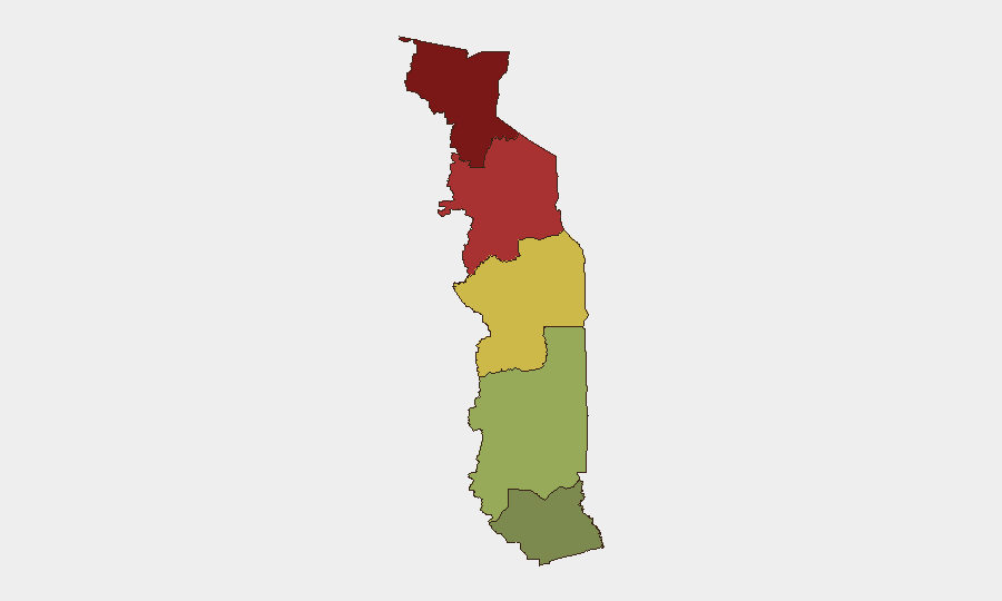
Savanes Region (risk score 92) and Kara Region (risk score 78) dominate the sub-national risk profile, driven by proximity to Mali and Burkina Faso, historical trafficking and extremist-group presence, limited state capacity, and—as of late July—the political controversy over foreign military deployments. Centrale Region (65) remains elevated due to similar border and capacity constraints. Maritime (28) and Plateaux (45) regions carry substantially lower risk profiles. Corporate and expatriate personnel in Savanes and Kara should treat the current political discourse as a potential early-warning signal; Lomé and coastal areas remain comparatively lower-risk.
How GeoBit Would Assist
Teams with people or assets in Togo should employ AOI Monitoring & Early Warning on Savanes and Kara regions to detect escalation of the current political controversy into operational incidents. OSINT fusion & corroboration (X/Twitter, opposition media, and local civic networks) combined with Intel Sweep can track whether foreign military claims materialize into visible deployments or incidents. Routing & Network Analysis enables security teams to identify alternative travel corridors and safe zones in northern regions, mitigating exposure to emerging friction points.
7-Day Outlook
No new major incidents are anticipated in the immediate term (24–72 hours); however, the foreign-troop controversy and calls for government transparency may continue to generate political statements and media activity. Monitor Savanes for any signs of operational activity, civilian mobilization, or government response that could indicate escalation from rhetoric to tangible security risk. Togo's overall stability profile remains intact, but the northern political temperature warrants sustained watchfulness by corporate duty-of-care teams.
Highest-Risk Areas — Ranked
| # | State / Region | Risk |
|---|---|---|
| 1 | Savanes Region | 92 |
| 2 | Kara Region | 78 |
| 3 | Centrale Region | 65 |
| 4 | Plateaux Region | 45 |
| 5 | Maritime Region | 28 |
Sources
Previous Daily Briefs
A new Togo brief is written every day — each with its own risk map and downloadable CSV. Here's the last week; use the calendar to go further back.
📅 Browse every day by calendar →
Highlighted days have a brief. Tap a day for that day's map & analysis, or “csv” for that day's dataset ($5).
Atlas — our AI intelligence desk — emails them this snapshot personally. Nothing else, no list.