Situation Summary
The United Kingdom faces a composite threat level of 79.5 (rank #17 globally), driven by a combination of civil unrest, localised violent crime, and cyber targeting of critical infrastructure and private organisations. Recent 24–48-hour activity shows elevated protest activity in major urban centres, isolated but serious incidents of interpersonal violence, and sustained ransomware campaigns against UK-based firms. Northern Ireland remains the highest-risk sub-nation (85.7), followed by England (70.9); trajectory suggests continued volatility around public order and opportunistic crime rather than imminent systemic breakdown.
Key Developments
- London, England (10 June): Metropolitan Police deployed additional uniformed officers to central London following large unnotified protest marches near Whitehall and Trafalgar Square related to government economic policy; minor scuffles and several public order arrests recorded.
- Manchester, England (10 June): Serious knife assault in city centre left one male in critical condition; temporary cordon and transport disruption in effect; no wider public threat assessed.
- Birmingham, England (10 June): Armed police and helicopter deployed to north Birmingham following firearm-related incident at residential property; no casualties reported; attempted murder investigation opened.
- Glasgow, Scotland (10 June): Large, peaceful protest (several thousand participants) in central Glasgow over UK foreign policy caused significant road closures and bus service re-routing; no major violence reported but city-centre disruption anticipated.
- Cardiff, Wales (10 June): Public disorder following football match in city centre; bottles thrown at police officers, minor vandalism, and multiple arrests for drunk and disorderly conduct and affray.
- Liverpool, England (9 June): Investigation launched into serious group assault in city centre; one hospitalised; increased police patrols in nightlife and transport hubs.
- Cyber Threat (9–10 June, nationwide): UK organisations flagged heightened ransomware and data-theft activity; cybercriminals increasingly deploying AI-enabled tools; Fortinet 2026 Global Threat Landscape Report documents sector-wide vulnerability.
- Animal Health (9–10 June, multiple counties): H5N1 avian influenza confirmed at commercial poultry premises in Lincolnshire, North Yorkshire, and Norfolk; disease control zones in place affecting local agriculture and rural travel routes; public health risk remains low.
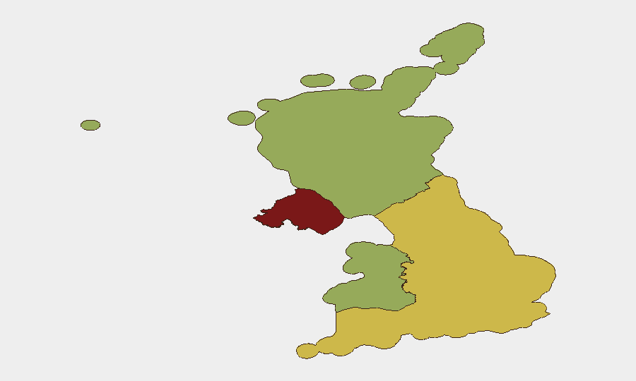
Highest-Risk Areas
Northern Ireland's elevated risk score (85.7) reflects historical communal tensions and ongoing sporadic civil unrest. England (70.9) dominates absolute threat volume due to population density and concentration of financial, political, and infrastructure assets in London and major conurbations; current drivers include protest activity and street-level violent crime. Scotland (59.1) and Wales (55.7) present lower but non-negligible risk, primarily linked to public-order incidents and opportunistic crime around major events and urban centres. Cross-border factors—including the Ireland–UK event signals noted—warrant monitoring but do not yet suggest escalation beyond routine police-level response.
How GeoBit Would Assist
Security teams should activate AOI Monitoring & Early Warning for London, Manchester, Birmingham, Glasgow, and other major urban centres to track protest schedules, police deployments, and transport disruption in real time. Deploy Cyber threat intelligence and OSINT fusion to correlate ransomware targeting patterns against sector-specific organisations and supply-chain vulnerabilities. Use GIS & Spatial Analysis to model travel-route alternatives and staff movement around high-risk areas, particularly in Northern Ireland and England, and integrate conflict & public-order event feeds to anticipate further civil unrest related to economic policy.
7-Day Outlook
Protest activity is likely to continue in major cities as economic policy debates intensify; police resource allocation and public-order management will remain strained. Opportunistic street-level violence appears sporadic rather than organised, but concentration in nightlife districts and transport hubs warrants heightened duty-of-care vigilance. Cyber targeting of UK organisations will persist; incident-response readiness and supply-chain vetting are priorities.
Highest-Risk Areas — Ranked
| # | State / Region | Risk |
|---|---|---|
| 1 | Northern Ireland | 85.7 |
| 2 | England | 70.9 |
| 3 | Scotland | 59.1 |
| 4 | Wales | 55.7 |
Sources
Previous Daily Briefs
A new United Kingdom brief is written every day — each with its own risk map and downloadable CSV. Here's the last week; use the calendar to go further back.
📅 Browse every day by calendar →
Highlighted days have a brief. Tap a day for that day's map & analysis, or “csv” for that day's dataset ($5).