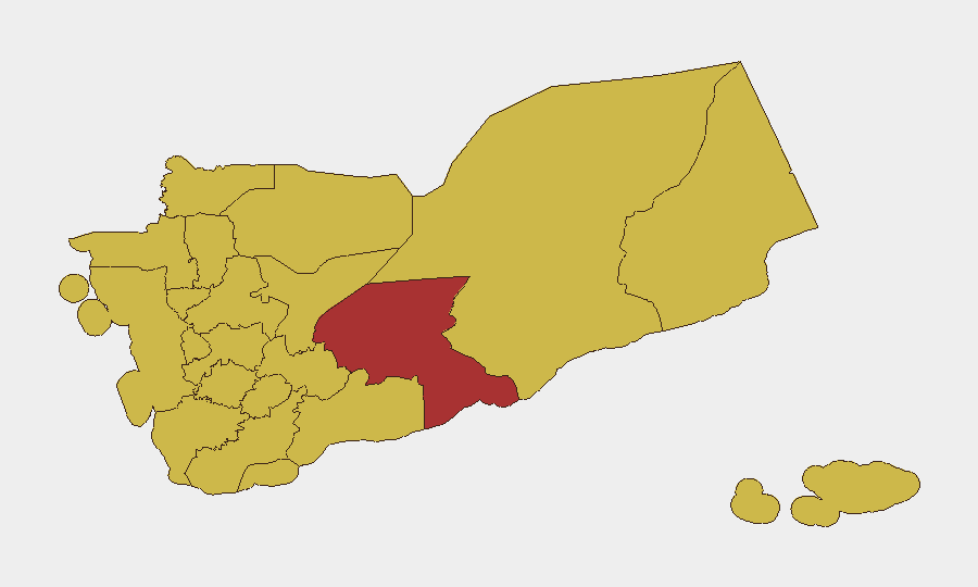
Situation Summary
Yemen remains the world's highest-composite-threat environment, with 98 tracked events and a composite risk score of 100. A significant escalation cycle began on 14 July and intensified over 15–17 July, centered on unauthorized Iranian airspace violations, strikes on Sana'a airport infrastructure, temporary closure of all civilian airports, and retaliatory Houthi missile and drone launches toward Saudi Arabia. The incident reflects deepening friction between the internationally recognized Yemeni government and Houthi-controlled territories, with external powers (Iran, Saudi-led coalition) actively involved in the dispute.
Key Developments
- Sana'a International Airport runway strike (14 July, Amanat Al Asimah). Yemeni government forces struck the runway to prevent an unauthorized Iranian Mahan Air flight from landing, citing breach of sovereignty. The aircraft diverted to Hodeidah.
- Iranian Mahan Air landing at Hodeidah Airport (14 July, Al Hudaydah Governorate). The diverted flight, carrying a Houthi delegation from Tehran, successfully landed on the Red Sea coast despite government objections.
- Nationwide airport closure (14 July, all governorates). Yemen's General Authority of Civil Aviation and Meteorology announced temporary closure of all civilian airports "until further notice" as a precautionary measure. A government crisis-management team was formed and declared continuous session.
- Houthi ballistic missile and drone strikes (14 July, targeting southern Saudi Arabia). Ansar Allah launched retaliatory strikes claiming to target Abha International Airport in retaliation for the Sana'a runway attack. The Saudi-led coalition reported interception with no casualties.
- Coalition air-defense interception (14 July, Saudi southern region). Major General Turki al‑Maliki announced interception of a Houthi ballistic missile threat launched at Saudi Arabia's southern region, part of the same escalation sequence.
- Houthi aviation warning (14 July, national scope). Military spokesperson Yahya Saree issued a public warning to airlines using Saudi airspace to avoid it "before the blockade on Sana'a airport is lifted," explicitly linking the threat to the runway strike and creating near-term aviation risk.
Highest-Risk Areas
Amanat Al Asimah (Sana'a city and capital region, risk 100) is driving maximum risk due to the airport infrastructure strike, government crisis response, and direct involvement in the sovereignty dispute with Iran and Houthi forces. Shabwah Governorate (78.1) remains the second-highest-risk zone, likely reflecting ongoing conventional military activity and fragmented control. The northern corridor—Sa'dah, 'Amran, Sana'a, and Al Jawf governorates (all 70–70.3)—remains elevated due to Houthi operational presence, Iranian logistics, and proximity to Saudi border operations. Coastal zones (Al Hudaydah, 70) present heightened risk owing to port dependency, missile-launch infrastructure, and the diversion of Iranian aircraft to Hodeidah.
How GeoBit Would Assist
Security teams operating in Yemen should deploy persistent area-of-interest (AOI) monitoring on Sana'a airport, Hodeidah port, and major border crossings to detect resumption of civilian or military aviation and alert to further closures or strikes. Multi-language OSINT fusion and entity-extraction analysis of Houthi military statements (Yahya Saree channel, Telegram, radio SIGINT) and Saudi coalition announcements will provide early warning of further retaliatory cycles and aviation threats. Routing and network analysis should be used immediately to map alternative overland and maritime supply chains, given the nationwide airport closure and ongoing missile threats to regional airspace.
7-Day Outlook
Airport closures are expected to remain in effect for at least 5–7 days pending de-escalation or further military incident. Houthi retaliatory cycles typically follow a 48–72-hour rhythm; renewed missile or drone activity toward Saudi Arabia or Yemeni government-held zones is probable if the Iranian airspace breach dispute remains unresolved. Risk of secondary strikes on other critical infrastructure (ports, fuel depots, communications) remains elevated.
Highest-Risk Areas — Ranked
| # | State / Region | Risk |
|---|---|---|
| 1 | Amanat Al Asimah | 100 |
| 2 | Shabwah Governorate | 78.1 |
| 3 | Al Jawf Governorate | 70.3 |
| 4 | Sa'dah Governorate | 70 |
| 5 | Hajjah Governorate | 70 |
| 6 | Al Mahwit Governorate | 70 |
| 7 | Al Hudaydah Governorate | 70 |
| 8 | 'Amran Governorate | 70 |
| 9 | Sana'a Governorate | 70 |
| 10 | Raymah Governorate | 70 |
| 11 | Dhamar Governorate | 70 |
| 12 | Ibb Governorate | 70 |
Sources
Previous Daily Briefs
A new Yemen brief is written every day — each with its own risk map and downloadable CSV. Here's the last week; use the calendar to go further back.
📅 Browse every day by calendar →
Highlighted days have a brief. Tap a day for that day's map & analysis, or “csv” for that day's dataset ($5).
Atlas — our AI intelligence desk — emails them this snapshot personally. Nothing else, no list.