Situation Summary
Mauritania remains classified as a composite-threat environment (score 5) with localized instability concentrated in the remote northeast and eastern border regions. The most recent signal activity (17–19 June) includes diplomatic tension with Mauritius over a prison-related military incident, ongoing investigation activity, and a public statement from Mauritanian authorities. No significant security, civil-unrest, or conflict incidents have been confirmed in the last 24–48 hours within Mauritania's borders; however, an emerging Rift Valley fever alert across Mauritania and Senegal warrants health-sector monitoring.
Key Developments
- Mauritania–Mauritius tension (17–19 June). Reported military-force involvement at a prison facility in relation to Mauritius; diplomatic disapproval signaled by Mauritius authorities and investigative activity ongoing on 18–19 June. Exact location and operational status unclear from available signals.
- Public statement (19 June). Mauritanian government issued a public statement; content unverified; likely related to the Mauritius incident or internal policy matter.
- Investigation—multiple actors (18 June). Law-enforcement and non-state actor investigation initiated; suggests either criminal, administrative, or civil-order incident of unconfirmed scale.
- Rift Valley fever alert (recent). Disease surveillance reports indicate Rift Valley fever activity spanning Mauritania and Senegal; relevant to humanitarian, health-sector, and occupational-safety posture for field operations.
- No active combat, mass-casualty, or terror attack signals reported in the last 24–48 hours; general security posture remains non-acute outside designated high-risk zones.
Highest-Risk Areas
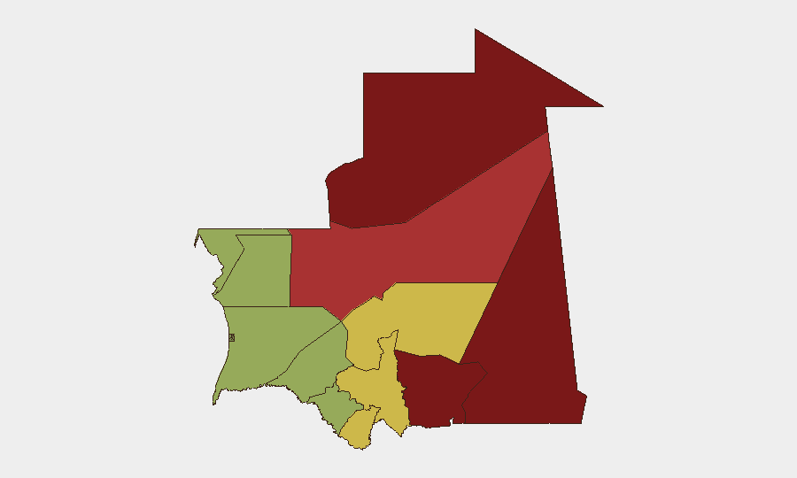
The sub-national ranking is dominated by the Saharan northeast and eastern tier: Tiris Zemmour (95), Hodh Ech Chargui (85), Hodh El Gharbi (80), and Adrar (78) account for the four highest-risk designations and are driven by persistent cross-border militant activity, smuggling networks, and weak state authority. The central-southern regions (Tagant, Guidimaka, Assaba) register moderate to elevated risk (62–68), while the western coastal and Sahel-margin regions (Brakna, Trarza, Dakhlet Nouadhibou) are lower-risk but not risk-free. Corporate assets and personnel operating in the north and east should maintain heightened operational security; the south and west permit standard-duty-of-care protocols, though Rift Valley fever monitoring applies nationwide.
How GeoBit Would Assist
Teams should deploy AOI Monitoring & Early Warning on Tiris Zemmour, Hodh Ech Chargui, and Hodh El Gharbi to detect emerging cross-border militant or trafficking activity. Intel Sweep and multi-language OSINT (X, Telegram, local Arabic and French sources) will track political statements, police activity, and health alerts in real time. Routing & Network Analysis supports secure travel planning around confirmed high-risk zones, while Satellite & Imagery Analysis can verify incident reports and assess infrastructure integrity before personnel deployment.
7-Day Outlook
The Mauritius diplomatic incident is unlikely to escalate to direct kinetic conflict but may sustain investigative and political activity over the next week. Rift Valley fever surveillance should continue; no epidemic trajectory is yet apparent. Operating tempo in Tiris Zemmour and eastern border regions is expected to remain at baseline elevated threat; no major shift in trajectory is forecast unless new militant or state-actor signals emerge.
Highest-Risk Areas — Ranked
| # | State / Region | Risk |
|---|---|---|
| 1 | Tiris Zemmour | 95 |
| 2 | Hodh Ech Chargui | 85 |
| 3 | Hodh El Gharbi | 80 |
| 4 | Adrar | 78 |
| 5 | Tagant | 68 |
| 6 | Guidimaka | 65 |
| 7 | Assaba | 62 |
| 8 | Gorgol | 58 |
| 9 | Trarza | 55 |
| 10 | Inchiri | 52 |
| 11 | Brakna | 48 |
| 12 | Dakhlet Nouadhibou | 45 |
Sources
Previous Daily Briefs
A new Mauritania brief is written every day — each with its own risk map and downloadable CSV. Here's the last week; use the calendar to go further back.
📅 Browse every day by calendar →
Highlighted days have a brief. Tap a day for that day's map & analysis, or “csv” for that day's dataset ($5).