Situation Summary
Mauritania remains a low-frequency security environment (global rank #118; 0 tracked events this week) with a dispersed threat profile concentrated in the eastern and southern borderlands. Cabinet-level institutional change in the capital this week reflects governance and infrastructure challenges rather than acute instability. The security landscape is characterized by persistent border-zone extremist and criminal activity, migrant transit flows, and localized resource-related crime, with no indicators of escalation in the past seven days.
Key Developments
- Nouakchott — 10 October 2026: Prime Minister Mokhtar Ould Djay was reappointed and tasked with forming a new government following the cabinet's resignation. The reshuffle was announced after an inquiry into fires at two major electricity substations in the capital, signaling domestic institutional response to infrastructure vulnerability rather than a security incident per se.
- Nouakchott — 8 October 2026: NATO Southern Neighbourhood Representative Javier Colomina began an official visit focused on regional security cooperation, confirmed by NATO. The visit underscores renewed international engagement on Sahel-region counterterrorism and border-management capacity.
- Nouakchott port — 8 October 2026 (announced): Police announced the seizure of approximately 162,000 ecstasy tablets, four vehicles, and arrest of three foreign nationals in an alleged drug-trafficking operation. The seizure reflects ongoing transnational narcotics trafficking through maritime entry points.
- Nouakchott — 11–12 October 2026: Mauritania's government publicly condemned the attack on King Khalid International Airport in Riyadh, demonstrating diplomatic alignment with regional security concerns. No domestic security incidents were associated with this statement.
- Background context (late September): Arrests of family members of an overseas-based blogger, reportedly connected to alleged financial transfers and blackmail investigations, and a gendarme-led arrest of suspects linked to theft of approximately four kilometers of electricity cable from a major power line, underscore persistent petty-criminal activity and selective enforcement against opposition figures.
Highest-Risk Areas
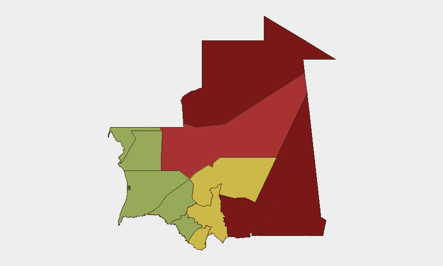
Tiris Zemmour (risk 95), Hodh Ech Chargui (85), and Hodh El Gharbi (80) dominate the risk profile—all eastern and southeastern border regions with Mali, where ungoverned space, AQIM and affiliate presence, and cross-border militant activity create sustained threat conditions. Adrar (78) in the north presents similar transnational militant and smuggling risks. These zones account for the majority of Mauritania's structural security risk; by contrast, the capital and western coastal regions (Dakhlet Nouadhibou, Brakna, Trarza) carry substantially lower but non-negligible threat levels driven by maritime trafficking, irregular migration, and petty crime.
How GeoBit Would Assist
Security teams with operations or personnel in Mauritania would prioritize AOI Monitoring & Early Warning on the four highest-risk regions (Tiris Zemmour, Hodh Ech Chargui, Hodh El Gharbi, Adrar) to detect militant movement, cross-border activity, and trafficking corridors. OSINT fusion and multi-language search across Telegram, local media, and regional feeds provide near-real-time visibility on arrests, security operations, and political developments in Nouakchott. GIS & Spatial Analysis and Routing & Network Analysis enable duty-of-care teams to model safe transit corridors, identify high-risk checkpoints, and plan alternative routes around volatile zones.
7-Day Outlook
No acute security escalation is forecast for the coming week. Institutional reorganization in Nouakchott is routine; international engagement (NATO visit) signals stabilization intent rather than crisis response. Vigilance remains warranted in the eastern border zones, where seasonal militant activity and resource-scarcity-driven crime persist; corporate operations in the capital and coastal areas face only baseline residual risk.
Highest-Risk Areas — Ranked
| # | State / Region | Risk |
|---|---|---|
| 1 | Tiris Zemmour | 95 |
| 2 | Hodh Ech Chargui | 85 |
| 3 | Hodh El Gharbi | 80 |
| 4 | Adrar | 78 |
| 5 | Tagant | 68 |
| 6 | Guidimaka | 65 |
| 7 | Assaba | 62 |
| 8 | Gorgol | 58 |
| 9 | Trarza | 55 |
| 10 | Inchiri | 52 |
| 11 | Brakna | 48 |
| 12 | Dakhlet Nouadhibou | 45 |
Sources
Previous Weekly Briefs
A new Mauritania brief is written every Monday, covering the week — each with its own risk map and downloadable CSV. Use the calendar to go further back.
- October 6, 2026
- September 29, 2026
- September 22, 2026
- September 15, 2026
- September 8, 2026
- September 2, 2026
- August 31, 2026
📅 Browse past briefs by calendar →
Highlighted days have a brief. Tap a day for that day's map & analysis, or “csv” for that day's dataset ($5).
Atlas — our AI intelligence desk — emails them this snapshot personally. Nothing else, no list.