Situation Summary
The Bahamas remains a moderate-risk jurisdiction (global rank #80, composite threat score 21) with sporadic but persistent street violence concentrated in New Providence. Recent August activity shows a clustering of armed homicides and assaults in Nassau's lower-income neighborhoods, consistent with the territory's long-standing challenges of gang-related and transactional crime. No current intelligence suggests systemic instability, major protest activity, or significant governance breakdown; risk is localized and episodic rather than widespread.
Key Developments
- Nassau, Marathon Road (New Providence) – Aug 26, 2026: A violent brawl erupted at a commercial IHOP location and circulated on social media, prompting official restaurant and media response; extent of injuries and police involvement remains unclear from available open sources.
- Nassau, multiple homicides (New Providence) – Aug 22, 2026: Three fatal shootings occurred within 24 hours: a targeted killing on Soldier Road (4 p.m., victim early 50s), a roadside execution of a landscaper on Gladstone Road near a bus stop (noon, victim late 30s), and an indoor homicide at Joe Farrington Road (victim early 50s). All incidents involved armed assailants exiting vehicles and opening fire, indicating organized tactical patterns.
- Exuma offshore operation – Aug 22, 2026: Joint Bahamian Drug Enforcement Unit and U.S. law-enforcement operation (OPBAT) seized 222 pounds of suspected cocaine, a firearm, and ammunition from a vessel; one male (age 43) was identified but not arrested. Seizure reflects ongoing cocaine-trafficking transshipment through Exuma waters.
- Nassau, Farmingdale Road (New Providence) – Aug 21, 2026: Police detained an 18-year-old wanted for armed robbery and arrested two associated suspects, reflecting active targeted crime-suppression enforcement.
- National police operations – weekend Aug 22–24, 2026: An internal police crime-fighting strategy document ("Operation Clean Sweep") was leaked, outlining scheduled road checks and enforcement sweeps; the leak triggered an internal investigation but signaled heightened law-enforcement activity across the country.
Highest-Risk Areas
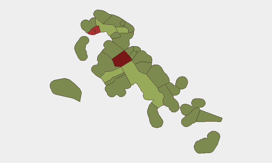
New Providence (risk score 92) dominates the threat landscape, driven by concentrated gang violence, turf-related homicides, and armed robbery in Nassau's Fox Hill, Over-the-Hill, and adjacent neighborhoods. Freeport (risk 78) and Central Abaco (risk 52) show secondary concern, likely reflecting smaller populations and trafficking vulnerability. The clustering of August homicides on Soldier Road, Gladstone Road, and Joe Farrington Road—all within the Nassau metro area—underscores that violence remains hyperlocal and strongly correlated with informal settlements and drug-distribution networks. Travel and asset exposure outside New Providence carries materially lower risk.
How GeoBit Would Assist
Intel Sweep and OSINT fusion capabilities would provide continuous monitoring of local news feeds, police social channels, and community reporting to detect emerging hotspots and incident clusters in real time. AOI Monitoring & Early Warning with persistent watch on high-risk neighborhoods (New Providence, Freeport) would alert security teams to escalations in violence patterns or infrastructure disruptions. Routing & Network Analysis would enable corporate security to pre-plan alternative transportation corridors for staff and assets, bypassing highest-risk street segments identified through spatial analysis.
7-Day Outlook
Violence patterns are expected to remain episodic and localized to New Providence's informal settlements over the near term, with no indicators of territorial escalation or organized criminal reorganization. Heightened police enforcement (Operation Clean Sweep) may temporarily reduce street-level incidents but is unlikely to alter underlying gang or trafficking dynamics. Risk to transiting business personnel and fixed assets remains manageable if movement patterns avoid documented hotspots during daylight and evening peak hours.
Highest-Risk Areas — Ranked
| # | State / Region | Risk |
|---|---|---|
| 1 | New Providence | 92 |
| 2 | City of Freeport | 78 |
| 3 | Central Abaco | 52 |
| 4 | Central Andros | 48 |
| 5 | Exuma | 45 |
| 6 | East Grand Bahama | 42 |
| 7 | South Andros | 38 |
| 8 | North Abaco | 35 |
| 9 | North Eleuthera | 33 |
| 10 | South Abaco | 32 |
| 11 | Cat Island | 30 |
| 12 | Mangrove Cay | 28 |
Sources
Previous Daily Briefs
A new Bahamas brief is written every day — each with its own risk map and downloadable CSV. Here's the last week; use the calendar to go further back.
- August 25, 2026
- August 23, 2026
- August 21, 2026
- August 19, 2026
- August 17, 2026
- August 15, 2026
- August 13, 2026
📅 Browse every day by calendar →
Highlighted days have a brief. Tap a day for that day's map & analysis, or “csv” for that day's dataset ($5).
Atlas — our AI intelligence desk — emails them this snapshot personally. Nothing else, no list.