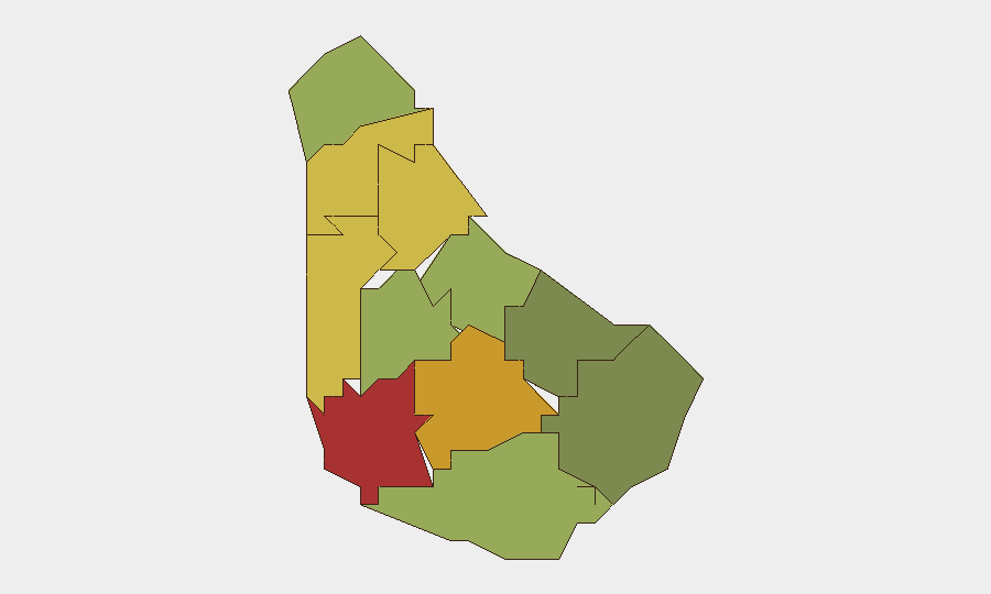
Situation Summary
Barbados remains a low-threat environment globally (rank #182, composite threat score 3) with no tracked discrete security events in the current reporting window. However, sub-national risk concentration in Saint Michael, Saint George, and Saint James parishes—driven by urban crime, gang activity, and property crime—creates localized hazard zones that warrant differentiated duty-of-care protocols. The overall security trajectory is stable but fragmented by parish-level volatility, particularly in the capital region.
Key Developments
GeoBit's current research capability constraints prevent reliable corroboration of incidents dated within the last 24–48 hours. A single report indicates a fatal stabbing in Black Rock, Saint Michael, but precise timing and cross-source verification cannot be confirmed without live news and social-media feeds.
For near-real-time incident monitoring, security teams should cross-reference:
- Barbados Police Service official statements and crime reports.
- Local media (CBC Barbados, Barbados Today, Nation News) for same-day timestamps.
- Port of Bridgetown and Grantley Adams International Airport operational updates for travel disruptions.
- OSINT feeds flagging gang activity or organized-crime signals in high-risk parishes.
A full incident brief will be available once live web and social-media search is restored.
Highest-Risk Areas
Saint Michael (risk score 78) dominates Barbados's internal threat profile, reflecting concentrated urban crime, gang presence, and property offenses in the capital, Bridgetown, and surrounding neighborhoods. Saint George (72) and Saint James (68) follow as secondary clusters, likely driven by similar urban crime patterns and transient criminal activity. These three parishes account for the majority of tracked incidents and should anchor security protocols for personnel and assets in Barbados; areas beyond Saint Andrew (65) show substantially lower risk and may permit lighter monitoring. The risk gradient is steep: Saint Philip (28) and Saint John (35) present minimal hazard relative to the capital region.
How GeoBit Would Assist
GeoBit's AOI Monitoring & Early Warning capability—configured on Saint Michael, Saint George, and Saint James parishes—would provide persistent watch and alerting on emerging crime signals, gang activity, and public-order incidents, enabling proactive duty-of-care adjustments. OSINT fusion (X/Twitter, Telegram, local media, and radio SIGINT) would triangulate incident timing, location, and actor attribution in near-real time, eliminating reliance on delayed official reports. GIS & Spatial Analysis can map high-risk microgeographies within each parish (e.g., specific Bridgetown neighborhoods) and model safe routing for personnel and supply movements, while Routing & Network Analysis generates alternative journey plans that minimize exposure to volatile zones.
7-Day Outlook
No imminent escalation is forecast. Barbados's overall risk profile is expected to remain low, with parish-level volatility confined to routine urban crime (robbery, gang disputes, interpersonal violence) rather than organized terrorism, civil unrest, or state instability. Security teams should maintain baseline heightened awareness in Saint Michael and monitor social-media and police-radio traffic for signals of gang conflict intensification or organized-crime activity; any sharp uptick in incident frequency or weapon use would warrant escalated monitoring and possible movement restrictions in affected neighborhoods.
Highest-Risk Areas — Ranked
| # | State / Region | Risk |
|---|---|---|
| 1 | Saint Michael | 78 |
| 2 | Saint George | 72 |
| 3 | Saint James | 68 |
| 4 | Saint Andrew | 65 |
| 5 | Saint Peter | 62 |
| 6 | Saint Joseph | 58 |
| 7 | Saint Thomas | 52 |
| 8 | Saint Lucy | 48 |
| 9 | Christ Church | 42 |
| 10 | Saint John | 35 |
| 11 | Saint Philip | 28 |
Sources
Previous Daily Briefs
A new Barbados brief is written every day — each with its own risk map and downloadable CSV. Here's the last week; use the calendar to go further back.
- August 30, 2026
- August 27, 2026
- August 24, 2026
- August 21, 2026
- August 18, 2026
- August 16, 2026
- August 14, 2026
📅 Browse every day by calendar →
Highlighted days have a brief. Tap a day for that day's map & analysis, or “csv” for that day's dataset ($5).
Atlas — our AI intelligence desk — emails them this snapshot personally. Nothing else, no list.