Situation Summary
Belize faces a composite threat environment characterized by elevated political and administrative tensions alongside seasonal weather risk. GeoBit event data from June 9–11 signal domestic disapproval actions, territorial disputes with Guatemala, and multiple public statements from government entities, indicating policy friction rather than acute violence or breakdown. No confirmed major security incidents (homicide spikes, armed clashes, infrastructure failures) have been documented in open sources in the last 24–48 hours; however, a tropical weather system warrants operational attention in flood-prone districts.
Key Developments
- Nationwide – Tropical weather risk (June 9, 2026): Belize's National Hydrological Service issued a flood forecast warning of elevated river levels and localized flooding potential due to a tropical wave and regional precipitation. Status is advisory; no confirmed new damage or casualties reported as of June 11.
- Nationwide – Tropical Storm Cristina watch (June 9, 2026): Local media reported monitoring of Tropical Storm Cristina and an adjacent tropical wave system with medium development potential over the next 48 hours. Current impact status remains forecast rather than confirmed incident.
- Belize–Mexico border – Security coordination (recent, June 9–10 window): Military and naval commanders from both nations conducted a border security meeting addressing traditional shared-frontier challenges. No new cross-border incidents were reported; exchange reflects ongoing bilateral cooperation.
- Domestic political friction (June 9–11, 2026): GeoBit event signals document disapproval actions by Belizean groups, government rejection statements, and demands directed at national leadership. Public statements outnumber other signal types; scale and specific locations remain unconfirmed in open reporting.
- Guatemala territorial signal (June 9, 2026): Event data indicate a "territory occupation" signal between Belizean and Guatemalan actors, consistent with longstanding Sarstoon River and border-zone disputes. No escalation to armed confrontation confirmed in current reporting.
Highest-Risk Areas
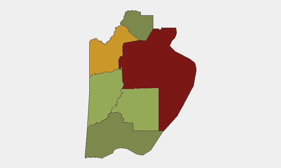
Belize District (composite risk 95) remains the dominant threat driver, reflecting Belize City's persistent gang violence, robbery, and homicide burden despite year-to-date security operations. Orange Walk District (72) follows, with narcotics trafficking and gang activity concentrated along northern supply routes toward Mexico. Cayo District (58) presents secondary concern due to border-zone smuggling and armed-group presence in remote areas. Toledo District (35) and Corozal District (22) carry lower immediate composite scores but warrant monitoring for gang expansion and cross-border spillover respectively. The concentration of risk in Belize District and Orange Walk reflects geographic proximity to trafficking corridors and urban gang territorial control.
How GeoBit Would Assist
Real-time AOI (Area-of-Interest) Monitoring & Early Warning on Belize City, Orange Walk Town, and San Ignacio would provide persistent detection of civil unrest, roadblocks, or gang activity before mainstream media publication. Multi-language OSINT and X/Telegram monitoring of Belizean police statements, NEMO (disaster agency) alerts, and local news outlets enables 24-hour signal capture of security and weather developments without reporting lag. Routing & Network Analysis supports identification of safe alternative travel corridors in high-risk districts and flood-prone areas during tropical weather events.
7-Day Outlook
Political tension and administrative friction are likely to persist through mid-June absent new triggering events. Tropical weather risk remains operationally relevant; continued monitoring of national hydro-meteorological forecasts and localized flood reports is advised for areas in Belize, Orange Walk, and Cayo districts. No trajectory toward armed escalation or nationwide instability is evident in current data; risk remains sub-national and sectoral.
Highest-Risk Areas — Ranked
| # | State / Region | Risk |
|---|---|---|
| 1 | Belize District | 95 |
| 2 | Orange Walk District | 72 |
| 3 | Cayo District | 58 |
| 4 | Stann Creek District | 48 |
| 5 | Toledo District | 35 |
| 6 | Corozal District | 22 |
Sources
Previous Daily Briefs
A new Belize brief is written every day — each with its own risk map and downloadable CSV. Here's the last week; use the calendar to go further back.
📅 Browse every day by calendar →
Highlighted days have a brief. Tap a day for that day's map & analysis, or “csv” for that day's dataset ($5).