Situation Summary
Benin ranks 52nd globally on GeoBit's composite threat index (score 35), reflecting a moderately elevated but stable security environment as of mid-June 2026. The country's risk profile is heavily concentrated in its northern departments, where porous borders with Niger and Nigeria create sustained exposure to jihadist infiltration, trafficking, and cross-border criminal activity. No major security incidents were corroborated in open sources during the last 24–48 hours; the current threat posture reflects chronic structural vulnerabilities rather than acute escalation.
Key Developments
Open-source intelligence for the 24–48 hour window does not reveal clearly verifiable, time-stamped discrete security incidents (attacks, civil unrest, major arrests with security implications, or infrastructure disruptions) that meet publication standards. A 2026-06-16 arrest/detain event was flagged in GeoBit's event stream but requires source verification and location confirmation before inclusion in operational briefing. Two 2026-06-14 demand events involving Benin and the United Kingdom similarly lack sufficient contextual reporting in English-language sources to establish operational relevance to on-ground security.
Recommendation: Security teams should treat the last 48 hours as a *baseline monitoring period* rather than an active incident window. Persistent area-of-interest monitoring (via GeoBit's AOI alerting capability) should remain active on Alibori and Atakora departments and key transport corridors to the Nigerian border.
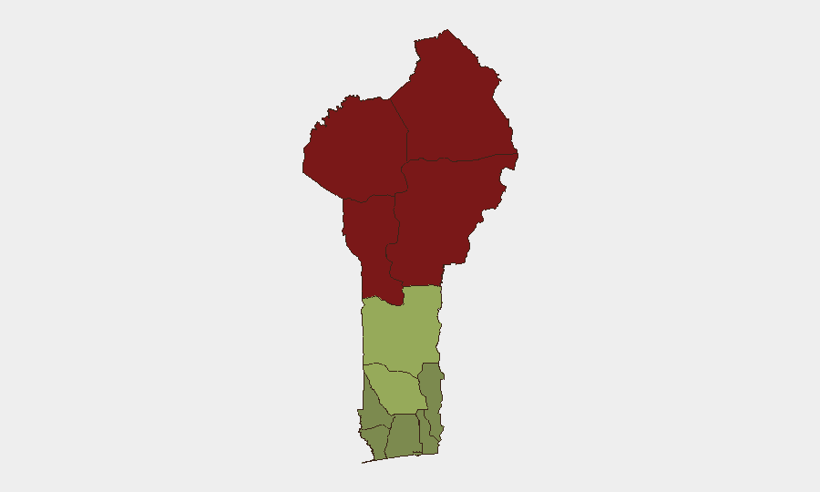
Highest-Risk Areas
Alibori and Atakora departments in Benin's far north (risk scores 92 and 88 respectively) dominate the threat landscape, driven by proximity to Niger and Nigeria's jihadist-affected zones and established trafficking routes. Donga and Borgou departments (scores 85 and 83) extend this northern corridor of elevated risk. Southern and coastal departments—Ouémé, Littoral, and Atlantique (scores 22, 25, 28)—remain comparatively secure but warrant routine monitoring for organized crime and maritime trafficking. Risk is inversely correlated with distance from the Sahel frontier and formal state capacity.
How GeoBit Would Assist
Security teams should operationalize persistent area-of-interest (AOI) monitoring on Alibori, Atakora, and Borgou departments, with automated alerts triggered by conflict, terrorism, weapons, crime, and political-instability keywords. Multi-language OSINT fusion (X/Twitter, Telegram, French-language news, radio SIGINT) will capture incidents before English-language wire reporting, critical for 12–24 hour early warning. Border and network analysis tools enable real-time mapping of threat-actor movements across Niger–Benin and Nigeria–Benin transit zones, informing route-planning and asset-movement decisions for personnel in or transiting northern regions.
7-Day Outlook
No escalation trajectory is evident from current intelligence. Benin's security posture is likely to remain stable over the next week, with routine low-level cross-border criminal and trafficking activity in the north but no anticipated shift in the composite threat ranking. Teams should maintain heightened alertness for spillover effects from any instability in neighboring Niger or Nigeria, where jihadist activity remains operationally active; GeoBit's early-warning capability is best applied at that regional level to anticipate secondary impacts on Benin.
Highest-Risk Areas — Ranked
| # | State / Region | Risk |
|---|---|---|
| 1 | Alibori Department | 92 |
| 2 | Atakora Department | 88 |
| 3 | Donga Department | 85 |
| 4 | Borgou Department | 83 |
| 5 | Zou Department | 45 |
| 6 | Collines Department | 42 |
| 7 | Plateau Department | 38 |
| 8 | Kouffo Department | 35 |
| 9 | Mono Department | 32 |
| 10 | Atlantique Department | 28 |
| 11 | Littoral | 25 |
| 12 | Ouémé Department | 22 |
Sources
Previous Daily Briefs
A new Benin brief is written every day — each with its own risk map and downloadable CSV. Here's the last week; use the calendar to go further back.
📅 Browse every day by calendar →
Highlighted days have a brief. Tap a day for that day's map & analysis, or “csv” for that day's dataset ($5).