Situation Summary
The Republic of Benin remains a low-threat environment overall (global rank #124, composite score 2), with no clearly verified security incidents reported in open sources over the last 24–48 hours. However, northern departments—particularly Alibori, Atakora, Donga, and Borgou—continue to face elevated risk from cross-border activity, banditry, and militant group presence linked to the Sahel instability zone. Southern and coastal regions remain substantially more secure. The threat profile is geographically stratified, with northern border zones requiring heightened monitoring and southern commercial/government centers presenting routine urban risks.
Key Developments
- No independently verified new security incidents in the Republic of Benin were identified in open sources for the 24–48 hour period ending 2026-06-17. Available web reporting and social-media signals do not point to time-stamped, confirmed events meeting current-incident criteria within Benin's borders.
- Confusion with Benin City, Nigeria (Edo State) noted in raw signal traffic. Recent kidnapping incidents on 13–16 June in Benin City, the Benin–Auchi Highway, and Airport Road (Edo State, Nigeria) have circulated widely and may be mistakenly conflated with the Republic of Benin in some corporate or news contexts; these are Nigerian security matters, not Beninese.
- Edo State (Nigeria) security escalation for reference context. The Edo State governor ordered heightened patrols and a "red alert" following kidnappings on 13 June, and police–media collaboration was announced to improve threat alerting; this underscores banditry risk in the immediate Nigeria–Benin border region, though no cross-border spread into Benin has been confirmed.
- Northern Benin (Alibori, Atakora, Donga, Borgou departments) remains the primary risk zone. These departments retain composite risk scores of 83–92, reflecting persistent exposure to Sahel-linked militant activity, smuggling networks, and transnational banditry—a longer-term pattern rather than a new acute incident, but operationally relevant for any personnel or assets in those regions.
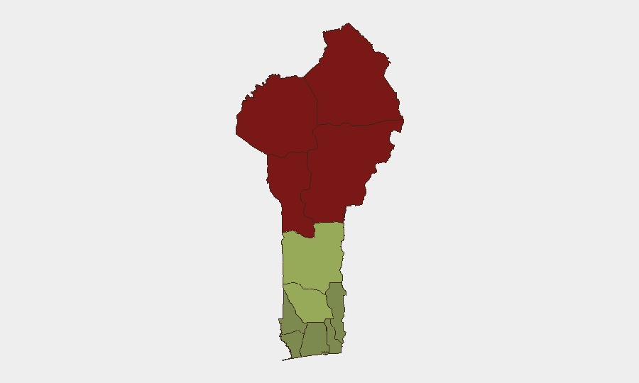
Highest-Risk Areas
Northern Benin's four departments (Alibori, Atakora, Donga, Borgou) drive the country's overall risk profile, with composite scores ranging from 83 to 92. This reflects chronic exposure to cross-border activity from Niger and Burkina Faso, including militant group presence, arms smuggling, and localized banditry—a consequence of Sahel-wide instability rather than internal state collapse. Southern departments (Atlantique, Ouémé, Littoral) remain materially lower-risk, with scores below 30; these zones are home to Benin's commercial capital, ports, and government seats, and face routine urban crime rather than organized conflict. Risk is inverse to population and economic density: the less-populated north bears higher threat, while the more-developed south remains more secure.
How GeoBit Would Assist
Security teams with personnel or assets in Benin should deploy AOI Monitoring & Early Warning for the northern departments (Alibori, Atakora, Donga, Borgou) to track cross-border incident flow and alert on emerging militia or bandit activity. Intel Sweep and OSINT fusion (X/Twitter, Telegram, multi-language web search, and radio SIGINT) would disambiguate Benin-specific threats from noise (e.g., Nigeria incidents) and detect early signals of deterioration. Routing & Network Analysis can identify secure transit corridors and alternative routes for personnel moving in or between northern and southern zones, particularly near Niger and Burkina Faso borders.
7-Day Outlook
No acute escalation is expected in the near term, and Benin's overall threat posture remains stable. However, northern border zones will likely continue to experience low-level banditry and cross-border criminal activity consistent with Sahel regional trends. Southern regions should remain secure for routine business and operations.
Highest-Risk Areas — Ranked
| # | State / Region | Risk |
|---|---|---|
| 1 | Alibori Department | 92 |
| 2 | Atakora Department | 88 |
| 3 | Donga Department | 85 |
| 4 | Borgou Department | 83 |
| 5 | Zou Department | 45 |
| 6 | Collines Department | 42 |
| 7 | Plateau Department | 38 |
| 8 | Kouffo Department | 35 |
| 9 | Mono Department | 32 |
| 10 | Atlantique Department | 28 |
| 11 | Littoral | 25 |
| 12 | Ouémé Department | 22 |
Sources
Previous Daily Briefs
A new Benin brief is written every day — each with its own risk map and downloadable CSV. Here's the last week; use the calendar to go further back.
📅 Browse every day by calendar →
Highlighted days have a brief. Tap a day for that day's map & analysis, or “csv” for that day's dataset ($5).