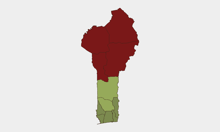
Situation Summary
Benin remains classified as a moderate global security risk (#51 globally, composite score 37), with terrorism as the primary driver concentrated in the far north. No major discrete security incidents were recorded during the reporting week, but multiple developments underscore persistent terrorism threats in border zones and emerging criminal organization activity in the south. The northern school closures and reaffirmed travel warnings signal that armed-extremist activity near Burkina Faso and Niger borders continues to disrupt normal operations and deter travel to those regions.
Key Developments
- Djèrègbé and Sèmè-Podji, Ouémé Department (south-east), 14–15 September 2026: Police arrested five suspected burglars in an organized network, seizing 94 sets of keys, lockpicks, and electronics; follow-up searches recovered jewelry and security cameras, indicating coordinated residential burglary activity in the southern coastal region.
- Northern border communes (10 locations, Alibori, Atakora, Borgou, and Donga departments), 13 September (confirmed 20 September) 2026: Education authorities suspended school openings at the start of the academic year in 10 northern communes due to terrorist-attack fears linked to armed groups operating along Burkina Faso and Niger borders; pupils were redistributed to safer locations.
- National border points and airports, 16 September 2026 (policy announced; confirmed 17–21 September): Ministry of Health ended systematic yellow-fever vaccination certificate checks at all entry points (airport, seaport, land borders); vaccination remains recommended but is no longer enforced at check-in.
- Northern border areas and national parks (Pendjari, W National Park, within 50 km of borders), 19–20 September 2026: Major governments' travel advisories continued to recommend against all travel to northern zones due to armed extremist activity, landmines, ambushes, kidnapping, and IEDs.
- Benin—national economic policy, 20 September 2026: Government announced that replacement of locally produced goods with imports now requires state authorization, signaling tighter economic controls that may increase political-economic friction and protest risk if implementation proves disruptive.
- African national visa exemption, 21 September 2026: Ministry reiterated that nationals of all 53 African Union member states can enter visa-free and circulate for up to 90 days, reinforcing a liberal entry regime that shapes regional mobility and border-management exposure.
Highest-Risk Areas
Alibori, Atakora, Donga, and Borgou departments in the far north dominate the risk ranking (scores 92, 88, 85, and 83 respectively), driven by proximity to Burkina Faso and Niger and confirmed armed-extremist presence including terrorism-linked groups, landmines, and kidnapping cells. Zou (45), Collines (42), and Plateau (38) departments show elevated but secondary risk; southern and coastal departments (Atlantique, Littoral, Ouémé) remain substantially lower-risk zones suitable for routine business and travel, though organized crime in the southeast warrants standard due-diligence monitoring.
How GeoBit Would Assist
Security teams should deploy Intel Sweep and multi-language OSINT feeds to track armed-group movements and attack claims in the far north, coupled with AOI Monitoring & Early Warning on the 10 closed communes and border-crossing points to detect when operations resume. Conflict & Military battle mapping and Satellite & Imagery analysis of national parks and border zones would provide ground-truth verification of extremist positions and IED activity, while Routing & Network Analysis supports safe-corridor planning for personnel movement between southern and central zones.
7-Day Outlook
Northern school closures are likely to persist through late September pending security clearance from military or interior authorities; no announcement of reopening has been published. Criminal-network activity in the south may prompt localized police operations; the new import-authorization policy could trigger trader protests or enforcement friction over the coming weeks if implementation accelerates.
Highest-Risk Areas — Ranked
| # | State / Region | Risk |
|---|---|---|
| 1 | Alibori Department | 92 |
| 2 | Atakora Department | 88 |
| 3 | Donga Department | 85 |
| 4 | Borgou Department | 83 |
| 5 | Zou Department | 45 |
| 6 | Collines Department | 42 |
| 7 | Plateau Department | 38 |
| 8 | Kouffo Department | 35 |
| 9 | Mono Department | 32 |
| 10 | Atlantique Department | 28 |
| 11 | Littoral | 25 |
| 12 | Ouémé Department | 22 |
Sources
Previous Weekly Briefs
A new Benin brief is written every Monday, covering the week — each with its own risk map and downloadable CSV. Use the calendar to go further back.
- September 14, 2026
- September 7, 2026
- September 1, 2026
- August 30, 2026
- August 28, 2026
- August 26, 2026
- August 24, 2026
📅 Browse past briefs by calendar →
Highlighted days have a brief. Tap a day for that day's map & analysis, or “csv” for that day's dataset ($5).
Atlas — our AI intelligence desk — emails them this snapshot personally. Nothing else, no list.