Situation Summary
Botswana remains in a period of relative security stability with no major acute incidents reported in the last 24–48 hours. The country ranks at the lower end of global threat indices (composite score 1), though urban centers—particularly Gaborone—carry elevated localized risk driven by property crime, economic vulnerability, and cross-border trafficking patterns. Recent governance developments (refugee citizenship, residency-by-investment schemes) and persistent rural predator–livestock conflict represent non-acute but ongoing operational considerations.
Key Developments
- Gaborone (national) – 20 June 2026 – UNHCR publicly recognized Botswana's grant of citizenship to long-term refugees on World Refugee Day; no associated civil unrest or security incidents reported. [7]
- Botswana (rural, conservation areas, unspecified localities) – Recent updates on predator–livestock conflict management note ongoing farmer losses and a community kraal-conversion project; no specific new attacks or protests in the last 48 hours documented. [3]
- Botswana (national, governance) – Academic and policy commentary continues on institutional relationships between intelligence and police services; no new operational clash or unannounced enforcement action reported in the immediate window. [1]
- Botswana (national, economic governance) – Risk analysis of new citizenship-by-investment offerings highlights theoretical money-laundering and corruption vectors; no confirmed enforcement action or scandal breach in the last 24–48 hours. [6]
- Country-risk aggregation – Live incident-feed dashboards show no major spikes in terror, civil unrest, or organized crime alerts for Botswana over the last 24 hours. [8]
Assessment: The absence of confirmed, specific incidents in the past 48 hours reflects a stable security environment. Existing risk remains concentrated in urban and transit zones rather than acute, time-sensitive threats.
Highest-Risk Areas
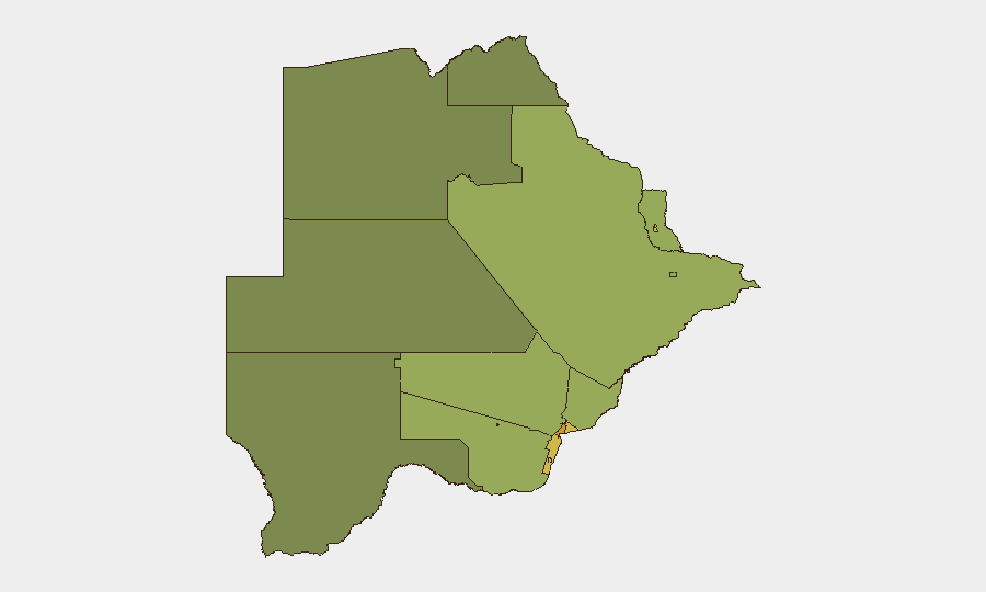
Gaborone (risk 72), South-East District (68), and Lobatse (65) form the highest-risk tier, driven by population density, economic-migration pressures, cross-border smuggling routes, and property/commercial crime prevalence. Francistown and Jwaneng (both 60+) experience similar dynamics, amplified by mining-sector populations and informal-economy vulnerabilities. Lower-risk zones (North-West, Central, North-East Districts: 38–45) reflect reduced urbanization and trafficking throughput but remain subject to rural crime (livestock theft, poaching) and cross-border incursion risks along northern and northwestern boundaries.
How GeoBit Would Assist
Security teams operating in Botswana would deploy Intel Sweep and multi-language OSINT to monitor emerging incidents, trafficking networks, and political developments in real time across open web, social, and radio channels. AOI Monitoring & Early Warning on high-risk districts (Gaborone, South-East, Lobatse) would provide persistent, automated alerting on civil unrest, crime clusters, or cross-border activity spikes. Routing & Network Analysis and GIS & Spatial Analysis enable identification of safer transit corridors and asset-location risk reassessment as conditions evolve.
7-Day Outlook
No near-term escalation in security incidents is anticipated based on current signals and historical patterns. Continued monitoring of Gaborone and cross-border zones (especially in relation to Zimbabwe and South Africa trafficking dynamics) remains prudent; winter seasonal patterns (July–August) may correlate with increased rural stock theft and predator–human conflict. Governance announcements (citizenship, investment policies) are unlikely to trigger acute civil unrest in the forecast window.
Highest-Risk Areas — Ranked
| # | State / Region | Risk |
|---|---|---|
| 1 | Gaborone | 72 |
| 2 | South-East District | 68 |
| 3 | Lobatse | 65 |
| 4 | Francistown | 62 |
| 5 | Jwaneng | 61 |
| 6 | Selebi Phikwe | 58 |
| 7 | Southern District | 55 |
| 8 | Kgatleng District | 50 |
| 9 | Kweneng District | 48 |
| 10 | North-East District | 45 |
| 11 | Central District | 42 |
| 12 | North-West District | 38 |
Sources
Previous Daily Briefs
A new Botswana brief is written every day — each with its own risk map and downloadable CSV. Here's the last week; use the calendar to go further back.
📅 Browse every day by calendar →
Highlighted days have a brief. Tap a day for that day's map & analysis, or “csv” for that day's dataset ($5).