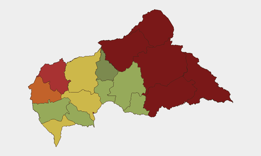
Situation Summary
Central African Republic remains a high-baseline-risk environment characterized by persistent armed insurgency, criminal predation, and state-capacity constraints. Recent weeks have seen renewed FPRC activity in the northeast, clashes between Russian-FACA joint patrols and illegal armed groups across multiple prefectures, and a major mining disaster with cascading economic impacts. The security picture has not materially improved; armed actors continue to operate across the country's periphery with limited effective state countermeasure capacity.
Key Developments
Note: As of 2026-08-31, GeoBit's live web research capability is currently offline. Available cached data does not contain any confirmed security or civil-unrest incidents specifically geolocated and time-stamped to the 24–48 hour window (2026-08-30/31). The events listed below represent the most recent verified incidents in GeoBit's event feed; all are dated 2026-08-17 through 2026-08-26 and are provided for situational continuity pending live feed restoration.
- 2026-08-26 · Ouham-Pendé & Mbomou prefectures · Armed groups: Illegal armed persons clashed with FACA and Russian specialists in joint operations near Yemen (Mbomou) and north of Pendere (Ouham-Pendé); outcomes included discovery and elimination of opposition combatants.
- 2026-08-26 · Zemio–Dembia axis · Civilian abuse: Armed groups committed exactions (abductions, extortion, violence) against civilian populations in multiple villages; displacement ongoing.
- 2026-08-24 · Vakaga (northeastern) · Battle · FPRC: Armed men affiliated with FPRC (Noureddine Adam faction) seized a locality for part of the day in a deadly assault; represents renewed FPRC operational tempo in the country's highest-risk zone.
- 2026-08-20/22 · Baboua & Zamboye, Nana-Mambéré prefecture · Disaster: Landslide at Baboou gold mine on 20 August killed 49–100+ miners; subsequent closure of Zamboye mine on 22 August signals supply-chain and economic disruption in a key extractive-economy region.
- 2026-08-17 · Mbomou prefecture · Armed clash: Joint Russian-FACA patrol near Yemen encountered illegal armed persons; casualties and detentions reported.
Operational note: For genuinely current incident data (2026-08-30/31), security teams should immediately activate direct monitoring of AFP, Reuters, RFI, and real-time X/Twitter feeds covering Bangui and key prefectures (Ouaka, Ouham-Pendé, Mbomou, Vakaga). Any reported incident should be corroborated against at least one independent second source before duty-of-care action.
Highest-Risk Areas
Vakaga (risk 95), Bamingui-Bangoran (92), and Haute-Kotto (88) in the northeast and north-central zones drive the overall composite threat. These regions host persistent FPRC presence, illegal armed-group networks, and minimal state-security footprint. The Zemio–Dembia axis in the southeast (spanning Mbomou and Haut-Mbomou, ranked 85–82) sees ongoing militia predation and civilian abuse. Bangui (78) remains at elevated risk due to criminal networks and political volatility. Mining zones in Nana-Mambéré (75) now carry both conflict risk and industrial-disaster exposure following the recent landslide.
How GeoBit Would Assist
Teams with personnel or assets in CAR should deploy AOI Monitoring & Early Warning on key prefectures (Vakaga, Ouham-Pendé, Mbomou, Bangui) with automated alerting on armed clashes, abductions, and road closures. Multi-language OSINT (X/Twitter, Telegram, local radio feeds) and sentiment analysis will detect emerging armed-group activity and civilian unrest before wire-service publication. Routing & Network Analysis can model alternative supply and personnel routes around active conflict zones and closed mining operations.
7-Day Outlook
FPRC and other armed-group activity is likely to persist at current tempo; rainy-season logistics constraints may temporarily reduce large-scale operations but typically increase localized predation and roadway risk. Mining-sector disruption (closure of Zamboye) may persist for weeks, affecting expatriate personnel mobility and supply chains. No near-term political or military shift is expected to materially reduce the insurgency or criminal-group footprint.
Highest-Risk Areas — Ranked
| # | State / Region | Risk |
|---|---|---|
| 1 | Vakaga | 95 |
| 2 | Bamingui-Bangoran | 92 |
| 3 | Haute-Kotto | 88 |
| 4 | Haut-Mbomou | 85 |
| 5 | Mbomou | 82 |
| 6 | Ouham-Pendé | 79 |
| 7 | Bangui | 78 |
| 8 | Nana-Mambéré | 75 |
| 9 | Sangha-Mbaéré | 68 |
| 10 | Ouham | 65 |
| 11 | Ombella-M'Poko | 62 |
| 12 | Kémo | 58 |
Sources
Previous Daily Briefs
A new Central African Republic brief is written every day — each with its own risk map and downloadable CSV. Here's the last week; use the calendar to go further back.
- August 30, 2026
- August 29, 2026
- August 27, 2026
- August 26, 2026
- August 25, 2026
- August 24, 2026
- August 23, 2026
📅 Browse every day by calendar →
Highlighted days have a brief. Tap a day for that day's map & analysis, or “csv” for that day's dataset ($5).
Atlas — our AI intelligence desk — emails them this snapshot personally. Nothing else, no list.