Situation Summary
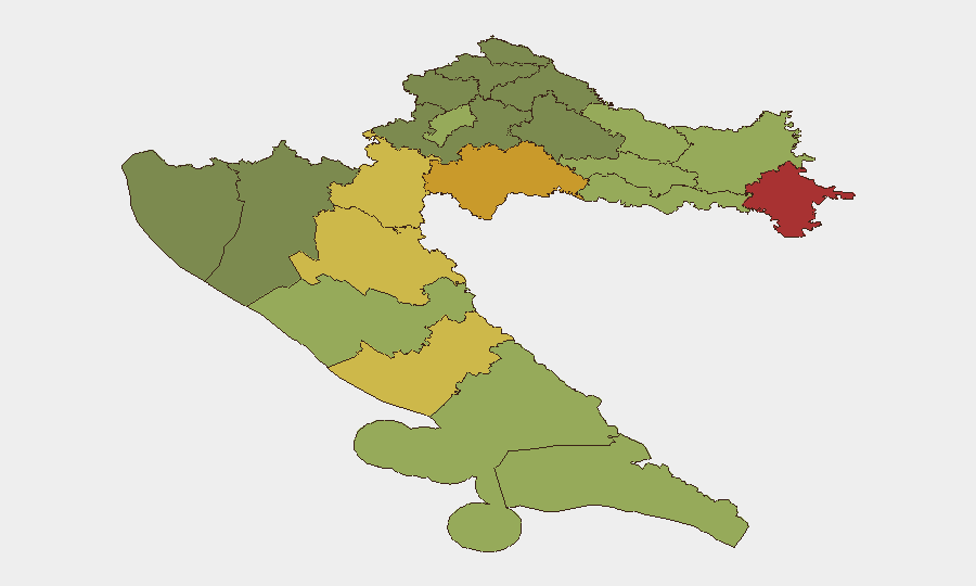
Croatia remains a low-threat jurisdiction (rank 161 globally, composite score 7), with no tracked security events in the current window. The past week registered routine crime, traffic incidents, and a major wildfire in the Adriatic, but no organized threats, civil unrest, or infrastructure attacks. Risk remains concentrated in the northeastern border counties—legacy of regional instability—while coastal and central regions show substantially lower exposure.
Key Developments
- Brač Island (Milna area) — September 16: A major wildfire consumed approximately 3,500 hectares and forced evacuation of 500–700 people, including resort guests and foreign tourists, by sea. Recovery and containment operations continue.
- Zagreb A3 motorway (Otok Svibovski–Zagreb East) — September 16: A five-vehicle collision killed one person and caused multi-kilometre congestion; significant disruption to regional transport corridor.
- Šibenik — September 16: A 24-year-old man is facing murder and attempted murder charges following a fatal stabbing of a Biograd resident and injury to a second person.
- Smokovići, near Zadar — September 16: A head-on collision involving a Polish family resulted in serious injury to a woman and driver, and minor injury to a child; the allegedly responsible driver was located in hospital after reportedly leaving the scene.
- Rijeka (Trsat) — September 22: Police arrested a 25-year-old fugitive on suspicion of attempted murder, evidence concealment, unlawful entry, and drug possession.
- Island of Unija, Rijeka County — September 16: Police reported a 64-year-old man allegedly struck another person in the head with a stick during an altercation.
- Zagreb (Trešnjevka) — September 16: A taxi driver aggressively confronted a ZET bus operator near Selska–Ozaljska intersection; incident video circulated on social media, indicating minor civic friction but no broader disorder.
Highest-Risk Areas
Vukovar-Srijem, Sisak-Moslavina, and Karlovac counties (risk scores 78, 72, and 68 respectively) remain the highest-risk areas, reflecting post-conflict legacies, border proximity to Serbia, and persistent organized-crime and weapons networks in the former conflict zone. Lika-Senj and Šibenik-Knin counties follow (65 and 62), driven by similar geographic and historical factors. Zagreb and the coastal regions score substantially lower (50 and below), indicating that risk is geographically concentrated in the northeast and that routine crime and accident rates drive overall national exposure rather than organized threats.
How GeoBit Would Assist
Security teams with personnel or assets in Croatia would benefit from AOI Monitoring & Early Warning on the highest-risk northeastern counties (Vukovar-Srijem, Sisak-Moslavina, Karlovac) to detect shifts in criminal or hybrid activity; Intel Sweep and multi-language OSINT to track cross-border flows and organized networks; and Routing & Network Analysis to identify safe alternative routes around border regions and high-incident transport corridors during operational planning. Satellite & Imagery analysis supports monitoring of the wildfire-affected Brač region and reconstruction timelines.
7-Day Outlook
No imminent escalation is expected. Routine crime, traffic incidents, and weather-driven risks (wildfire season ongoing) will likely persist. The wildfire recovery on Brač may disrupt tourism and hospitality operations for 1–2 weeks; northeast counties will remain under standard monitoring due to structural (not acute) risk factors.
Highest-Risk Areas — Ranked
| # | State / Region | Risk |
|---|---|---|
| 1 | Vukovar-Srijem County | 78 |
| 2 | Sisak-Moslavina County | 72 |
| 3 | Karlovac County | 68 |
| 4 | Lika-Senj County | 65 |
| 5 | Šibenik-Knin County | 62 |
| 6 | Brod-Posavina County | 58 |
| 7 | Zadar County | 55 |
| 8 | Osijek-Baranja County | 52 |
| 9 | City of Zagreb | 50 |
| 10 | Split-Dalmatia County | 48 |
| 11 | Požega-Slavonia County | 45 |
| 12 | Virovitica-Podravina County | 42 |
Sources
Previous Weekly Briefs
A new Croatia brief is written every Monday, covering the week — each with its own risk map and downloadable CSV. Use the calendar to go further back.
- September 15, 2026
- September 9, 2026
- September 3, 2026
- August 31, 2026
- August 28, 2026
- August 26, 2026
- August 24, 2026
📅 Browse past briefs by calendar →
Highlighted days have a brief. Tap a day for that day's map & analysis, or “csv” for that day's dataset ($5).
Atlas — our AI intelligence desk — emails them this snapshot personally. Nothing else, no list.