Situation Summary
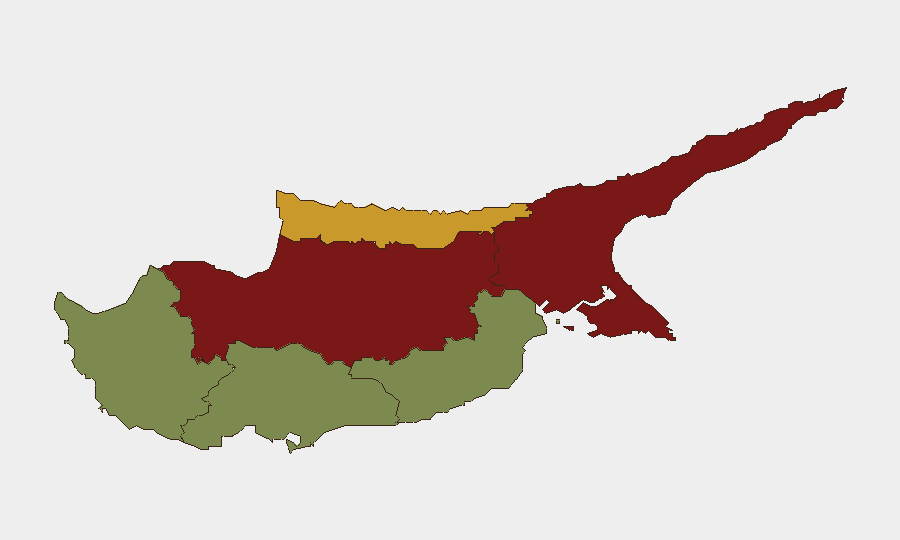
Cyprus remains a low-threat environment with no credible security incidents, civil unrest, or political violence documented in the last 24–48 hours. Police operations across the island during this period were routine and preventive in nature, focused on traffic enforcement, immigration compliance, and minor crime suppression. The sub-national risk landscape is heavily skewed toward the divided Nicosia district and Turkish-administered northern areas (Famagusta, Kyrenia), while southern population centers (Larnaca, Limassol, Paphos) present minimal operational risk. Overall threat trajectory remains stable.
Key Developments
- Island-wide police operations (Nicosia district and nationwide, overnight 27–28 July 2026): Cyprus Police conducted coordinated night-time enforcement across "key points of urban areas," resulting in 12 arrests (drunkenness, drug possession, assault, illegal stay, theft) and 9 vehicle seizures. 383 drivers and 175 passengers were checked, with 180 traffic violations and 42 speeding offences recorded. No violent incidents or organized crime events were noted.
- Immigration enforcement sweep (Nicosia and Larnaca districts, 27 July 2026): The Aliens and Immigration Service, working with Green Line Surveillance units, arrested 19 individuals for illegal residence in the Republic during coordinated checks. Operation was routine and completed without incident.
- Proactive policing posture (nationwide, last 24–48 hours): Police presence described as "intense" across Cyprus with emphasis on serious-crime prevention and public-order maintenance. Activity reflects standard enforcement rhythm rather than response to specific threats or incidents.
- No confirmed destabilizing events (assessment period ending 28 July 2026): Independent review of open sources confirms absence of violent incidents, infrastructure attacks, civil unrest, or terrorism in the last 24–48 hours across the Republic.
- Routine crime activity (ongoing, week of 22–28 July 2026): Drug seizures, tobacco smuggling interceptions, and traffic-safety operations continue as part of standard law-enforcement activity. No anomalies or escalations reported.
Highest-Risk Areas
Nicosia (risk score 92) and Famagusta (88) dominate the sub-national ranking, reflecting structural political risk tied to the island's division and the presence of the UN Buffer Zone; both areas carry significantly higher exposure to political tension and potential security incidents than the rest of the island. Kyrenia (72) similarly reflects northern-zone volatility. In contrast, southern districts—Larnaca (28), Limassol (22), and Paphos (18)—present substantially lower composite risk, driven by distance from the Green Line, stable governance, and routine crime profiles. Organizations and personnel in Nicosia should maintain heightened situational awareness and contingency plans; southern operations face minimal geographic risk.
How GeoBit Would Assist
Security teams managing Cyprus operations would leverage AOI Monitoring & Early Warning on high-risk districts (Nicosia, Famagusta, Kyrenia) to detect shifts in police activity, protest activity, or cross-border tension before they escalate. Intel Sweep and multi-language OSINT (X/Twitter, Telegram, local news feeds) provide real-time intelligence on political statements, civil unrest, and Turkish-Cypriot activity. Routing & Network Analysis enables duty-of-care teams to plan alternative routes away from the Green Line and higher-risk urban zones for personnel movement.
7-Day Outlook
No near-term destabilization is forecast; Cyprus is expected to remain in a low-threat, stable policing environment over the next week. Routine enforcement activity and minor crime will likely continue. Risk remains concentrated in Nicosia and the north; southern operations face minimal change in threat profile.
Highest-Risk Areas — Ranked
| # | State / Region | Risk |
|---|---|---|
| 1 | Nicosia | 92 |
| 2 | Famagusta | 88 |
| 3 | Kyrenia | 72 |
| 4 | Larnaca | 28 |
| 5 | Limassol | 22 |
| 6 | Paphos | 18 |
Sources
Previous Daily Briefs
A new Cyprus brief is written every day — each with its own risk map and downloadable CSV. Here's the last week; use the calendar to go further back.
📅 Browse every day by calendar →
Highlighted days have a brief. Tap a day for that day's map & analysis, or “csv” for that day's dataset ($5).
Atlas — our AI intelligence desk — emails them this snapshot personally. Nothing else, no list.