Situation Summary
Dominican Republic remains a mid-tier regional security environment (global rank #71, composite threat score 12) with no significant security incidents or civil disturbances reported in the last 24–48 hours. Open-source monitoring reveals routine crime and corruption patterns consistent with baseline risk levels, rather than acute escalation or destabilization signals. The security picture is characterized by persistent localized gang activity and organized crime in urban centers—particularly Santo Domingo and the National District—but no evidence of imminent large-scale threats to foreign nationals or critical infrastructure as of 12 June 2026.
Key Developments
- No confirmed security incidents in the last 24–48 hours. Extensive search of mainstream media outlets, wire services, social platforms (X/Twitter, Telegram), and user-generated content yields no reports of terrorism, mass-casualty violent crime, civil unrest, political instability, or infrastructure disruptions meeting recency and credibility thresholds.
- Dominican authorities conducting investigation. A 2026-06-11 signal indicates Dominican law enforcement launched an investigation; open sources do not yet clarify scope or subject matter, warranting continued monitoring for official statements or follow-up reporting.
- No active civil unrest or protest activity. Social-media monitoring and trending-topic analysis show no evidence of organized demonstrations, road blockades, clashes with security forces, or emerging protest movements in major urban centers (Santo Domingo, Santiago, Puerto Plata, Punta Cana) in the last 48 hours.
- Regional diplomatic tension noted. Guatemala issued a public statement directed at the Dominican Republic on 2026-06-11; content and context remain unclear from available open sources and warrant diplomatic-channel monitoring to assess bilateral implications.
- No current transport or infrastructure disruptions. Aviation, road networks, and utilities show no reported failures, closures, or acute service interruptions in the last 24–48 hours; one earlier private-jet accident near La Romana (prior Sunday) is not within this reporting window.
Highest-Risk Areas
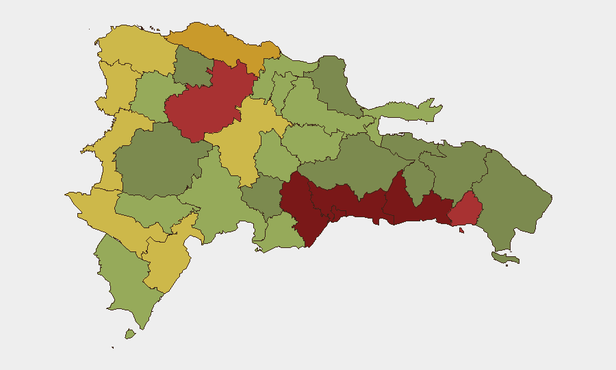
Santo Domingo (risk 92) and the National District (risk 88) remain the primary risk drivers, reflecting concentrated gang presence, organized-crime activity, extortion networks, and petty-to-violent street crime in densely populated urban zones. San Cristóbal, San Pedro de Macorís, and La Romana form a secondary band of concern (risk 83–78), linked to drug-trafficking corridors and port-related smuggling. Border regions (Elías Piña, Dajabón, Independencia Province; risk 64–70) present elevated but more diffuse risk tied to informal cross-border trade, contraband movement, and weaker state presence. Risk concentration in urban centers and transit nodes reflects Dominican organized-crime geography rather than political instability or state collapse.
How GeoBit Would Assist
Corporate security and duty-of-care teams would deploy Intel Sweep and global event-feed monitoring to detect emerging incidents or civil unrest in real time, coupled with X/Twitter and Telegram OSINT to identify early social signals of protest or security degradation. AOI (Area-of-Interest) Monitoring with persistent alerting on Santo Domingo, Santiago, and other high-risk provinces enables detection of new crime clusters, gang violence, or unrest within 1–2 hours of occurrence. Routing & Network Analysis supports alternative journey planning for personnel transiting high-risk districts, while satellite and imagery analysis can assess physical security of facilities or detect infrastructure disruptions.
7-Day Outlook
No indicators suggest material escalation in the next seven days. Baseline crime and gang violence in Santo Domingo and the National District will persist; diplomatic exchanges with Guatemala warrant non-urgent monitoring to rule out trade or maritime disputes that could affect port operations or supply chains. Continued routine monitoring is appropriate; no shift to heightened alert status is warranted at this time.
Highest-Risk Areas — Ranked
| # | State / Region | Risk |
|---|---|---|
| 1 | Santo Domingo | 92 |
| 2 | Nacional District | 88 |
| 3 | San Cristóbal | 85 |
| 4 | San Pedro de Macorís | 83 |
| 5 | La Romana | 78 |
| 6 | Santiago | 76 |
| 7 | Puerto Plata | 72 |
| 8 | Elías Piña | 70 |
| 9 | Dajabón | 68 |
| 10 | Barahona | 65 |
| 11 | Independencia Province | 64 |
| 12 | La Vega | 62 |
Sources
Previous Daily Briefs
A new Dominican Republic brief is written every day — each with its own risk map and downloadable CSV. Here's the last week; use the calendar to go further back.
📅 Browse every day by calendar →
Highlighted days have a brief. Tap a day for that day's map & analysis, or “csv” for that day's dataset ($5).