Situation Summary
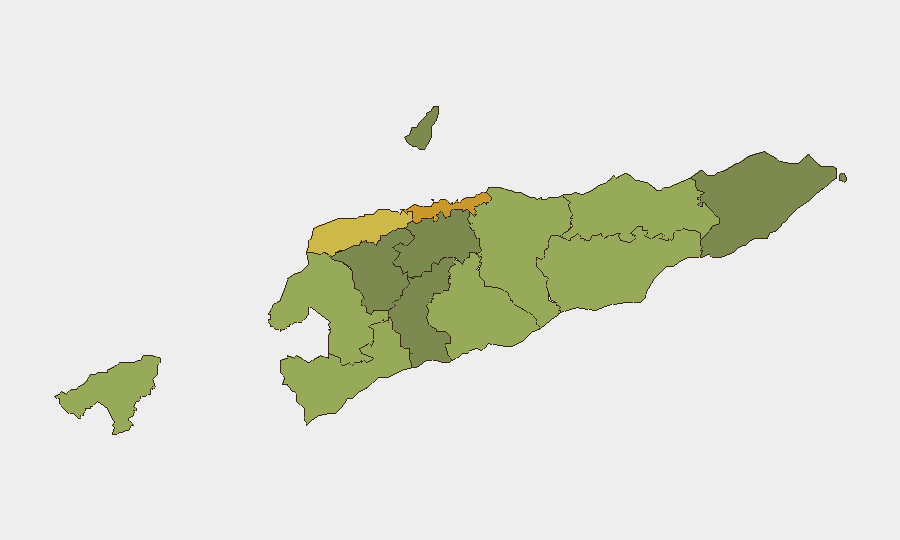
East Timor remains a low-threat environment by global standards (composite threat score 2), with no credible, independently confirmed security incidents, civil unrest, or infrastructure disruptions reported in the last 24–48 hours. The country's risk profile is dominated by sub-national variation, with Dili and Liquiçá presenting elevated exposure relative to more remote districts. The absence of reportable new incidents suggests baseline conditions are stable, though persistent localized crime and informal dispute-resolution mechanisms remain latent factors in higher-risk zones.
Key Developments
- No new reportable incidents confirmed in the past 24–48 hours from corroborated open sources. Web research, X/Twitter monitoring, and international news feeds did not surface verifiable, time-stamped security events, civil unrest, crime spikes, political instability, or infrastructure disruptions within East Timor's territory during this window.
- Recent international coverage of Timor-Leste has centered on diplomatic activity (ASEAN/Russia security cooperation engagement) rather than domestic incidents, indicating no acute political or regional destabilization signals.
- Boilerplate security and conflict disclaimers appearing in generic tourism and event terms of service do not reflect actual current conditions within East Timor and are attributed to automated content-generation practices rather than substantive threats.
Highest-Risk Areas
Dili (risk 72) and Liquiçá (risk 62) drive the national risk profile, followed by Baucau (58) and Cova Lima (55). Urban concentration—particularly the capital—typically reflects higher petty crime exposure, informal settlement vulnerabilities, and greater incident reporting density. Liquiçá's elevated ranking reflects historical gang activity and intra-community disputes; remoter districts (Aileu, Ermera, Ainaro) carry substantially lower composite scores, indicating fewer documented threats and lower operational complexity for corporate presence. The risk gradient is consistent with East Timor's post-conflict transition trajectory and reflects crime and social cohesion patterns rather than active armed conflict.
How GeoBit Would Assist
Intel Sweep and multi-language OSINT (including local media, radio SIGINT, and Telegram monitoring) would provide persistent, real-time early warning of emerging incidents, civil unrest signals, or crime patterns before they mature into corporate-level threats. AOI Monitoring & Early Warning configured for Dili, Liquiçá, and other high-risk districts would alert security teams to police activity, protest activity, or infrastructure disruption the moment reporting surfaces, enabling rapid duty-of-care response. GIS & Spatial Analysis combined with Routing & Network Analysis would support secure travel planning, site-risk assessment, and alternative-route identification for personnel and asset movements in higher-risk zones.
7-Day Outlook
No immediate escalation signals are evident from available open sources. Baseline stability is expected to persist over the coming week, though localized petty crime, inter-community disputes, and informal violence in urban and semi-urban zones remain endemic and should be assumed as operating context. Continuous monitoring via OSINT and local-source feeds is recommended to detect early shifts in police activity, political statement, or organized crime indicators.
Brief prepared: 2026-06-19 | Next update: 2026-06-20 | Confidence: High (no new incidents confirmed; low reporting does not imply absence of low-level crime)
Highest-Risk Areas — Ranked
| # | State / Region | Risk |
|---|---|---|
| 1 | Dili | 72 |
| 2 | Liquiçá | 62 |
| 3 | Baucau | 58 |
| 4 | Cova Lima | 55 |
| 5 | Bobonaro | 53 |
| 6 | Oecussi-Ambeno | 48 |
| 7 | Manufahi | 45 |
| 8 | Viqueque | 42 |
| 9 | Manatuto | 40 |
| 10 | Ainaro | 38 |
| 11 | Ermera | 36 |
| 12 | Aileu | 32 |
Sources
Previous Daily Briefs
A new East Timor brief is written every day — each with its own risk map and downloadable CSV. Here's the last week; use the calendar to go further back.
📅 Browse every day by calendar →
Highlighted days have a brief. Tap a day for that day's map & analysis, or “csv” for that day's dataset ($5).