Situation Summary
Eritrea remains a stable, low-incident jurisdiction (global rank #79, composite threat score 24), with no discrete security events recorded inside the country during the past week. However, the security environment has shifted materially due to escalating conflict in adjacent northern Ethiopia and alleged Eritrean involvement in that theater. The proximity of fighting to Eritrea's borders, combined with unverified allegations of Eritrean military support for Ethiopian opposition forces, creates a secondary risk of wider regional escalation that could affect cross-border operations and travel.
Key Developments
- 23 Sep — Tigray Region, Ethiopia (Mekelle, three regional airports): Tigrayan forces seized three airports and clashed with Ethiopian federal troops in the sharpest escalation in months. Ethiopian officials alleged Eritrean financial and material backing for the armed alliance; Eritrea denied involvement. This marks a material change in the Ethiopia–Eritrea security relationship and poses spillover risk to Eritrean territory.
- 23 Sep — US Sanctions Environment: The United States removed key Eritrean individuals and entities from its sanctions list shortly before the Tigray escalation, altering Eritrea's external financial and diplomatic risk profile. The timing and implications for future sanctions exposure remain uncertain.
- 25–28 Sep — Northern Ethiopia Border Zone: Ethiopian military and regional officials made public allegations that Eritrea, Sudan, and Egypt are supporting Ethiopian opposition forces, with claims of direct Eritrean military participation in Afar fighting and efforts to sever Ethiopia–Djibouti transport routes. No independently verified evidence of Eritrean forces operating inside Ethiopia has been published; Eritrea has denied all allegations.
- 23–28 Sep — Ethiopian Aviation Disruption: Ethiopian Airlines suspended or cancelled flights to northern Ethiopian destinations including Mekelle, disrupting transit options for personnel operating near the Eritrea–Ethiopia border corridor.
Highest-Risk Areas
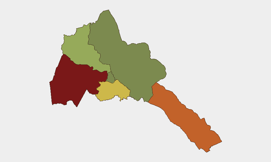
Gash-Barka (risk 92) and Southern Red Sea Region (risk 75) remain Eritrea's highest-risk zones, driven by border proximity to active conflict in Ethiopia and Sudan, limited state presence, and smuggling activity. Debub Region (risk 68) ranks third, reflecting similar cross-border vulnerabilities. These three regions account for the bulk of assessed country risk; by contrast, Maekel Region (the capital area, risk 18) and Northern Red Sea Region (risk 0) are significantly more stable. Organizations with operations or personnel in the western and southern border zones face elevated exposure to cross-border conflict spillover, population displacement, and potential military activity, particularly if allegations of Eritrean involvement in Ethiopian fighting are substantiated.
How GeoBit Would Assist
Security teams managing duty-of-care in Eritrea would employ AOI Monitoring & Early Warning on the Gash-Barka and Southern Red Sea border zones to detect cross-border military movement, refugee flows, or weapons transit with live alerting. Routing & Network Analysis would identify alternative logistics and evacuation routes that avoid border flashpoints and disrupted Ethiopian transport corridors. Intel Sweep, OSINT fusion, and multi-language search (including Arabic and Tigrinya) would track state media, opposition channels, and regional social platforms for escalation signals or policy shifts that affect cross-border access and sanctions exposure.
7-Day Outlook
The Ethiopia–Tigray conflict is likely to sustain elevated rhetoric and unverified allegations regarding Eritrean involvement over the coming week, driven by Ethiopian federal messaging and international media interest. No imminent direct Eritrean military action inside Eritrea is indicated by available reporting. However, the risk of border incidents, refugee surges into western Eritrea, and aviation/transit delays affecting the Ethiopia–Djibouti corridor remains elevated through early October.
Highest-Risk Areas — Ranked
| # | State / Region | Risk |
|---|---|---|
| 1 | Gash-Barka | 92 |
| 2 | Southern Red Sea Region | 75 |
| 3 | Debub Region | 68 |
| 4 | Anseba | 55 |
| 5 | Maekel Region | 18 |
| 6 | Northen Red Sea Region | 0 |
Sources
Previous Weekly Briefs
A new Eritrea brief is written every Monday, covering the week — each with its own risk map and downloadable CSV. Use the calendar to go further back.
- September 22, 2026
- September 15, 2026
- September 8, 2026
- September 2, 2026
- August 31, 2026
- August 29, 2026
- August 27, 2026
📅 Browse past briefs by calendar →
Highlighted days have a brief. Tap a day for that day's map & analysis, or “csv” for that day's dataset ($5).
Atlas — our AI intelligence desk — emails them this snapshot personally. Nothing else, no list.