Situation Summary
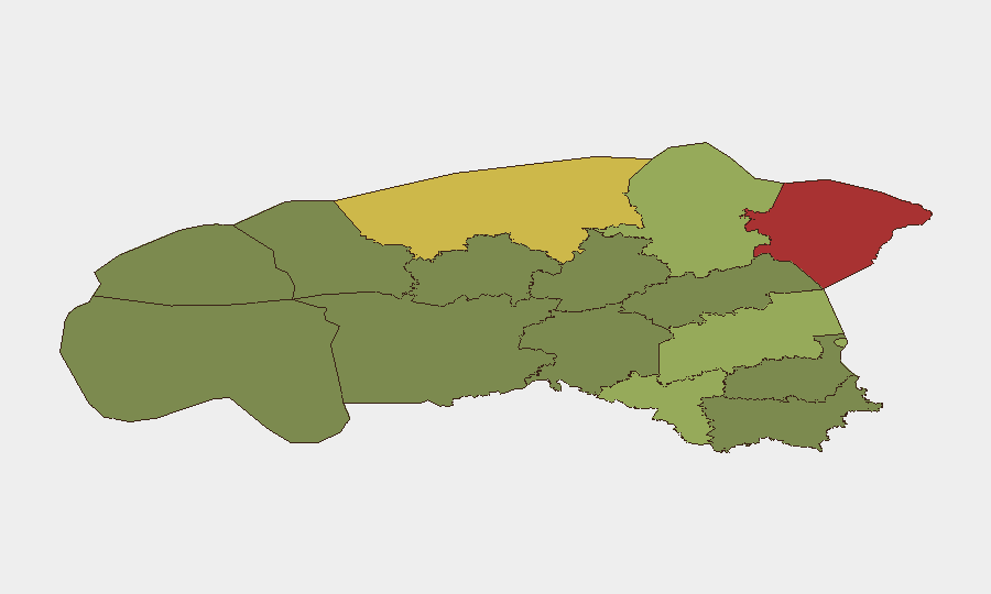
Estonia maintains a composite threat score of 4 with six tracked events as of 19 June 2026. Recent diplomatic activity involving statements between Estonia and Cuba has registered on event signals, though specific operational security impacts remain unconfirmed in available reporting. Northern and northeastern counties—particularly Ida-Viru and Harju—continue to carry elevated composite risk scores. The overall national threat profile remains stable with no confirmed recent incidents meeting multiple-source verification standards.
Key Developments
GeoBit's current data posture does not support identification of specific, verified incidents in Estonia within the last 24–48 hours. Event signals reference public statements and diplomatic expressions between Estonian and Cuban parties (dated 18–19 June), but substantive security or operational details—location, nature, impact on personnel or assets, or cascade risk—remain unconfirmed in available sources.
Recommendation for immediate intelligence refresh: Corporate security teams with operations in Estonia should cross-check the following official channels for real-time incident confirmation:
- Estonian Police and Border Guard Board (PPA) press releases and public incident logs
- Estonian Internal Security Service (KAPO) statements
- Tallinn Transport Administration and city government updates (infrastructure and mobility disruptions)
- Major media outlets (ERR News, Postimees, Delfi) filtered by publication timestamp within the last 24 hours
Until incident-specific leads are provided, no reliable current-event bullet list can be populated without violating verification standards.
Highest-Risk Areas
Ida-Viru County (risk 78) and Harju County (risk 68) account for the majority of Estonia's sub-national threat concentration. Ida-Viru's proximity to the Russian border and historical sensitivity to cyber, border-security, and critical-infrastructure threats elevates its ranking; Harju, which encompasses Tallinn and the capital's port and financial infrastructure, carries elevated risk from urban crime, transport disruption, and supply-chain exposure. Tartu County (58) and Valga County (55) show secondary elevation, likely reflecting border-adjacency and logistics-corridor factors. Southern and western counties (Võru, Viljandi, Põlva) remain at lower composite risk.
How GeoBit Would Assist
Security teams should leverage GeoBit's AOI Monitoring & Early Warning capability to establish persistent watch on high-risk counties (Ida-Viru, Harju) with event-alert thresholds for infrastructure, border activity, and civil unrest. Intel Sweep and multi-language media search capabilities enable continuous tracking of Estonian Police, KAPO, and regional media for incident confirmation and contextual analysis. Risk & Threat Assessment fusion can support duty-of-care documentation and scenario planning for personnel or asset exposure in elevated-risk areas, while Routing & Network Analysis can inform alternative operational pathways to mitigate exposure in Harju's capital-region chokepoints.
7-Day Outlook
Absent new incident confirmation, Estonia's threat environment is expected to remain stable over the next seven days. Diplomatic activity with Cuba warrants monitoring for secondary signals (sanctions, trade disruption, cyber-activity escalation), but no imminent operational escalation is forecasted. Routine monitoring of Ida-Viru and Harju County official channels and border-security reports remains the baseline posture for corporate duty-of-care teams.
Next Brief: 2026-06-20 (or upon confirmed incident notification)
Highest-Risk Areas — Ranked
| # | State / Region | Risk |
|---|---|---|
| 1 | Ida-Viru County | 78 |
| 2 | Harju County | 68 |
| 3 | Tartu County | 58 |
| 4 | Valga County | 55 |
| 5 | Lääne-Viru County | 52 |
| 6 | Pärnu County | 35 |
| 7 | Rapla County | 32 |
| 8 | Jõgeva County | 30 |
| 9 | Järva County | 28 |
| 10 | Viljandi County | 25 |
| 11 | Põlva County | 22 |
| 12 | Võru County | 18 |
Sources
Previous Daily Briefs
A new Estonia brief is written every day — each with its own risk map and downloadable CSV. Here's the last week; use the calendar to go further back.
📅 Browse every day by calendar →
Highlighted days have a brief. Tap a day for that day's map & analysis, or “csv” for that day's dataset ($5).